Antrim Township, Wyandot County, Ohio
| Antrim Township, Wyandot County, Ohio | |
|---|---|
| Township | |
|
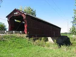
Swartz Covered Bridge | |
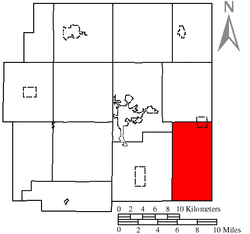 Location of Antrim Township in Wyandot County | |
| Coordinates: 40°46′25″N 83°8′47″W / 40.77361°N 83.14639°WCoordinates: 40°46′25″N 83°8′47″W / 40.77361°N 83.14639°W | |
| Country | United States |
| State | Ohio |
| County | Wyandot |
| Area | |
| • Total | 32.3 sq mi (83.6 km2) |
| • Land | 32.3 sq mi (83.6 km2) |
| • Water | 0.0 sq mi (0.0 km2) |
| Elevation[1] | 922 ft (281 m) |
| Population (2000) | |
| • Total | 1,275 |
| • Density | 39.5/sq mi (15.3/km2) |
| Time zone | Eastern (EST) (UTC-5) |
| • Summer (DST) | EDT (UTC-4) |
| FIPS code | 39-02190[2] |
| GNIS feature ID | 1087202[1] |
Antrim Township is one of the thirteen townships of Wyandot County, Ohio, United States. The 2000 census found 1,275 people in the township, 736 of whom lived in the unincorporated portions of the township.[3]
Geography
Located in the southeastern corner of the county, it borders the following townships:
- Eden Township - north
- Tod Township, Crawford County - northeast
- Dallas Township, Crawford County - east
- Grand Prairie Township, Marion County - south
- Salt Rock Township, Marion County - southwest corner
- Pitt Township - west
- Crane Township - northwest
Part of the village of Nevada is located in northeastern Antrim Township.
Name and history
It is the only Antrim Township statewide.
Government
The township is governed by a three-member board of trustees, who are elected in November of odd-numbered years to a four-year term beginning on the following January 1. Two are elected in the year after the presidential election and one is elected in the year before it. There is also an elected township fiscal officer,[4] who serves a four-year term beginning on April 1 of the year after the election, which is held in November of the year before the presidential election. Vacancies in the fiscal officership or on the board of trustees are filled by the remaining trustees.
References
- 1 2 "US Board on Geographic Names". United States Geological Survey. 2007-10-25. Retrieved 2008-01-31.
- ↑ "American FactFinder". United States Census Bureau. Archived from the original on 2013-09-11. Retrieved 2008-01-31.
- ↑ Wyandot County, Ohio — Population by Places Estimates Ohio State University, 2007. Accessed 15 May 2007.
- ↑ §503.24, §505.01, and §507.01 of the Ohio Revised Code. Accessed 4/30/2009.
External links
Municipalities and communities of Wyandot County, Ohio, United States | ||
|---|---|---|
| City |  | |
| Villages | ||
| Townships | ||
| CDP | ||
| Unincorporated communities | ||
| Footnotes | ‡This populated place also has portions in an adjacent county or counties. | |