Forest, Ohio
| Forest, Ohio | |
|---|---|
| Village | |
|
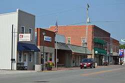
Aerial view of Forest | |
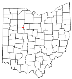 Location of Forest, Ohio | |
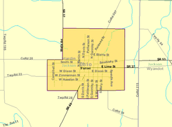 Detailed map of Forest | |
| Coordinates: 40°48′3″N 83°30′45″W / 40.80083°N 83.51250°WCoordinates: 40°48′3″N 83°30′45″W / 40.80083°N 83.51250°W | |
| Country | United States |
| State | Ohio |
| Counties | Hardin, Wyandot[1] |
| Area[2] | |
| • Total | 1.61 sq mi (4.17 km2) |
| • Land | 1.61 sq mi (4.17 km2) |
| • Water | 0 sq mi (0 km2) |
| Elevation[3] | 932 ft (284 m) |
| Population (2010)[4] | |
| • Total | 1,461 |
| • Estimate (2012[5]) | 1,432 |
| • Density | 907.5/sq mi (350.4/km2) |
| Time zone | Eastern (EST) (UTC-5) |
| • Summer (DST) | EDT (UTC-4) |
| ZIP code | 45843 |
| Area code(s) | 419 |
| FIPS code | 39-27636[6] |
| GNIS feature ID | 1048744[3] |

Forest is a village in Hardin and Wyandot counties in the U.S. state of Ohio. The population was 1,461 at the 2010 census.
History
A post office has been in operation at Forest since 1854.[7] Forest was platted in 1855 when the railroad was extended to that point.[8] The village most likely was named for the fact the original town site was a forest.[9] Forest was incorporated in 1865.[8]
Geography
Forest is located at 40°48′3″N 83°30′45″W / 40.80083°N 83.51250°W (40.800818, -83.512403).[10]
According to the United States Census Bureau, the village has a total area of 1.61 square miles (4.17 km2), all land.[2]
Demographics
| Historical population | |||
|---|---|---|---|
| Census | Pop. | %± | |
| 1880 | 987 | — | |
| 1890 | 1,126 | 14.1% | |
| 1900 | 1,155 | 2.6% | |
| 1910 | 1,285 | 11.3% | |
| 1920 | 1,143 | −11.1% | |
| 1930 | 1,103 | −3.5% | |
| 1940 | 1,083 | −1.8% | |
| 1950 | 1,114 | 2.9% | |
| 1960 | 1,314 | 18.0% | |
| 1970 | 1,535 | 16.8% | |
| 1980 | 1,633 | 6.4% | |
| 1990 | 1,594 | −2.4% | |
| 2000 | 1,488 | −6.6% | |
| 2010 | 1,461 | −1.8% | |
| Est. 2015 | 1,441 | [11] | −1.4% |
2010 census
As of the census[4] of 2010, there were 1,461 people, 550 households, and 387 families residing in the village. The population density was 907.5 inhabitants per square mile (350.4/km2). There were 646 housing units at an average density of 401.2 per square mile (154.9/km2). The racial makeup of the village was 98.0% White, 0.4% African American, 0.1% Native American, 0.1% from other races, and 1.4% from two or more races. Hispanic or Latino of any race were 1.0% of the population.
There were 550 households of which 39.1% had children under the age of 18 living with them, 53.6% were married couples living together, 12.4% had a female householder with no husband present, 4.4% had a male householder with no wife present, and 29.6% were non-families. 24.7% of all households were made up of individuals and 9.8% had someone living alone who was 65 years of age or older. The average household size was 2.66 and the average family size was 3.11.
The median age in the village was 34.2 years. 29.4% of residents were under the age of 18; 7.8% were between the ages of 18 and 24; 27.1% were from 25 to 44; 23.8% were from 45 to 64; and 11.9% were 65 years of age or older. The gender makeup of the village was 50.5% male and 49.5% female.
2000 census
As of the census[6] of 2000, there were 1,488 people, 591 households, and 410 families residing in the village. The population density was 1,253.4 people per square mile (482.8/km²). There were 644 housing units at an average density of 542.5 per square mile (208.9/km²). The racial makeup of the village was 98.52% White, 0.40% African American, 0.07% Native American, 0.34% from other races, and 0.67% from two or more races. Hispanic or Latino of any race were 0.81% of the population.
There were 591 households out of which 35.0% had children under the age of 18 living with them, 53.1% were married couples living together, 11.8% had a female householder with no husband present, and 30.5% were non-families. 26.7% of all households were made up of individuals and 9.8% had someone living alone who was 65 years of age or older. The average household size was 2.52 and the average family size was 3.04.
In the village the population was spread out with 28.5% under the age of 18, 10.7% from 18 to 24, 29.2% from 25 to 44, 19.8% from 45 to 64, and 11.8% who were 65 years of age or older. The median age was 32 years. For every 100 females there were 95.0 males. For every 100 females age 18 and over, there were 92.1 males.
The median income for a household in the village was $34,375, and the median income for a family was $38,631. Males had a median income of $31,071 versus $22,260 for females. The per capita income for the village was $15,342. About 8.1% of families and 9.7% of the population were below the poverty line, including 11.7% of those under age 18 and 8.6% of those age 65 or over.
Notable person
- Jim Karcher, American football player.
References
- ↑ Hardin County, Ohio: Online Auditor - Map, Hardin County, 2011-01-25. Accessed 2011-01-25.
- 1 2 "US Gazetteer files 2010". United States Census Bureau. Retrieved 2013-01-06.
- 1 2 "US Board on Geographic Names". United States Geological Survey. 2007-10-25. Retrieved 2008-01-31.
- 1 2 "American FactFinder". United States Census Bureau. Retrieved 2013-01-06.
- ↑ "Population Estimates". United States Census Bureau. Retrieved 2013-06-17.
- 1 2 "American FactFinder". United States Census Bureau. Retrieved 2008-01-31.
- ↑ "Hardin County". Jim Forte Postal History. Retrieved 14 December 2015.
- 1 2 Kohler, Minnie Ichler (1910). A Twentieth Century History of Hardin County, Ohio: A Narrative Account of Its Historical Progress, Its People and Principal Interests,. Lewis Publishing Company. p. 165.
- ↑ Overman, William Daniel (1958). Ohio Town Names. Akron, OH: Atlantic Press. p. 46.
- ↑ "US Gazetteer files: 2010, 2000, and 1990". United States Census Bureau. 2011-02-12. Retrieved 2011-04-23.
- ↑ "Annual Estimates of the Resident Population for Incorporated Places: April 1, 2010 to July 1, 2015". Retrieved July 2, 2016.
- ↑ "Census of Population and Housing". Census.gov. Retrieved June 4, 2015.
External links
![]() Media related to Forest, Ohio at Wikimedia Commons
Media related to Forest, Ohio at Wikimedia Commons
Municipalities and communities of Hardin County, Ohio, United States | ||
|---|---|---|
| City |  | |
| Villages | ||
| Townships | ||
| CDP | ||
| Unincorporated communities | ||
| Footnotes | ‡This populated place also has portions in an adjacent county or counties | |
Municipalities and communities of Wyandot County, Ohio, United States | ||
|---|---|---|
| City |  | |
| Villages | ||
| Townships | ||
| CDP | ||
| Unincorporated communities | ||
| Footnotes | ‡This populated place also has portions in an adjacent county or counties. | |