Aoba Castle
| Aoba Castle 青葉城 | |
|---|---|
| Sendai, Miyagi Prefecture, Japan | |
|
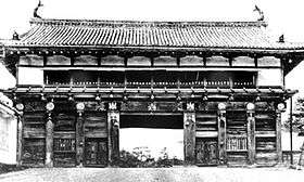
Reconstructed Wakiyagura of Aoba Castle | |
| Type | hilltop-style Japanese castle |
| Site information | |
| Open to the public | yes |
| Site history | |
| Built | 1601 |
| Built by | Date Masamune |
| In use | Edo period |

Aoba Castle (青葉城 Aoba-jō) is a Japanese castle located in Sendai, Miyagi Prefecture, Japan. Throughout the Edo period, Aoba Castle was home to the Date clan, daimyō of Sendai Domain. The castle was also known as Sendai-jō (仙台城) or as Gojō-rō (五城楼). In 2003, the castle site was designated a National Historic Monument.
Design
Aoba Castle is located on a plateau overlooking the city of Sendai on the opposing bank of the Hirose River. The site is protected by cliffs to the south and east, and by a deep forest to the west. This forest was strictly guarded in the Edo period and is a rare survivor of the original virgin forests in Honshu. The area is now managed as a botanical garden by Tohoku University. While the natural defenses of the castle were extensive, the man-made defensive structures of the castle were minimal, as its role was more administrative and ceremonial than military.
History
The site of Aoba Castle, a small hill called “Mount Aoba” was the site of a fortified residence of a branch of the Shimazu clan, the nominal kokushi of Mutsu Province from the early Kamakura period. In the Muromachi period, it was controlled by the Ji-samurai Kokubun clan, which was in turn destroyed by the Date clan.
Following the Battle of Sekigahara, in 1601, the area was visited by Tokugawa Ieyasu, who renamed “Mount Aoba” as “Sendai”. The first daimyo of Sendai Domain, Date Masamune began construction of the castle with the central bailey and San-no-Maru bailey at the base of the hill. Plans for the tenshu, equivalent to the main keep of European castles, were drawn, but only the foundation base was ever built. Work on the castle, including the San-no-Maru bailey and numerous gates was completed by Date Tadamune in 1637.
After completion, castle served as the headquarters of the Date clan and administrative center of Mutsu Province under the Tokugawa shogunate. The Ni-no-Maru was used for both governmental functions and was the location of the palace of the daimyo. The Main Bailey was used only for certain ceremonial functions.
The castle was destroyed repeatedly by earthquakes and fires, notably in 1616, 1648, 1668 and 1710. More than six major earthquakes occurred between 1710 and 1868, but there is no record of major damage.
During the Bakumatsu period, the castle was one of the nerve centers of the Ōuetsu Reppan Dōmei during the Boshin War, when Date Yoshikuni was lord of Sendai. Taken over by the Meiji government in the aftermath of Sendai's surrender, it was partially dismantled in the 1870s, and the grounds were given over to the Imperial Japanese Army, who used it as the base for the Sendai Garrison (later the IJA 2nd Division. A large fire in 1882 destroyed many of the remaining structures of the castle.
In 1902, a Shinto shrine, the Gokoku Shrine (護国神社 Gokoku-jinja) honoring the war dead, was established. In 1931, two of the few remaining structures of the castle, the Omotemon Gate and the Wakiyagura tower, were designated as National Treasures by the Japanese government. However, these structures and all else in the castle were destroyed completely on July 10, 1945 by the United States during the Bombing of Sendai during World War II.
During the occupation of Japan, the castle site came under the control of the United States Army, which razed any remaining Edo period structures. It was returned to Japan in 1957. In 1961, the Sendai City Museum was built on the site of the San-no-Maru enclosure. Over the next decades, stone base, some walls, and some wooden structures, have been rebuilt to increase the tourist potential of the site, and in 2006, Aoba Castle was designated one of the 100 Fine Castles of Japan.
Literature
- Schmorleitz, Morton S. (1974). Castles in Japan. Tokyo: Charles E. Tuttle Co. pp. 144–145. ISBN 0-8048-1102-4.
- Motoo, Hinago (1986). Japanese Castles. Tokyo: Kodansha. p. 200 pages. ISBN 0-87011-766-1.
- Mitchelhill, Jennifer (2004). Castles of the Samurai: Power and Beauty. Tokyo: Kodansha. p. 112 pages. ISBN 4-7700-2954-3.
- Turnbull, Stephen (2003). Japanese Castles 1540-1640. Osprey Publishing. p. 64 pages. ISBN 1-84176-429-9.
External links
Notes
100 Fine Castles of Japan by region | ||
|---|---|---|
| Hokkaidō |  | |
| Tōhoku | ||
| Kantō | ||
| Chūbu | ||
| Kansai | ||
| Chūgoku | ||
| Shikoku | ||
| Kyūshūa | ||
a including Okinawa. | ||
Coordinates: 38°15′09″N 140°51′22″E / 38.252478°N 140.856156°E