Arctic Corsair
 Arctic Corsair | |
| History | |
|---|---|
| Name: | Arctic Corsair[1][2] |
| Owner: | Boyd Line Hull |
| Port of registry: | Hull |
| Builder: | Cook, Welton & Gemmell, Beverley |
| Yard number: | 959 |
| Launched: | 29 February 1960 |
| Renamed: | Arctic Cavalier (15 January 1988), back to Arctic Corsair (18 June 1993) |
| Identification: | H320 |
| Fate: | Museum ship |
| General characteristics | |
| Class and type: | Diesel side-fishing trawler |
| Tonnage: | 256 long tons (260 t) nett, 764 long tons (776 t) gross |
| Length: | 187.1 ft (57.0 m) |
| Beam: | 33.6 ft (10.2 m) |
| Installed power: | 1,800 bhp (1,300 kW) |
| Propulsion: | 6-cylinder Mirrlees Monarch diesel engine |
| Speed: | 15 knots (28 km/h) |
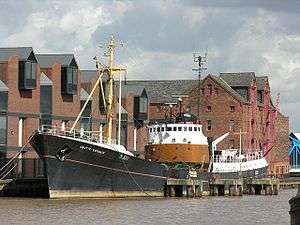
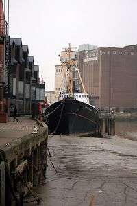
The Arctic Corsair (H320) is a deep-sea trawler that was converted to a museum ship in 1999. It is berthed between Drypool Bridge and Myton Bridge in the River Hull in Hull, England, and is part of the city's Museums Quarter.
Exhibits and guides aboard the boat tell the story of Hull's deep-sea fishing industry.
History
The Arctic Corsair is Hull’s last surviving sidewinder trawler,[3] a type of ship that formed the backbone of the city’s deep sea fishing fleet. She was built in 1960, at Cook, Welton & Gemmell in Beverley, and was the second diesel-engined trawler built for the Boyd Line, the first being the Arctic Cavalier which was launched the previous month.[1] She was designed for the harsh conditions encountered in the Icelandic grounds, having a rivetted rather than welded hull.[4]
In September 1967 she was holed on her starboard side in a collision off the coast of Scotland with the Irish collier Olive in thick fog.[4] Attempting to reach harbour in Wick she was beached in Sinclair Bay but eventually repaired and refloated.[1]
In 1973, the Arctic Corsair broke the world record for landing of cod and haddock from the White Sea.
On 30 April 1976 during the cod wars, she rammed the offshore patrol vessel ICGV Odin in the stern, after Odin had made three attempts to cut the Corsair's trawl warps.[5] The skipper, Charles Pitts, said that Icelandic seamen were becoming "more ambitious and dangerous in their tactics". With his ship holed below the waterline, and patched up temporarily by the Royal Navy, Pitts decided to head for home for permanent repairs.[6] Arctic Corsair was out of action for several months.[3][4]
In 1978 she was converted for midwater trawling, and in 1981 laid up at Hull. In 1985 she was taken out of retirement and reconverted for normal fishing. She was renamed Arctic Cavalier in 1988. She was sold to Hull City Council in 1993, renamed Arctic Corsair again, and moored in the River Hull for use as a museum ship.[1]
After being restored by trainees and volunteers from the fishing heritage group STAND, the floating museum opened to the public in 1999. STAND entered into partnership with the City Council to provide volunteers to maintain and act as tour guides. Today, the floating museum is run entirely by volunteers but supported by Hull City Council. Vessel is open Wednesday, Saturday and Sundays (and Bank Holiday Mondays) from Easter until end of October. Guided tours are free.
Skippers
Many people worked on the ship during her long career. Her usual crew numbered 24. Skippers include:
- Trevor Burnett
- Bernard Wharam
- Stanley Barwick
- Harry Waudby
- Richard Sackville-Bryant
- James Brocklesby
- Philip Garner
See also
- List of ship launches in 1960
- Middle-water trawler Ross Tiger, last surviving vessel of the rival fleet across the Humber at Grimsby
- Viola (trawler) Middle-water traditional 'bridge-aft-sider' trawler. In derelict condition with hopes of regeneration.
References
- 1 2 3 4 and all infobox info:Thompson, Michael; Newton, Dave; Robinson, Richard; Lofthouse, Tony (1999). Cook, Welton & Gemmell: shipbuilders of Hull and Beverley. Hutton Press Ltd. p. 243. ISBN 1-902709-02-0.
- ↑ "Arctic Corsair". Archived from the original on 4 March 2009. Retrieved 2 March 2009.
- 1 2 Hull City Council (2009). "Arctic Corsair". Retrieved 25 February 2009.
- 1 2 3 "A trawler built to withstand harsh conditions". Hull Daily Mail. Northcliffe Electronic Publishing. 24 September 2007. Retrieved 19 March 2009.
- ↑ "Holed trawler 'in no danger' after collision". The Times (Issue 59693). 1 May 1976. p. 4.
- ↑ Hornsby, Michael; Clayton, Hugh (5 May 1976). "Britain lays claim to 50 miles of fishing rights". The Times (Issue 59696). pp. 1, 5.
External links
| Wikimedia Commons has media related to Arctic Corsair (ship, 1960). |
- "Arctic Corsair" - Hull City Council
Coordinates: 53°44′34″N 0°19′40″W / 53.74278°N 0.32778°W