Arkansas Highway 50
| ||||
|---|---|---|---|---|
 | ||||
| Route information | ||||
| Maintained by AHTD | ||||
| Existed: | 1926 – present | |||
| Section 1 | ||||
| Length: | 27.96 mi[1] (45.00 km) | |||
| West end: |
| |||
| East end: |
| |||
| Section 2 | ||||
| Length: | 15.84 mi[1] (25.49 km) | |||
| West end: |
| |||
| East end: |
| |||
| Location | ||||
| Counties: | St. Francis, Crittenden | |||
| Highway system | ||||
| ||||

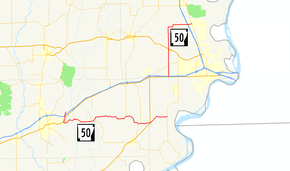
Highway 50 (AR 50, Ark. 50, or Hwy. 50) is a designation for two east–west state highways in northeast Arkansas. A western route of 27.96 miles (45.00 km) runs east from St. Francis County Route 415 (CR 415) to Highway 147 near Anthonyville.[2] A second route of 15.84 miles (25.49 km) begins at US Route 70 (US 70) and runs east to Highway 77 in Clarkedale.[3]
Route description
Forrest City to Anthonyville
Highway 50 begins at CR 415 north of Forrest City and runs south across Interstate 40 (I-40), although there is no interchange. The route continues south to Madison where it intersects US 70. The highway then crosses over the St. Francis River to enter Widener, where a concurrency begins with Highway 38. The two routes run together east to serve as the southern terminus of Highway 75 before Highway 38 splits south to Hughes. Continuing east, a short concurrency begins with Highway 149, ending near Greasy Corner. Highway 50 runs east to serve as the southern terminus of Highway 357 before a junction with US 79 on the Crittenden County line. Shortly after entering Crittenden County, Highway 50 terminates at Highway 147 south of Anthonyville.
US 70 to Clarkedale
Highway 50 begins northwest of Edmondson at US 70, which acts as a frontage road for I-40/US 63/US 79. The route runs north across Highway 218 to Crawfordsville. In Crawfordsville, Highway 50 briefly overlaps US 64B before crossing US 64 just north of town. The highway continues north before later turning east to a junction with I-55/US 61/US 63 in Clarkedale. The route terminates just east of this interchange at Highway 77 in Clarkedale.
Major intersections
| County | Location | mi[1] | km | Destinations | Notes | ||
|---|---|---|---|---|---|---|---|
| St. Francis | | 0.00 | 0.00 | ||||
| Madison | 2.27 | 3.65 | |||||
| 2.82– 2.96 | 4.54– 4.76 | Bridge over St. Francis River | |||||
| Widener | 5.19 | 8.35 | West end of AR 38 overlap | ||||
| | 8.87 | 14.27 | |||||
| | 9.46 | 15.22 | East end of AR 38 overlap | ||||
| | 17.67 | 28.44 | West end of AR 149 overlap | ||||
| Greasy Corner | 21.23 | 34.17 | East end of AR 149 overlap | ||||
| | 21.66 | 34.86 | |||||
| Chatfield | 23.69 | 38.13 | |||||
| Crittenden | 96 Corner | 27.96 | 45.00 | ||||
| Gap in route | |||||||
| | 0.00 | 0.00 | |||||
| | 2.47 | 3.98 | |||||
| | Bucklake Road | Former AR 306 east | |||||
| Crawfordsville | 5.51 | 8.87 | South end of US 64B overlap | ||||
| | 0.00 | 0.00 | North end of US 64B overlap | ||||
| Clarkedale | 9.41 | 15.14 | I-55 exit 16 | ||||
| 10.33 | 16.62 | ||||||
1.000 mi = 1.609 km; 1.000 km = 0.621 mi
| |||||||
See also
 Arkansas portal
 U.S. Roads portal
References
- 1 2 3 Planning and Research Division (March 28, 2012). "Arkansas Road Log Database" (MBD). Arkansas State Highway and Transportation Department. Retrieved April 13, 2012.
- ↑ General Highway Map, St. Francis County, Arkansas (PDF) (Map). 1:62500. Cartography by Planning and Research Division. Arkansas State Highway and Transportation Department. December 15, 2007. Retrieved May 19, 2012.
- ↑ General Highway Map, Crittenden County, Arkansas (PDF) (Map). 1:62500. Cartography by Planning and Research Division. Arkansas State Highway and Transportation Department. Retrieved May 19, 2012.
Roads of Memphis | |||||||||||
|---|---|---|---|---|---|---|---|---|---|---|---|
| Interstate Highways | 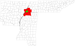 | ||||||||||
| U.S. Highways | |||||||||||
| State Highways |
| ||||||||||
| Other Highways | |||||||||||