Ashkum Township, Iroquois County, Illinois
| Ashkum Township | |
|---|---|
| Township | |
|
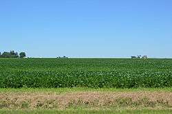
Fields west of Ashkum | |
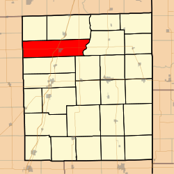 Location in Iroquois County | |
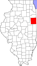 Iroquois County's location in Illinois | |
| Coordinates: 40°52′50″N 87°58′33″W / 40.88056°N 87.97583°WCoordinates: 40°52′50″N 87°58′33″W / 40.88056°N 87.97583°W | |
| Country | United States |
| State | Illinois |
| County | Iroquois |
| Established | March, 1857 |
| Area | |
| • Total | 62.47 sq mi (161.8 km2) |
| • Land | 62.37 sq mi (161.5 km2) |
| • Water | 0.1 sq mi (0.3 km2) 0.16% |
| Elevation | 673 ft (205 m) |
| Population (2010) | |
| • Total | 1,542 |
| • Density | 24.7/sq mi (9.5/km2) |
| Time zone | CST (UTC-6) |
| • Summer (DST) | CDT (UTC-5) |
| ZIP codes | 60911, 60927, 60930 |
| GNIS feature ID | 0428607 |
Ashkum Township is one of twenty-six townships in Iroquois County, Illinois, USA. As of the 2010 census, its population was 1,542 and it contained 662 housing units.[1] Ashkum Township formed from portions of Chebanse Township and Onarga Township in March, 1857.
Geography
According to the 2010 census, the township has a total area of 62.47 square miles (161.8 km2), of which 62.37 square miles (161.5 km2) (or 99.84%) is land and 0.1 square miles (0.26 km2) (or 0.16%) is water.[1]
Cities, towns, villages
Unincorporated towns
Cemeteries
The township contains L'Erable Catholic Cemetery.
Major highways
School districts
- Central Community Unit School District 4
- Iroquois West Community Unit School District 10
- Tri Point Community Unit School District 6-J
Political districts
- Illinois' 15th congressional district
- State House District 75
- State House District 105
- State Senate District 38
- State Senate District 53
- Iroquois County Board District 1
References
- "Ashkum Township, Iroquois County, Illinois". Geographic Names Information System. United States Geological Survey. Retrieved 2010-01-17.
- United States Census Bureau 2007 TIGER/Line Shapefiles
- United States National Atlas
- 1 2 "Population, Housing Units, Area, and Density: 2010 - County -- County Subdivision and Place -- 2010 Census Summary File 1". United States Census. Retrieved 2013-05-28.
External links
 |
Milks Grove Township | |
Chebanse Township | |
| Mona Township, Ford County Pella Township, Ford County |
|
Martinton Township | ||
| ||||
| | ||||
| Danforth Township | Iroquois Township |
Municipalities and communities of Iroquois County, Illinois, United States | ||
|---|---|---|
| Cities | ||
| Villages | ||
| Townships | ||
| Unincorporated communities |
| |
| Footnotes | ‡This populated place also has portions in an adjacent county or counties | |
This article is issued from Wikipedia - version of the 10/19/2016. The text is available under the Creative Commons Attribution/Share Alike but additional terms may apply for the media files.