Atkinson, Maine
| Atkinson, Maine | |
|---|---|
| Town | |
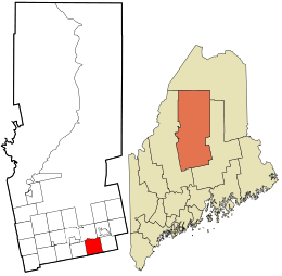 Location in Piscataquis County and the state of Maine. | |
| Coordinates: 45°9′25″N 69°3′37″W / 45.15694°N 69.06028°WCoordinates: 45°9′25″N 69°3′37″W / 45.15694°N 69.06028°W | |
| Country | United States |
| State | Maine |
| County | Piscataquis |
| Area[1] | |
| • Total | 39.05 sq mi (101.14 km2) |
| • Land | 38.79 sq mi (100.47 km2) |
| • Water | 0.26 sq mi (0.67 km2) |
| Elevation | 318 ft (97 m) |
| Population (2010)[2] | |
| • Total | 326 |
| • Estimate (2012[3]) | 321 |
| • Density | 8.4/sq mi (3.2/km2) |
| Time zone | Eastern (EST) (UTC-5) |
| • Summer (DST) | EDT (UTC-4) |
| ZIP code | 04426 |
| Area code(s) | 207 |
| FIPS code | 23-01920 |
| GNIS feature ID | 0582332 |
Atkinson is a town in Piscataquis County, Maine, United States. The town was named after Judge Atkinson, a landholder.[4] The population was 326 at the 2010 census.
Geography
According to the United States Census Bureau, the town has a total area of 39.05 square miles (101.14 km2), of which, 38.79 square miles (100.47 km2) of it is land and 0.26 square miles (0.67 km2) is water.[1]
Demographics
| Historical population | |||
|---|---|---|---|
| Census | Pop. | %± | |
| 1820 | 245 | — | |
| 1830 | 418 | 70.6% | |
| 1840 | 704 | 68.4% | |
| 1850 | 895 | 27.1% | |
| 1860 | 897 | 0.2% | |
| 1870 | 810 | −9.7% | |
| 1880 | 828 | 2.2% | |
| 1890 | 605 | −26.9% | |
| 1900 | 495 | −18.2% | |
| 1910 | 528 | 6.7% | |
| 1920 | 456 | −13.6% | |
| 1930 | 394 | −13.6% | |
| 1940 | 312 | −20.8% | |
| 1950 | 400 | 28.2% | |
| 1960 | 280 | −30.0% | |
| 1970 | 213 | −23.9% | |
| 1980 | 306 | 43.7% | |
| 1990 | 332 | 8.5% | |
| 2000 | 323 | −2.7% | |
| 2010 | 326 | 0.9% | |
| Est. 2014 | 318 | [5] | −2.5% |
2010 census
As of the census[2] of 2010, there were 326 people, 135 households, and 91 families residing in the town. The population density was 8.4 inhabitants per square mile (3.2/km2). There were 198 housing units at an average density of 5.1 per square mile (2.0/km2). The racial makeup of the town was 96.9% White, 1.2% Native American, 0.3% Asian, 0.3% Pacific Islander, and 1.2% from two or more races. Hispanic or Latino of any race were 0.3% of the population.
There were 135 households of which 24.4% had children under the age of 18 living with them, 61.5% were married couples living together, 2.2% had a female householder with no husband present, 3.7% had a male householder with no wife present, and 32.6% were non-families. 23.7% of all households were made up of individuals and 11.1% had someone living alone who was 65 years of age or older. The average household size was 2.41 and the average family size was 2.89.
The median age in the town was 47.8 years. 20.2% of residents were under the age of 18; 5% were between the ages of 18 and 24; 21.9% were from 25 to 44; 35% were from 45 to 64; and 18.1% were 65 years of age or older. The gender makeup of the town was 53.7% male and 46.3% female.
2000 census
As of the census[7] of 2000, there were 323 people, 132 households, and 97 families residing in the town. The population density was 8.2 people per square mile (3.2/km²). There were 198 housing units at an average density of 5.1 per square mile (2.0/km²). The racial makeup of the town was 99.69% White, and 0.31% from two or more races. Hispanic or Latino of any race were 0.31% of the population.
There were 132 households out of which 27.3% had children under the age of 18 living with them, 68.9% were married couples living together, 0.8% had a female householder with no husband present, and 25.8% were non-families. 18.9% of all households were made up of individuals and 4.5% had someone living alone who was 65 years of age or older. The average household size was 2.45 and the average family size was 2.81.
In the town the population was spread out with 23.5% under the age of 18, 4.6% from 18 to 24, 30.3% from 25 to 44, 29.7% from 45 to 64, and 11.8% who were 65 years of age or older. The median age was 41 years. For every 100 females there were 105.7 males. For every 100 females age 18 and over, there were 107.6 males.
The median income for a household in the town was $29,821, and the median income for a family was $32,083. Males had a median income of $30,469 versus $25,313 for females. The per capita income for the town was $14,755. About 8.9% of families and 17.9% of the population were below the poverty line, including 39.4% of those under age 18 and 5.3% of those age 65 or over.
Notable people
- Edward Bunker, Mormon pioneer, founded Bunkerville, Nevada
- The infamous Israel Dammon trial occurred here.
References
- 1 2 "US Gazetteer files 2010". United States Census Bureau. Retrieved 2012-12-16.
- 1 2 "American FactFinder". United States Census Bureau. Retrieved 2012-12-16.
- ↑ "Population Estimates". United States Census Bureau. Archived from the original on 2013-06-17. Retrieved 2013-07-06.
- ↑ "Profile for Atkinson, Maine". ePodunk. Retrieved 2010-05-07.
- ↑ "Annual Estimates of the Resident Population for Incorporated Places: April 1, 2010 to July 1, 2014". Retrieved June 4, 2015.
- ↑ "Census of Population and Housing". Census.gov. Archived from the original on May 11, 2015. Retrieved June 4, 2015.
- ↑ "American FactFinder". United States Census Bureau. Archived from the original on 2013-09-11. Retrieved 2008-01-31.
External links
- Town of Atkinson, Maine
- Three Rivers Community of Maine
- Photograph of Atkinson, Maine, ca. 1900, from the Maine Memory Network
Municipalities and communities of Piscataquis County, Maine, United States | ||
|---|---|---|
| Towns | 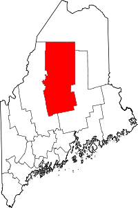 | |
| Plantations | ||
| Unorganized territories | ||
| CDPs | ||