Caspian Sea
| Caspian Sea | |
|---|---|
| Xəzər dənizi / دریای کاسپین، دریای خزر / Каспий теңізі / Каспийское море / Hazar deňzi | |
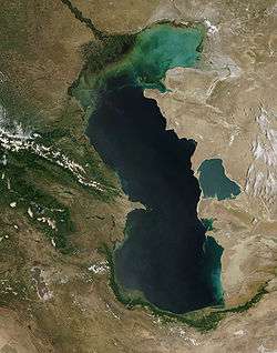 The Caspian Sea as captured by the MODIS on the orbiting Terra satellite, June 2003 | |
| Coordinates | 41°40′N 50°40′E / 41.667°N 50.667°ECoordinates: 41°40′N 50°40′E / 41.667°N 50.667°E |
| Type | Endorheic, Saline, Permanent, Natural |
| Primary inflows | Volga River, Ural River, Kura River, Terek River |
| Primary outflows | Evaporation |
| Catchment area | 3,626,000 km2 (1,400,000 sq mi)[1] |
| Basin countries | Azerbaijan, Iran, Kazakhstan, Russia, Turkmenistan |
| Max. length | 1,030 km (640 mi) |
| Max. width | 435 km (270 mi) |
| Surface area | 371,000 km2 (143,200 sq mi) |
| Average depth | 211 m (690 ft) |
| Max. depth | 1,025 m (3,360 ft) |
| Water volume | 78,200 km3 (18,800 cu mi) |
| Residence time | 250 years |
| Shore length1 | 7,000 km (4,300 mi) |
| Surface elevation | −28 m (−92 ft) |
| Islands | 26+ |
| Settlements | Baku (Azerbaijan), Anzali (Iran), Aktau (Kazakhstan), Makhachkala (Russia), Türkmenbaşy (Turkmenistan) (see article) |
| References | [1] |
| 1 Shore length is not a well-defined measure. | |
The Caspian Sea is the largest enclosed inland body of water on Earth by area, variously classed as the world's largest lake or a full-fledged sea.[2][3] It is in an endorheic basin (it has no outflows) located between Europe and Asia.[4] It is bounded to the northeast by Kazakhstan, to the northwest by Russia, to the west by Azerbaijan, to the south by Iran, and to the southeast by Turkmenistan.
The Caspian Sea lies to the east of the Caucasus Mountains and to the west of the vast steppe of Central Asia. Its northern part, the Caspian Depression, is one of the lowest points on Earth. The ancient inhabitants of its coast perceived the Caspian Sea as an ocean, probably because of its saltiness and large size.
The sea has a surface area of 371,000 km2 (143,200 sq mi) (not including its detached lagoon of Garabogazköl Aylagy) and a volume of 78,200 km3 (18,800 cu mi).[5] It has a salinity of approximately 1.2% (12 g/l), about a third of the salinity of most seawater.
Etymology
The word Caspian is derived from the name of the Caspi, an ancient people who lived to the southwest of the sea in Transcaucasia.[6] Strabo wrote that "to the country of the Albanians belongs also the territory called Caspiane, which was named after the Caspian tribe, as was also the sea; but the tribe has now disappeared".[7] Moreover, the Caspian Gates, which is the name of a region in Iran's Tehran province, possibly indicates that they migrated to the south of the sea. The Iranian city of Qazvin shares the root of its name with that of the sea. In fact, the traditional Arabic name for the sea itself is Bahr al-Qazwin (Sea of Qazvin).[8]
In classical antiquity among Greeks and Persians it was called the Hyrcanian Ocean.[9] In Persian antiquity, as well as in modern Iran, it is known as the دریای خزر, Daryā-e Khazar; it is also sometimes referred to as Mazandaran Sea (Persian: دریای مازندران) in Iran.[10] Ancient Arabic sources refer to it as Baḥr Gīlān (بحر گیلان) meaning "the Gilan Sea".
Turkic languages refer to the lake as Khazar Sea. In Turkmen, the name is Hazar deňizi, in Azeri, it is Xəzər dənizi, and in modern Turkish, it is Hazar denizi. In all these cases, the second word simply means "sea", and the first word refers to the historical Khazars who had a large empire based to the north of the Caspian Sea between the 7th and 10th centuries. An exception is Kazakh, where it is called Каспий теңізі, Kaspiy teñizi (Caspian Sea).
Old Russian sources call it the Khvalyn or Khvalis Sea (Хвалынское море / Хвалисское море) after the name of Khwarezmia.[11] In modern Russian, it is called Каспи́йское мо́ре, Kaspiyskoye more.
Physical characteristics
Formation
The Caspian Sea, like the Aral Sea, Black Sea, and Lake Urmia, is a remnant of the ancient Paratethys Sea. It became landlocked about 5.5 million years ago due to tectonic uplift and a fall in sea level. During warm and dry climatic periods, the landlocked sea almost dried up, depositing evaporitic sediments like halite that were covered by wind-blown deposits and were sealed off as an evaporite sink when cool, wet climates refilled the basin. (Comparable evaporite beds underlie the Mediterranean.) Due to the current inflow of fresh water, the Caspian Sea is a freshwater lake in its northern portions. It is more saline on the Iranian shore, where the catchment basin contributes little flow. Currently, the mean salinity of the Caspian is one third that of Earth's oceans. The Garabogazköl embayment, which dried up when water flow from the main body of the Caspian was blocked in the 1980s but has since been restored, routinely exceeds oceanic salinity by a factor of 10.[2]
Geography
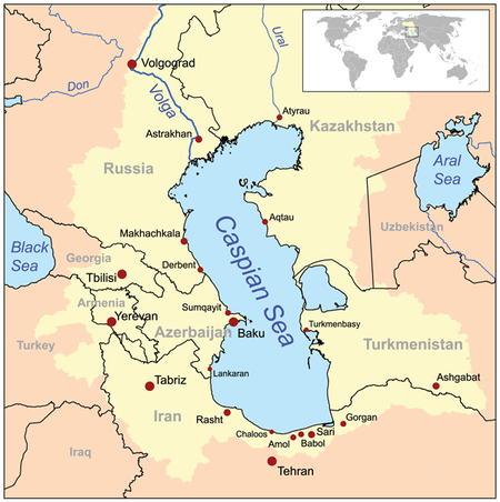
The Caspian Sea is the largest inland body of water in the world and accounts for 40 to 44% of the total lacustrine waters of the world.[12] The coastlines of the Caspian are shared by Azerbaijan, Iran, Kazakhstan, Russia, and Turkmenistan. The Caspian is divided into three distinct physical regions: the Northern, Middle, and Southern Caspian.[13] The Northern–Middle boundary is the Mangyshlak Threshold, which runs through Chechen Island and Cape Tiub-Karagan. The Middle–Southern boundary is the Apsheron Threshold, a sill of tectonic origin between the Eurasian continent and an oceanic remnant,[14] that runs through Zhiloi Island and Cape Kuuli.[15] The Garabogazköl Bay is the saline eastern inlet of the Caspian, which is part of Turkmenistan and at times has been a lake in its own right due to the isthmus that cuts it off from the Caspian.
Differences between the three regions are dramatic. The Northern Caspian only includes the Caspian shelf,[16] and is very shallow; it accounts for less than 1% of the total water volume with an average depth of only 5–6 metres (16–20 ft). The sea noticeably drops off towards the Middle Caspian, where the average depth is 190 metres (620 ft).[15] The Southern Caspian is the deepest, with oceanic depths of over 1,000 metres (3,300 ft), greatly exceeding the depth of other regional seas, such as the Persian Gulf. The Middle and Southern Caspian account for 33% and 66% of the total water volume, respectively.[13] The northern portion of the Caspian Sea typically freezes in the winter, and in the coldest winters ice forms in the south as well.[17]
Over 130 rivers provide inflow to the Caspian, with the Volga River being the largest. A second affluent, the Ural River, flows in from the north, and the Kura River flows into the sea from the west. In the past, the Amu Darya (Oxus) of Central Asia in the east often changed course to empty into the Caspian through a now-desiccated riverbed called the Uzboy River, as did the Syr Darya farther north. The Caspian also has several small islands; they are primarily located in the north and have a collective land area of roughly 2,000 km2 (770 sq mi). Adjacent to the North Caspian is the Caspian Depression, a low-lying region 27 metres (89 ft) below sea level. The Central Asian steppes stretch across the northeast coast, while the Caucasus mountains hug the western shore. The biomes to both the north and east are characterized by cold, continental deserts. Conversely, the climate to the southwest and south are generally warm with uneven elevation due to a mix of highlands and mountain ranges; the drastic changes in climate alongside the Caspian have led to a great deal of biodiversity in the region.[2]
The Caspian Sea has numerous islands throughout, all of them near the coasts; none in the deeper parts of the sea. Ogurja Ada is the largest island. The island is 37 km (23 mi) long, with gazelles roaming freely on it. In the North Caspian, the majority of the islands are small and uninhabited, like the Tyuleniy Archipelago, an Important Bird Area (IBA), although some of them have human settlements.
Hydrology
The Caspian has characteristics common to both seas and lakes. It is often listed as the world's largest lake, although it is not a freshwater lake. It contains about 3.5 times more water, by volume, than all five of North America's Great Lakes combined. The Caspian was once part of the Tethys Ocean, but became landlocked about 5.5 million years ago due to plate tectonics.[12] The Volga River (about 80% of the inflow) and the Ural River discharge into the Caspian Sea, but it has no natural outflow other than by evaporation. Thus the Caspian ecosystem is a closed basin, with its own sea level history that is independent of the eustatic level of the world's oceans.
The level of the Caspian has fallen and risen, often rapidly, many times over the centuries. Some Russian historians claim that a medieval rising of the Caspian, perhaps caused by the Amu Darya changing its inflow to the Caspian from the 13th century to the 16th century, caused the coastal towns of Khazaria, such as Atil, to flood. In 2004, the water level was 28 metres (92 feet) below sea level.
Over the centuries, Caspian Sea levels have changed in synchrony with the estimated discharge of the Volga, which in turn depends on rainfall levels in its vast catchment basin. Precipitation is related to variations in the amount of North Atlantic depressions that reach the interior, and they in turn are affected by cycles of the North Atlantic Oscillation. Thus levels in the Caspian Sea relate to atmospheric conditions in the North Atlantic thousands of miles to the northwest.
The last short-term sea-level cycle started with a sea-level fall of 3 m (9.84 ft) from 1929 to 1977, followed by a rise of 3 m (9.84 ft) from 1977 until 1995. Since then smaller oscillations have taken place.[18]
Environmental degradation
The Volga River, the largest in Europe, drains 20% of the European land area and is the source of 80% of the Caspian's inflow. Its lower reaches are heavily developed with numerous unregulated releases of chemical and biological pollutants. Although existing data are sparse and of questionable quality, there is ample evidence to suggest that the Volga is one of the principal sources of transboundary contaminants into the Caspian.
The magnitude of fossil fuel extraction and transport activity in the Caspian also poses a risk to the environment. The island of Vulf off Baku, for example, has suffered ecological damage as a result of the petrochemical industry; this has significantly decreased the number of species of marine birds in the area. Existing and planned oil and gas pipelines under the sea further increase the potential threat to the environment.[19]
The Vladamir Filanovsky field in the Russian section of the body of water was discovered for its wealth of oil in 2005. It is reportedly the largest discovery of oil that they have had in 25 years. It was announced in October 2016 that LUKOIL would start production in this region.[20]
Nature
Fauna

_4.jpg)
Sturgeons, including the beluga sturgeon, the largest freshwater fish in the world, inhabit the Caspian Sea in great numbers and yield roe (eggs) that are processed into caviar. Overfishing has depleted a number of the historic fisheries including the economic exhaustion of the tuna fishery.[21] In recent years, overfishing has threatened the sturgeon population to the point that environmentalists advocate banning sturgeon fishing completely until the population recovers. The high price of sturgeon caviar, however, allows fishermen to afford bribes to ensure the authorities look the other way, making regulations in many locations ineffective.[22] Caviar harvesting further endangers the fish stocks, since it targets reproductive females.
Reptiles native to the sea include spur-thighed tortoise (Testudo graeca buxtoni) and Horsfield's tortoise. The Caspian turtle (Mauremys caspica), although found in neighbouring areas, is a wholly freshwater species.
The zebra mussel and the common carp are native to the Caspian and Black Seas, but have become invasive species elsewhere, when introduced.
The area has given its name to several species, including the Caspian gull and the Caspian tern. The Caspian seal (Pusa caspica) is the only aquatic mammal and is endemic to the Caspian Sea, being one of very few seal species that live in inland waters, but is different from those inhabiting freshwaters due to the hydrological environment of the Caspian Sea. There are several species and subspecies of fish endemic to the Caspian Sea, including the kutum (also known as the Caspian white fish), Caspian marine shad, Caspian roach, Caspian bream (some report that the bream occurring in the Aral Sea is the same subspecies), and a Caspian "salmon" (a subspecies of trout, Salmo trutta caspiensis), which is critically endangered.[22]
Archeological studies of Gobustan petroglyphs indicate that there once had been dolphins and porpoises[23][24] likely present in the Caspian Sea at least until the Quaternary period.[25] Although the rock art on Kichikdash Mountain, assumed to be of a dolphin[26] might instead represent the famous beluga sturgeon due to its size (430 cm or 170 in in length), fossil records suggest certain ancestors of modern dolphins and whales, such as Macrokentriodon morani (bottlenose dolphins) and Balaenoptera sibbaldina (blue whales), were presumably larger than their present descendants. From the same artworks, auks such as Brunnich’s guillemot could also have been in the sea; the existence of current endemic, oceanic species and these petroglyphs suggests marine inflow between the current Caspian Sea and the Arctic Ocean, the North Sea, or the Black Sea.[26]
Flora
Many rare and endemic plant species of Russia are associated with the tidal areas of the Volga delta and riparian forests of the Samur River delta. The shoreline is also a unique refuge for plants adapted to the loose sands of the Central Asian Deserts. The principal limiting factors to successful establishment of plant species are hydrological imbalances within the surrounding deltas, water pollution, and various land reclamation activities. The water level change within the Caspian Sea is an indirect reason for which plants may not get established. This affects aquatic plants of the Volga delta, such as Aldrovanda vesiculosa and the native Nelumbo caspica. About 11 plant species are found in the Samur River delta, including the unique liana forests that date back to the Tertiary period.
The rising level of the Caspian Sea between 1994–96 reduced the number of habitats for rare species of aquatic vegetation. This has been attributed to a general lack of seeding material in newly formed coastal lagoons and water bodies.
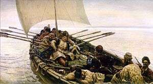
History
_Empire_1747.JPG)
The earliest hominid remains found around the Caspian Sea are from Dmanisi dating back to around 1.8 Ma and yielded a number of skeletal remains of Homo erectus or Homo ergaster. More later evidence for human occupation of the region come from a number of caves in Georgia and Azerbaijan such as Kudaro and Azykh Caves. There is evidence for Lower Palaeolithic human occupation south of the Caspian from western Alburz. These are Ganj Par and Darband Cave sites.
Neanderthal remains also have been discovered at a cave site in Georgia. Discoveries in the Huto cave and the adjacent Kamarband cave, near the town of Behshahr, Mazandaran south of the Caspian in Iran, suggest human habitation of the area as early as 11,000 years ago.[27][28]
The Caspian area is rich in energy resources. Wells were being dug in the region as early as the 10th century.[29] By the 16th century, Europeans were aware of the rich oil and gas deposits around the area. English traders Thomas Bannister and Jeffrey Duckett described the area around Baku as "a strange thing to behold, for there issueth out of the ground a marvelous quantity of oil, which serveth all the country to burn in their houses. This oil is black and is called nefte. There is also by the town of Baku, another kind of oil which is white and very precious (i.e., petroleum)."[30]
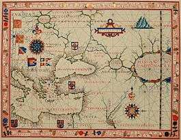
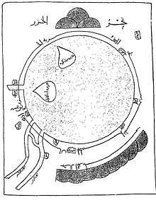
In the 18th century, during the rule of Peter I the Great, Fedor I. Soimonov, hydrographer and pioneering explorer of the Caspian Sea charted the until then little known body of water. Soimonov drew a set of four maps and wrote the 'Pilot of the Caspian Sea', the first report and modern maps of the Caspian, that were published in 1720 by the Russian Academy of Sciences.[31]
Today, oil and gas platforms are abounding along the edges of the sea.[32]
Cities

Ancient
- Hyrcania, ancient state in the north of Iran
- Anzali, Gilan Province of Iran
- Astara, Gilan Province of Iran
- Astarabad, Mazandaran Province of Iran
- Tamisheh, Mazandaran Province of Iran
- Atil, Khazaria
- Khazaran
- Baku, Azerbaijan
- Derbent, Dagestan, Russia
- Xacitarxan, modern-day Astrakhan
Modern
- Iran:
- Azerbaijan:
- Kazakhstan:
- Russia:
- Turkmenistan:
- Türkmenbaşy (formerly Krasnovodsk)
- Hazar (formerly Çeleken)
- Esenguly
- Garabogaz (formerly Bekdaş)
Oil extraction
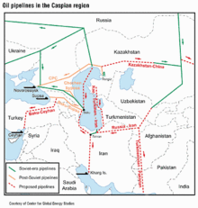
The world's first offshore wells and machine-drilled wells were made in Bibi-Heybat Bay, near Baku, Azerbaijan. In 1873, exploration and development of oil began in some of the largest fields known to exist in the world at that time on the Absheron peninsula near the villages of Balakhanli, Sabunchi, Ramana and Bibi Heybat. Total recoverable reserves were more than 500 million tons. By 1900, Baku had more than 3,000 oil wells, 2,000 of which were producing at industrial levels. By the end of the 19th century, Baku became known as the "black gold capital", and many skilled workers and specialists flocked to the city.
By the beginning of the 20th century, Baku was the centre of international oil industry. In 1920, when the Bolsheviks captured Azerbaijan, all private property – including oil wells and factories – was confiscated. Afterwards, the republic's entire oil industry came under the control of the Soviet Union. By 1941, Azerbaijan was producing a record 23.5 million tons of oil, and the Baku region supplied nearly 72% of all oil extracted in the entire USSR.[29]
In 1994, the "Contract of the Century" was signed, signalling the start of major international development of the Baku oil fields. The Baku–Tbilisi–Ceyhan pipeline, a major pipeline allowing Azerbaijan oil to flow straight to the Turkish Mediterranean port of Ceyhan, opened in 2006.
Political issues
Many of the islands along the Azerbaijani coast continue to hold significant geopolitical and economic importance because of the potential oil reserves found nearby. Bulla Island, Pirallahı Island, and Nargin, which was used as a former Soviet base and is the largest island in the Baku bay, all hold oil reserves.
The collapse of the USSR and subsequent opening of the region has led to an intense investment and development scramble by international oil companies. In 1998, Dick Cheney commented that "I can't think of a time when we've had a region emerge as suddenly to become as strategically significant as the Caspian."[33]
A key problem to further development in the region is the status of the Caspian Sea and the establishment of the water boundaries among the five littoral states. The current disputes along Azerbaijan's maritime borders with Turkmenistan and Iran could potentially affect future development plans.
Much controversy currently exists over the proposed Trans-Caspian oil and gas pipelines. These projects would allow Western markets easier access to Kazakh oil and, potentially, Uzbek and Turkmen gas as well. Russia officially opposes the project on environmental grounds. However, analysts note that the pipelines would bypass Russia completely, thereby denying the country valuable transit fees, as well as destroying its current monopoly on westward-bound hydrocarbon exports from the region.[34] Recently, both Kazakhstan and Turkmenistan have expressed their support for the Trans-Caspian Pipeline.[35]
U.S. diplomatic cables disclosed by WikiLeaks revealed that BP covered up a gas leak and blowout incident in September 2008 at an operating gas field in the Azeri-Chirag-Guneshi area of the Azerbaijan Caspian Sea.[36][37]
Territorial status
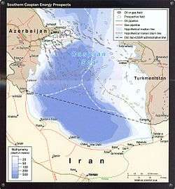
As of 2000, negotiations related to the demarcation of the Caspian Sea had been going on for nearly a decade among the states bordering the Caspian – Azerbaijan, Russia, Kazakhstan, Turkmenistan, and Iran. The status of the Caspian Sea[38] is the key problem. Access to mineral resources (oil and natural gas), access for fishing, and access to international waters (through Russia's Volga river and the canals connecting it to the Black Sea and Baltic Sea) all depend upon the outcomes of negotiations. Access to the Volga River is particularly important for the landlocked states of Azerbaijan, Kazakhstan, and Turkmenistan. This concerns Russia, because the potential traffic would use its inland waterways. If a body of water is labelled as a sea, then there would be some precedents and international treaties obliging the granting of access permits to foreign vessels. If a body of water is labelled merely as a lake, then there are no such obligations. Environmental issues are also somewhat connected to the status and borders issue.
All five Caspian littoral states maintain naval forces on the sea.[39]
According to a treaty signed between Iran and the Soviet Union, the Caspian Sea is technically a lake and was divided into two sectors (Iranian and Soviet), but the resources (then mainly fish) were commonly shared. The line between the two sectors was considered an international border in a common lake, like Lake Albert. The Soviet sector was sub-divided into the four littoral republics' administrative sectors.
Russia, Kazakhstan, and Azerbaijan have bilateral agreements with each other based on median lines. Because of their use by the three nations, median lines seem to be the most likely method of delineating territory in future agreements. However, Iran insists on a single, multilateral agreement between the five nations (as this is the only way for it to achieve a one-fifth share of the sea). Azerbaijan is at odds with Iran over some oil fields that both states claim. Occasionally, Iranian patrol boats have fired at vessels sent by Azerbaijan for exploration into the disputed region. There are similar tensions between Azerbaijan and Turkmenistan (the latter claims that the former has pumped more oil than agreed from a field, recognized by both parties as shared).
The Caspian littoral states' meeting in 2007 signed an agreement that bars any ship not flying the national flag of a littoral state from entering the sea.[40]
Negotiations among the five littoral states have been ongoing, amidst ebbs and flows, for the past 20 years, with some degree of progress being made at the fourth Caspian Summit held in Astrakhan in 2014.[41]
Cross-border inflow
UNECE recognizes several rivers that cross international borders which flow into the Caspian Sea.[42] These are:
| River | Countries |
|---|---|
| Atrek River | Iran, Turkmenistan |
| Kura River | Armenia, Azerbaijan, Georgia, Iran, Turkey |
| Ural River | Kazakhstan, Russia |
| Samur River | Azerbaijan, Russia |
| Sulak River | Georgia, Russia |
| Terek River | Georgia, Russia |
Transport
Although the Caspian Sea is endorheic, its main tributary, the Volga, is connected by important shipping canals with the Don River (and thus the Black Sea) and with the Baltic Sea, with branch canals to Northern Dvina and to the White Sea.
Another Caspian tributary, the Kuma River, is connected by an irrigation canal with the Don basin as well.
Several scheduled ferry services (including train ferries) operate on the Caspian Sea, including:
- a line between Türkmenbaşy, Turkmenistan (formerly Krasnovodsk) and Baku.
- a line between Baku and Aktau.
- several lines between cities in Iran and Russia.
The ferries are mostly used for cargo, only the Baku – Aktau and Baku – Türkmenbaşy routes accept passengers.
Canals
As an endorheic basin, the Caspian Sea basin has no natural connection with the ocean. Since the medieval period, traders reached the Caspian via a number of portages that connected the Volga and its tributaries with the Don (which flows into the Sea of Azov) and various rivers that flow into the Baltic. Primitive canals connecting the Volga Basin with the Baltic have been constructed as early as the early 18th century; since then, a number of canal projects have been completed. The two modern canal systems connecting the Volga basin with the ocean are the Volga–Baltic Waterway and the Volga–Don Canal.
The proposed Pechora-Kama Canal was a project that was widely discussed between the 1930s and 1980s. Shipping was a secondary consideration; its main goal was to redirect some of the water of the Pechora River (which flows into the Arctic Ocean) via the Kama into the Volga. The goals were both irrigation and stabilizing the water level in the Caspian, which was thought to be falling dangerously fast at the time. In 1971 some construction experiments were conducted using nuclear explosions.
In June 2007, in order to boost his oil-rich country's access to markets, Kazakhstan's President Nursultan Nazarbaev proposed a 700-kilometre (435-mile) link between the Caspian and Black seas. It is hoped that the "Eurasia Canal" (Manych Ship Canal) would transform landlocked Kazakhstan and other Central Asian countries into maritime states, enabling them to significantly increase trade volume. Although the canal would traverse Russian territory, it would benefit Kazakhstan through its Caspian Sea ports. The most likely route for the canal, the officials at the Committee on Water Resources at Kazakhstan's Agriculture Ministry say, would follow the Kuma-Manych Depression, where currently a chain of rivers and lakes is already connected by an irrigation canal (Kuma-Manych Canal). Upgrading the Volga–Don Canal would be another option.[43]
See also
- Baku Oil Fields
- Caspian people
- Ekranoplan, a ground effect plane which was developed on the Caspian Sea.
- Epoch of Extremal Inundations
- Framework Convention for the Protection of the Marine Environment of the Caspian Sea
- Shah Deniz gas field
- South Caucasus pipeline
- Southern Gas Corridor
- Tengiz Field
- Trans-Caspian Gas Pipeline
- Trans-Caspian Oil Pipeline
References
- 1 2 van der Leeden, Troise, and Todd, eds., The Water Encyclopedia. Second Edition. Chelsea F.C., MI: Lewis Publishers, 1990, p. 196.
- 1 2 3 "Caspian Sea – Background". Caspian Environment Programme. 2009. Retrieved 11 September 2012.
- ↑ "ESA: Observing the Earth – Earth from Space: The southern Caspian Sea". ESA.int. Retrieved 2007-05-25.
- ↑ "Caspian Sea".
- ↑ Lake Profile: Caspian Sea. LakeNet.
- ↑ Caspian Sea in Encyclopædia Britannica.
- ↑ "Strabo. Geography. 11.3.1". Perseus.tufts.edu. Retrieved 2011-04-14.
- ↑ Iran (5th ed., 2008), by Andrew Burke and Mark Elliott, p. 28, Lonely Planet Publications, ISBN 978-1-74104-293-1
- ↑ Hyrcania. www.livius.org. Retrieved 2012-05-20.
- ↑ Drainage Basins – Caspian Sea. Briancoad.com. Retrieved 2012-05-20.
- ↑ Max Vasmer, Etimologicheskii slovar' russkogo yazyka, Vol. IV (Moscow: Progress, 1973), p. 229.
- 1 2 "Caspian Sea". Iran Gazette. Archived from the original on 2009-01-22. Retrieved 2010-05-17.
- 1 2 Hooshang Amirahmadi (10 June 2000). The Caspian Region at a Crossroad: Challenges of a New Frontier of Energy and Development. Palgrave Macmillan. pp. 112–. ISBN 978-0-312-22351-9. Retrieved 20 May 2012.
- ↑ Khain V. E. Gadjiev A. N. Kengerli T. N (2007). "Tectonic origin of the Apsheron Threshold in the Caspian Sea". Doklady Earth Sciences. 414: 552–556. doi:10.1134/S1028334X07040149.
- 1 2 Henri J. Dumont; Tamara A. Shiganova; Ulrich Niermann (20 July 2004). Aquatic Invasions in the Black, Caspian, and Mediterranean Seas. Springer. ISBN 978-1-4020-1869-5. Retrieved 20 May 2012.
- ↑ A. G. Kostianoi and A. Kosarev (16 December 2005). The Caspian Sea Environment. Birkhäuser. ISBN 978-3-540-28281-5. Retrieved 20 May 2012.
- ↑ "News Azerbaijan". ann.az. Retrieved 9 October 2015.
- ↑ "Welcome to the Caspian Sea Level Project Site". Caspage.citg.tudelft.nl. Archived from the original on 2011-07-24. Retrieved 2010-05-17.
- ↑ "Caspian Environment Programme". caspianenvironment.org. Retrieved 30 October 2012.
- ↑ "LUKOIL starts up V.Filanovsky in the Caspian Sea".
- ↑ C. Michael Hogan Overfishing. Encyclopedia of Earth. eds. Sidney Draggan and Cutler Cleveland. National Council for Science and the Environment, Washington DC
- 1 2 "Fishing Prospects". Archived from the original on 2008-09-05. Retrieved 2012-05-20.. iran-daily.com (2007-01-14)
- ↑ "The Caspian Sea". All The Sea. Retrieved 2015-01-16.
- ↑ "Masuleh". Retrieved 2015-01-16.
- ↑ "Gobustan Petroglyphs – Methods & Chronology". The Smithsonian Institution. Retrieved 2015-01-19.
- 1 2 "Gobustan Petroglyphs – Subject Matter". The Smithsonian Institution. Retrieved 2015-01-19.
- ↑ "Major Monuments" Archived May 14, 2011, at the Wayback Machine.. Iranair.com. Retrieved 2012-05-20.
- ↑ "Safeguarding Caspian Interests". Archived from the original on 2009-06-03. Retrieved 2016-02-07.. iran-daily.com (2006-11-26)
- 1 2 The Development of the Oil and Gas Industry in Azerbaijan SOCAR
- ↑ Back to the Future: Britain, Baku Oil and the Cycle of History SOCAR
- ↑ "Fedor I. Soimonov". Encyclopædia Britannica. Retrieved 9 October 2015.
- ↑ "Caspian Sea".
- ↑ The Great Gas Game, Christian Science Monitor, (2001-10-25)
- ↑ Sergei Blagov, Russia Tries to Scuttle Proposed Trans-Caspian Pipeline, Eurasianet, (2006-03-27)
- ↑ Russia Seeking To Keep Kazakhstan Happy, Eurasianet, (2007-12-10)
- ↑ Tim Webb (2010-12-15). "WikiLeaks cables: BP suffered blowout on Azerbaijan gas platform". The Guardian. London. Retrieved 2013-03-26.
- ↑ Walt, Vivienne (2010-12-18). "WikiLeaks Reveals BP's 'Other' Offshore Drilling Disaster". Time. Retrieved 2013-03-26.
- ↑ Khoshbakht B. Yusifzade. "8.3 The Status of the Caspian Sea – Dividing Natural Resources Between Five Countries". Azer.com. Retrieved 2010-05-17.
- ↑ "The great Caspian arms race", Foreign Policy, June 2012
- ↑ "Russia Gets Way in Caspian Meet". Archived from the original on 2008-01-20. Retrieved 2007-10-28.
- ↑ Nicola Contessi (April 2015), "Traditional Security in Eurasia: The Caspian caught between Militarisation and Diplomacy", The RUSI Journal
- ↑ "Drainage basing of the Caspian Sea" (PDF). unece.org.
- ↑ Caspian Canal Could Boost Kazakh Trade Business Week (2007-07-09)
External links
| Look up Caspian Sea in Wiktionary, the free dictionary. |
| Wikimedia Commons has media related to Caspian Sea. |
- Names of the Caspian Sea
- Caspian Sea Region
- Target: Caspian Sea Oil John Robb, 2004
- Dating Caspian sea level changes
- Caspian Sea Is Dying
- IIKSS-international institute of khazar(caspian) sea studies
|
| Arctic Ocean | |
|---|---|
| Atlantic Ocean |
|
| Indian Ocean | |
| Pacific Ocean |
|
| Southern Ocean | |
| Landlocked seas | |
| |
Azerbaijan articles | ||||||||||||||||
|---|---|---|---|---|---|---|---|---|---|---|---|---|---|---|---|---|
| History |
|  | ||||||||||||||
| Geography |
| |||||||||||||||
| Politics |
| |||||||||||||||
| Economy | ||||||||||||||||
| Culture |
| |||||||||||||||
| ||||||||||||||||
Russia articles | ||||||||
|---|---|---|---|---|---|---|---|---|
| History |
|  | ||||||
| Geography | ||||||||
| Politics | ||||||||
| Economy |
| |||||||
| Society |
| |||||||
| ||||||||
Soviet Union topics | |||||||||||||||||||||||
|---|---|---|---|---|---|---|---|---|---|---|---|---|---|---|---|---|---|---|---|---|---|---|---|
| History |  | ||||||||||||||||||||||
| Geography |
| ||||||||||||||||||||||
| Politics |
| ||||||||||||||||||||||
| Economy | |||||||||||||||||||||||
| Science |
| ||||||||||||||||||||||
| Society |
| ||||||||||||||||||||||
| |||||||||||||||||||||||
| |||||||||||||||||||||||