August 2005 Wisconsin tornado outbreak
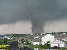 Photograph of Stoughton tornado (via NWS) | |
| Type | Tornado outbreak |
|---|---|
| Duration | August 18, 2005 |
| Tornadoes confirmed | 28 confirmed |
| Max rating1 | F3 tornado |
| Duration of tornado outbreak2 | 8 hours, 40 minutes |
| Damage | $42.537 million |
| Casualties | 1 fatality, 24 injuries |
| Areas affected | Minnesota, Wisconsin |
|
1Most severe tornado damage; see Fujita scale 2Time from first tornado to last tornado | |
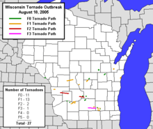
The August 2005 Wisconsin tornado outbreak was an outbreak of tornadoes that occurred primarily in southern Wisconsin on August 18, 2005. Another tornado touched down in Minnesota. A total of 27 tornadoes were confirmed that day in Wisconsin, the most tornadoes recorded in the state in a single day.[1] This broke the previous record of 24 tornadoes set on May 8, 1988. The system generating the Stoughton tornado was also accompanied by many reports of severe winds and hail throughout the region. The Stoughton tornado was documented on an episode of The Weather Channel's Storm Stories.[2]
Tornadoes
| F0 | F1 | F2 | F3 | F4 | F5 | Total |
|---|---|---|---|---|---|---|
| 11 | 14 | 2 | 1 | 0 | 0 | 28 |
August 18 event
| List of confirmed tornadoes - Thursday, August 18, 2005 | ||||||
|---|---|---|---|---|---|---|
| | | | | | ||
| Minnesota | ||||||
| F0 | N of Dexter | Mower | 1750–1751 | 0.1 miles (0.16 km) | A brief tornado damaged a single livestock barn and flattened part of a corn field.[3] | |
| Wisconsin | ||||||
| F0 | W of Centerville | Trempealeau | 1918–1919 | 0.1 miles (0.16 km) | Tornado knocked down several trees in a grove along its extremely short path.[4] | |
| F1 | W of Esofea | Vernon | 2046–2048 | 1.2 miles (1.9 km) | One mobile home, which was on cement blocks, was completely destroyed, injuring one person. Another residence had minor damage, where windows were blown out, outbuildings were destroyed and a car was turned 90 degrees. Power poles were snapped, corn was flattened, and significant tree damage occurred as well.[5] | |
| F2 | W of Liberty to W of Hub City | Vernon, Richland | 2105–2140 | 20 miles (32 km) | Considerable damage occurred in the village of Viola, with most homes in the village sustaining at least minor damage, while a few sustained major damage, including roofs blown off. Many garages facing west or southwest were destroyed by the direct impact of the winds. Almost every tree in town was damaged or downed, and three people were injured. Minor damage also occurred in rural areas and in Bloom City.[6][7] | |
| F1 | Muscoda to Orion | Grant, Richland | 2140 | 4 miles (6.4 km) | Tornado touched down in Muscoda, where many trees were downed and homes sustained minor damage. In Orion, the tornado damaged several mobile homes, some of which were tossed into the air.[8] | |
| F1 | Necedah area | Monroe, Juneau | 2154 | 2 miles (3.2 km) | There was tree, agricultural, and structural damage along the path. A home, which was under construction, was completely destroyed. Three other homes sustained minor damage. Corn was flattened and there was significant tree damage as well.[8] | |
| F0 | ENE of Avoca | Iowa | 2155 | 0.1 miles (0.16 km) | Minor trees damage occurred.[9] | |
| F1 | NNE of Clyde | Iowa, Sauk | 2218 | 6.5 miles (10.5 km) | Tornado damaged trees, power lines, and corn.[10] | |
| F1 | SSW of Spring Green | Sauk | 2230 | 1.9 miles (3.1 km) | Tornado damaged trees, power lines, and crops.[11] | |
| F0 | WSW of Wautoma | Waushara | 2232 | 2 miles (3.2 km) | Tornado snapped off and uprooted numerous trees, and caused damage to a few buildings and some farm equipment before dissipating. A tree fell onto a large pole building, causing major damage to one of its sides, and the porch at a residence was destroyed by a fallen tree limb. A portion of the metal roof of a barn was torn away and thrown about 200 feet. An irrigation system was damaged and a home suffered minor shingle damage as well.[12] | |
| F1 | S of Adams | Adams | 2239 | 0.75 miles (1.21 km) | Several mobile homes and trees were damaged.[13] | |
| F2 | NE of Leland to SE of Okee | Sauk, Columbia | 2240 | 10 miles (16 km) | Rain-wrapped tornado moved through old Badger Ammunition Plant grounds and damaged many structures, trees, and power-lines. As for residential buildings, 10 received minor damage, 1 had major damage, and one was destroyed. One business building had minor damage. As for agricultural buildings, 5 received minor damage, and 6 were destroyed. Damage in Columbia County was limited to trees, power lines, and crops.[14] | |
| F0 | W of Merrimac | Sauk | 2300 | 1 mile (1.6 km) | Tornado spotted along the Wisconsin River damaged trees and power lines.[15] | |
| F1 | NNE of Westfield | Marquette | 2308 | 5.5 miles (8.9 km) | On one property, a residential home sustained minor roof damage, and there was minor damage to two out-buildings and farm equipment/machinery. On another property, minor damage to a silo was noted. Extensive tree and power-line damage was reported along the entire path of the tornado.[16] | |
| F0 | NNE of Lodi | Columbia | 2310 | 0.1 miles (160 m) | Minor vegetative damage occurred.[17] | |
| F3 | N of Oregon to N of Busseyville | Dane, Jefferson | 2315 | 20 miles (32 km) | 1 death - See section on this tornado. | |
| F0 | WSW of Dane | Dane | 2317 | 2 miles (3.2 km) | Corn crop was damaged.[18] | |
| F0 | SW of New London | Waupaca | 2338 | 1.2 miles (1.9 km) | Tornado snapped off large trees and damaged a few buildings along its path. It shifted a large barn, and destroyed a small metal shed and threw it about a quarter mile. It also overturned an outbuilding and threw it 30 to 40 feet into a stand of trees. | |
| F0 | W of Neenah | Winnebago | 2340 | 4 miles (6.4 km) | Many trees were uprooted or snapped. The tornado ripped the siding from a home and flattened a corn crib.[19] | |
| F1 | SSW of Rockdale | Dane | 0010 | 1.6 miles (2.6 km) | Many large trees were uprooted or twisted, and minor damage was inflicted on 3 homes and one pole shed. In addition, power-lines were knocked down.[20] | |
| F0 | W of Fort Atkinson | Jefferson | 0010 | 0.5 miles (0.80 km) | Two mobile homes sustained minor damage. One residential home was also damaged and its 3-car garage was destroyed. One farm shed was destroyed, many large trees were uprooted, and minor crop damage was noted.[21] | |
| F1 | W of Fort Atkinson | Jefferson | 0020 | 0.7 miles (1.1 km) | A trailer with a truck inside was tipped over, resulting to damage to both. One residential home sustained minor damage, many large trees were uprooted or twisted, and minor crop damage was noted.[22] | |
| F1 | WSW of Fort Atkinson | Jefferson | 0027 | 1.2 miles (1.9 km) | One residential home sustained minor damage, two shed used for horses sustained roof and siding damage, many large trees were uprooted or twisted, and minor crop damage was noted.[23] | |
| F1 | Fort Atkinson area | Jefferson | 0037 | 1.4 miles (2.3 km) | This tornado moved due east through the southern part of the city of Fort Atkinson. Twenty residential homes and 5 businesses sustained minor damage, one business was destroyed, numerous many large trees were uprooted or twisted, some power-lines were damaged, and minor crop damage was noted. As for business losses, a portion of the roof of the Rock River Lanes was peeled back, the Best Western Motel had minor sign and roofing damage, and the Fort Plaza Mini Warehouse was destroyed.[24] | |
| F1 | SSW of Fort Atkinson | Jefferson | 0044 | 3 miles (4.8 km) | Tree damage and some minor crop damage was noted.[25] | |
| F0 | SE of Fort Atkinson | Jefferson | 0045 | 0.2 miles (320 m) | Several large trees were uprooted, one corn bin was ripped apart, and two other corn bins were damaged. Minor crop damage was noted as well.[26] | |
| F1 | NE of Wrightstown | Brown | 0045 | 1 mile (1.6 km) | About 75 trees were snapped or uprooted along the tornado path. Two wooden garages were destroyed, and the walls of a house under construction were blown down. A part of a steel roof was damaged, and a heavy wooden bench was lifted in the air and thrown several hundred feet away from the house.[27] | |
| F1 | SW of Manitowoc | Manitowoc | 0135 | 1.5 miles (2.4 km) | A farm was damaged and several dozen trees were snapped or uprooted. Several hay wagons and trailers were overturned, while a concrete silo was destroyed. One other silo was damaged, and the roof of a barn also sustained significant damage.[28] | |
Stoughton F3 tornado

By far the most significant tornado of the day developed 2.0 miles (3.2 km) north of Oregon at 6:15 p.m.. This large, intense multiple-vortex tornado tracked 20.0 miles (32.2 km) into Jefferson County from Dane County, devastating the town of Stoughton.
East of Oregon the tornado tore through several farms before impacting residential subdivisions in Stoughton. One person was crushed to death in their basement from fireplace and chimney bricks that crashed through the floor. Numerous homes, businesses, farm buildings, vehicles, power-lines, trees, and other personal effects were either damaged or destroyed along its path that grew to a maximum width of about 600 yards north of Stoughton. As for residential structures, 220 sustained minor damage, 84 had major damage, and 69 were destroyed. As for business structures, 6 sustained minor damage, 1 had major damage, and 1 was destroyed. As for agricultural structures, 5 sustained minor damage, 5 had major damage, and 40 were destroyed. Several vehicles were flipped and tossed as well.[29] Some homes in town were completely leveled, and an F4 rating was considered. Further investigation revealed that the homes were not well-built, and the slow (sometimes nearly stationary) forward movement of the tornado negated a rating higher than F3. After striking Stoughton, the tornado caused damage to trees and crops north of Busseyville before dissipating. Debris from this tornado was lofted by the parent updraft and carried downstream to scattered locations in the counties of Jefferson, Waukesha, Milwaukee, Walworth, Racine, and Kenosha. 23 people were injured.[30][31]
The Stoughton tornado struck on the day after a devastating fire at one of the city's largest churches (cause unrelated to severe weather) and was the climax of a two-day spate of severe weather in Southern Wisconsin; the previous day several superbolts of lightning were reported as having done extensive damage at various sites in Madison and other Dane County communities, including one incident in which a tree many feet in diameter literally exploded when hit by a bolt apparently from a storm 7–10 miles away and with the sun shining at the location at the time.
Ten years later to the day, three tornadoes touched down outside of Lake Geneva, Big Bend, and Waukesha. There were no injuries or fatalities from those tornadoes.[32][33]
See also
- List of North American tornadoes and tornado outbreaks
- Tornadoes of 2005
- Southern Ontario tornado outbreak of 2005 – An outbreak the following day produced by the same area of low pressure.
References
- ↑ National Weather Service Milwaukee/Sullivan (2005-08-27). "Record Tornado Outbreak, August 18, 2005". Record Tornado Outbreak, August 18, 2005. National Weather Service. Archived from the original on 4 June 2011. Retrieved 2011-06-07.
- ↑ http://www.imdb.com/title/tt0992652/?ref_=ttep_ep1
- ↑ Minnesota Event Report: F0 Tornado (Report). National Climatic Data Center. National Weather Service Weather Forecast Office in La Crosse, Wisconsin. 2005. Retrieved March 5, 2016.
- ↑ Wisconsin Event Report: F0 Tornado (Report). National Climatic Data Center. National Weather Service Weather Forecast Office in La Crosse, Wisconsin. 2005. Retrieved March 5, 2016.
- ↑ Wisconsin Event Report: F1 Tornado (Report). National Climatic Data Center. National Weather Service Weather Forecast Office in La Crosse, Wisconsin. 2005. Retrieved March 5, 2016.
- ↑ Wisconsin Event Report: F2 Tornado (Report). National Climatic Data Center. National Weather Service Weather Forecast Office in La Crosse, Wisconsin. 2005. Retrieved March 5, 2016.
- ↑ Wisconsin Event Report: F2 Tornado (Report). National Climatic Data Center. National Weather Service Weather Forecast Office in La Crosse, Wisconsin. 2005. Retrieved March 5, 2016.
- 1 2 http://www.ncdc.noaa.gov/stormevents/eventdetails.jsp?id=5473495
- ↑ http://www.ncdc.noaa.gov/stormevents/eventdetails.jsp?id=5475616
- ↑ http://www.ncdc.noaa.gov/stormevents/eventdetails.jsp?id=5475615
- ↑ http://www.ncdc.noaa.gov/stormevents/eventdetails.jsp?id=5475701
- ↑ http://www.ncdc.noaa.gov/stormevents/eventdetails.jsp?id=5476451
- ↑ http://www.ncdc.noaa.gov/stormevents/eventdetails.jsp?id=5473497
- ↑ http://www.ncdc.noaa.gov/stormevents/eventdetails.jsp?id=5475703
- ↑ http://www.ncdc.noaa.gov/stormevents/eventdetails.jsp?id=5475704
- ↑ http://www.ncdc.noaa.gov/stormevents/eventdetails.jsp?id=5475740
- ↑ http://www.ncdc.noaa.gov/stormevents/eventdetails.jsp?id=5475741
- ↑ http://www.ncdc.noaa.gov/stormevents/eventdetails.jsp?id=5475743
- ↑ http://www.ncdc.noaa.gov/stormevents/eventdetails.jsp?id=5476453
- ↑ http://www.ncdc.noaa.gov/stormevents/eventdetails.jsp?id=5475793
- ↑ http://www.ncdc.noaa.gov/stormevents/eventdetails.jsp?id=5475795
- ↑ http://www.ncdc.noaa.gov/stormevents/eventdetails.jsp?id=5475796
- ↑ http://www.ncdc.noaa.gov/stormevents/eventdetails.jsp?id=5475797
- ↑ http://www.ncdc.noaa.gov/stormevents/eventdetails.jsp?id=5475842
- ↑ http://www.ncdc.noaa.gov/stormevents/eventdetails.jsp?id=5475844
- ↑ http://www.ncdc.noaa.gov/stormevents/eventdetails.jsp?id=5475843
- ↑ http://www.ncdc.noaa.gov/stormevents/eventdetails.jsp?id=5476454
- ↑ http://www.ncdc.noaa.gov/stormevents/eventdetails.jsp?id=5476454?
- ↑ "Record Tornado Outbreak August 18, 2005". NWS Milwaukee. NOAA. February 10, 2010. Retrieved January 17, 2014.
- ↑ "Storm Events Database". NCDC. NCDC. Retrieved January 17, 2014.
- ↑ "Storm Events Database". NCDC. NCDC. Retrieved January 17, 2014.
- ↑ http://www.jsonline.com/weather/tornado-suspected-of-leaving-trail-of-damage-near-lake-geneva-b99560092z1-322270271.html
- ↑ http://www.jsonline.com/weather/third-tornado-confirmed-from-tuesdays-storms-b99560973z1-322422071.html
External links
- Stoughton Tornado Website (Jonathon G. Lampe)
- National Weather Service Milwaukee report
- NWS La Crosse report
- Photos from spotter organization MidWest SSTRC. (Dale Bernstein-President, and Dan H.)
- Video about The Tornado and Church Fire from Stoughton's Public, educational, and government access cable TV channel