Viola, Wisconsin
| Viola, Wisconsin | |
|---|---|
| Village | |
|
Viola Community Center | |
 Location in Vernon County and the state of Wisconsin. | |
| Coordinates: 43°30′27″N 90°40′13″W / 43.50750°N 90.67028°WCoordinates: 43°30′27″N 90°40′13″W / 43.50750°N 90.67028°W | |
| Country | United States |
| State | Wisconsin |
| Counties | Richland, Vernon |
| Area[1] | |
| • Total | 1.02 sq mi (2.64 km2) |
| • Land | 1.00 sq mi (2.59 km2) |
| • Water | 0.02 sq mi (0.05 km2) |
| Elevation[2] | 764 ft (233 m) |
| Population (2010)[3] | |
| • Total | 699 |
| • Estimate (2012[4]) | 693 |
| • Density | 699.0/sq mi (269.9/km2) |
| Time zone | Central (CST) (UTC-6) |
| • Summer (DST) | CDT (UTC-5) |
| Area code(s) | 608 |
| FIPS code | 55-82900[5] |
| GNIS feature ID | 1576108[2] |
| Website | http://www.vi.viola.wi.gov/ |

Viola is a village in Richland (mostly) and Vernon Counties in the U.S. state of Wisconsin, United States. The population was 699 at the 2010 census. Of this, 477 were in Richland County, and 222 were in Vernon County.
Geography
Viola is located at 43°30′27″N 90°40′13″W / 43.50750°N 90.67028°W (43.507552, -90.670178).[6]
According to the United States Census Bureau, the village has a total area of 1.02 square miles (2.64 km2), of which, 1.00 square mile (2.59 km2) of it is land and 0.02 square miles (0.05 km2) is water.[1] The zip code is 54664.
Demographics
| Historical population | |||
|---|---|---|---|
| Census | Pop. | %± | |
| 1900 | 432 | — | |
| 1910 | 671 | 55.3% | |
| 1920 | 858 | 27.9% | |
| 1930 | 699 | −18.5% | |
| 1940 | 825 | 18.0% | |
| 1950 | 785 | −4.8% | |
| 1960 | 721 | −8.2% | |
| 1970 | 659 | −8.6% | |
| 1980 | 696 | 5.6% | |
| 1990 | 644 | −7.5% | |
| 2000 | 667 | 3.6% | |
| 2010 | 699 | 4.8% | |
| Est. 2015 | 676 | [7] | −3.3% |
2010 census
As of the census[3] of 2010, there were 699 people, 279 households, and 184 families residing in the village. The population density was 699.0 inhabitants per square mile (269.9/km2). There were 331 housing units at an average density of 331.0 per square mile (127.8/km2). The racial makeup of the village was 98.6% White, 0.6% African American, 0.3% from other races, and 0.6% from two or more races. Hispanic or Latino of any race were 0.6% of the population.
There were 279 households of which 30.8% had children under the age of 18 living with them, 50.2% were married couples living together, 11.5% had a female householder with no husband present, 4.3% had a male householder with no wife present, and 34.1% were non-families. 27.2% of all households were made up of individuals and 13.3% had someone living alone who was 65 years of age or older. The average household size was 2.51 and the average family size was 3.06.
The median age in the village was 37.8 years. 27.2% of residents were under the age of 18; 7.7% were between the ages of 18 and 24; 23% were from 25 to 44; 25.1% were from 45 to 64; and 16.9% were 65 years of age or older. The gender makeup of the village was 47.9% male and 52.1% female.
2000 census
As of the census[5] of 2000, there were 667 people, 290 households, and 185 families residing in the village. The population density was 632.9 people per square mile (245.3/km²). There were 319 housing units at an average density of 302.7 per square mile (117.3/km²). The racial makeup of the village was 98.95% White, 0.15% Native American, 0.30% Asian, 0.15% from other races, and 0.45% from two or more races. Hispanic or Latino of any race were 1.20% of the population.
There were 290 households out of which 24.8% had children under the age of 18 living with them, 49.7% were married couples living together, 9.7% had a female householder with no husband present, and 35.9% were non-families. 31.0% of all households were made up of individuals and 16.9% had someone living alone who was 65 years of age or older. The average household size was 2.30 and the average family size was 2.88.
In the village the population was spread out with 22.0% under the age of 18, 8.4% from 18 to 24, 23.7% from 25 to 44, 24.0% from 45 to 64, and 21.9% who were 65 years of age or older. The median age was 43 years. For every 100 females there were 92.8 males. For every 100 females age 18 and over, there were 85.7 males.
The median income for a household in the village was $28,068, and the median income for a family was $34,286. Males had a median income of $28,583 versus $17,188 for females. The per capita income for the village was $17,265. About 12.9% of families and 16.9% of the population were below the poverty line, including 27.5% of those under age 18 and 9.4% of those age 65 or over.
Education
- The Kickapoo High School is the local public high school.
Notable people
- Frank J. Cosgrove, Wisconsin politician, farmer, and businessman, was born in Viola.[9]
- Robert H. DeLap, Wisconsin politician, soldier, and physician, lived in Viola.[10]
- Russel B. Nye, educator, historian and 1945 Pulitzer Prize-winning author, was born in Viola.[11]
References
- 1 2 "US Gazetteer files 2010". United States Census Bureau. Retrieved 2012-11-18.
- 1 2 "US Board on Geographic Names". United States Geological Survey. 2007-10-25. Retrieved 2008-01-31.
- 1 2 "American FactFinder". United States Census Bureau. Retrieved 2012-11-18.
- ↑ "Population Estimates". United States Census Bureau. Retrieved 2013-06-24.
- 1 2 "American FactFinder". United States Census Bureau. Retrieved 2008-01-31.
- ↑ "US Gazetteer files: 2010, 2000, and 1990". United States Census Bureau. 2011-02-12. Retrieved 2011-04-23.
- ↑ "Annual Estimates of the Resident Population for Incorporated Places: April 1, 2010 to July 1, 2015". Retrieved July 2, 2016.
- ↑ "Census of Population and Housing". Census.gov. Retrieved June 4, 2015.
- ↑ 'Wisconsin Blue Book 1960.' Biographical Sketch of Frank J. Cosgrove, pg. 35
- ↑ THE BLUE BOOK OF THE STATE OF WISCONSIN. 1889. p. 516-517.
- ↑ 'Russel Nye, Historian, Dies at 80; A Student of Comics, Jazz and TV,' New York Times, Bruce Lambert, September 5, 1993
External links
| Wikimedia Commons has media related to Viola, Wisconsin. |
Municipalities and communities of Richland County, Wisconsin, United States | ||
|---|---|---|
| City | 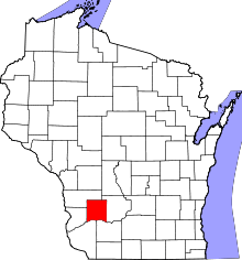 | |
| Villages | ||
| Towns | ||
| CDPs | ||
| Unincorporated communities |
| |
| Ghost towns | ||
| Footnotes | ‡This populated place also has portions in an adjacent county or counties | |
Municipalities and communities of Vernon County, Wisconsin, United States | ||
|---|---|---|
| Cities | 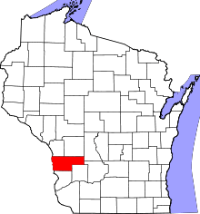 | |
| Villages | ||
| Towns | ||
| Unincorporated communities | ||
| Footnotes | ‡This populated place also has portions in an adjacent county or counties | |