Baicheng

Baicheng (Chinese: 白城; pinyin: Báichéng; literally: "White City") is a prefecture-level city in the northwestern part of Jilin province, People's Republic of China, bordering Inner Mongolia to the north and west and Heilongjiang to the east and northeast. At the 2010 census, 2,033,058 people resided within its administrative area of 25,683 km2 (9,916 sq mi).[1]
History
The area around present day Baicheng was a nomadic area which was inhabited by several nomad tribes in Northeast China as early as the Late Neolithic Age, including the Eastern Hu, the Xianbei, the Fuyu, and the Khitans once inhabited the area. During the Liao Dynasty, Baicheng was the political center of four emperors, including Emperor Shengzong, Emperor Xingzong, Emperor Daozong, and Emperor Tianzuo, as the seat of the local government was located at Chengsijiazi Ancient fort in today's Taobei District. As Qing Government forsook the settlement of Han Chinese in the 19th century, no farming was allowed until 1902. In 1904 Baicheng became a county going by the name of Jing'an (靖安). In 1914 Jing'an County was renamed Tao'an (洮南). By 1938 it was finally renamed Baicheng, which in Chinese means white town. The name's origin is the Mongolian name of the city Chaghanhot, which also means "white town".[2] Baicheng used to belong to Nenjiang and Heilongjiang province, under the jurisdiction of the former provincial capital Qiqihar. In 1954, with the Heilongjiang Province merged with Songjiang Province, Baicheng was incorporated into Jilin Province.
Baicheng's importance started to increase after a railway from Qiqihar to Siping through Baicheng was constructed in the 1920s. In the 1930s another railway connecting Baicheng to Ulanhot and the mines at Arxan was opened northwestward. These two lines enabled Baicheng to become a regional transportation hub in western Jilin Province. One more rail line connecting Changchun was opened in the mid-1930s as well.[3]
Geography
Topography
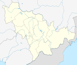
Baicheng is located in the eastern part of the Horqin Grassland, and situated in the northwestern part of Jilin Province. Bordering prefecture cities are:
- Songyuan (SE)
- Qiqihar (N)
- Xingan League (W)
The city's metro area is located 333 kilometres (207 mi) from the provincial capital of Changchun, 218 kilometres (135 mi) from Qiqihar, 448 kilometres (278 mi) from Siping, and 83 kilometres (52 mi) from Ulanhot. The city is located at latitude 44° 13′—46° 18′ N and longitude 121° 38′—124° 22' E. At its greatest width, the city spans 230 kilometres (142.9 mi) from north to south and 211 kilometres (131 mi) from east to west. The total area of the city is 25,683 square kilometres (9,916 sq mi), occupying a mere 13.7% of the provincial area. The eastern part of the Greater Khingan Mountains lies in the northwest of Baicheng. Grassland and wetlands are prominent throughout the city's southeastern part.
Climate
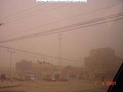
Baicheng has a rather dry, monsoon-influenced, humid continental climate (Köppen Dwa), with long (lasting from November to March), very cold, windy, but dry winters due to the influence of the Siberian high, and hot, humid summers, due to the East Asian monsoon. The coldest month, January, averages −16.4 °C (2.5 °F), while the warmest month, July, averages 23.4 °C (74.1 °F); the annual mean is 5.04 °C (41.1 °F). More than 70% of the annual precipitation falls from June to August alone. Drought conditions are common in spring and autumn; from 1961 to 2009, there were 31 years with spring drought and 28 with autumn drought.[4]
| Climate data for Baicheng (1971−2000) | |||||||||||||
|---|---|---|---|---|---|---|---|---|---|---|---|---|---|
| Month | Jan | Feb | Mar | Apr | May | Jun | Jul | Aug | Sep | Oct | Nov | Dec | Year |
| Record high °C (°F) | 5.9 (42.6) |
12.8 (55) |
24.3 (75.7) |
31.2 (88.2) |
38.1 (100.6) |
38.6 (101.5) |
37.3 (99.1) |
37.7 (99.9) |
31.7 (89.1) |
29.8 (85.6) |
17.5 (63.5) |
7.2 (45) |
38.6 (101.5) |
| Average high °C (°F) | −9.1 (15.6) |
−4.1 (24.6) |
4.3 (39.7) |
14.9 (58.8) |
22.5 (72.5) |
26.9 (80.4) |
28.5 (83.3) |
27.2 (81) |
21.7 (71.1) |
13.0 (55.4) |
1.3 (34.3) |
−6.9 (19.6) |
11.7 (53.1) |
| Daily mean °C (°F) | −16.4 (2.5) |
−11.7 (10.9) |
−2.7 (27.1) |
7.6 (45.7) |
15.7 (60.3) |
20.9 (69.6) |
23.4 (74.1) |
21.5 (70.7) |
14.9 (58.8) |
6.0 (42.8) |
−5.1 (22.8) |
−13.6 (7.5) |
5.04 (41.07) |
| Average low °C (°F) | −22.4 (−8.3) |
−18.3 (−0.9) |
−10.1 (13.8) |
−0.1 (31.8) |
8.2 (46.8) |
14.8 (58.6) |
18.3 (64.9) |
16.0 (60.8) |
8.4 (47.1) |
−0.3 (31.5) |
−10.6 (12.9) |
−19 (−2) |
−1.3 (29.7) |
| Record low °C (°F) | −38.1 (−36.6) |
−30.3 (−22.5) |
−26 (−15) |
−13.6 (7.5) |
−4.4 (24.1) |
3.7 (38.7) |
8.7 (47.7) |
7.1 (44.8) |
−2.9 (26.8) |
−19.6 (−3.3) |
−29.3 (−20.7) |
−35.1 (−31.2) |
−38.1 (−36.6) |
| Average precipitation mm (inches) | 0.5 (0.02) |
1.2 (0.047) |
4.5 (0.177) |
13.7 (0.539) |
27.6 (1.087) |
80.8 (3.181) |
130.6 (5.142) |
82.0 (3.228) |
37.3 (1.469) |
15.4 (0.606) |
3.2 (0.126) |
1.6 (0.063) |
398.4 (15.685) |
| Average precipitation days | 1.4 | 2.0 | 2.9 | 3.9 | 6.8 | 11.3 | 12.5 | 10.5 | 7.4 | 4.0 | 2.6 | 2.5 | 67.8 |
| Source: [4] | |||||||||||||
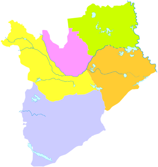
Administrative divisions
| Map | ||||||
|---|---|---|---|---|---|---|
| # | Name | Hanzi | Hanyu Pinyin | Population (2003 est.) | Area (km²) | Density (/km²) |
| 1 | Taobei District | 洮北区 | Táoběi Qū | 490,000 | 2,525 | 194 |
| 2 | Da'an City | 大安市 | Dà'ān Shì | 420,000 | 4,879 | 86 |
| 3 | Taonan City | 洮南市 | Táonán Shì | 440,000 | 5,108 | 86 |
| 4 | Zhenlai County | 镇赉县 | Zhènlài Xiàn | 310,000 | 4,695 | 66 |
| 5 | Tongyu County | 通榆县 | Tōngyú Xiàn | 350,000 | 8,476 | 41 |
Economy
Textile industry is one of the main pillars of the economy. Agriculture of the area is centred on plantation of soy beans and oil plants.
Transportation
Railway

Baicheng railway station is a railway hub in western Jilin Province. There are multiple daily departures to other cities including Beijing, Harbin, Changchun, Shenyang, Dalian, Qiqihar, Ulanhot and several other cities in northern provinces of China.
Air
Baicheng Chang'an Airport has been under construction since October 26, 2012.[5]
Sister cities
References
- 1 2 2010年吉林省第六次全国人口普查主要数据公报(Sixth National Population Census of the People's Republic of China)
- ↑ 白城市地方志编纂委员会编 (1993). 白城市志 History of Baicheng. 中国广播电视出版社. ISBN 7-5043-2568-6.
- ↑ Encyclopedia Britannica:Baicheng http://www.britannica.com/EBchecked/topic/438371/Baicheng
- 1 2 Weather.com.cn. Accessed 2011-05-28.
- ↑ "白城新空港:长安机场" [A Baicheng Airport: Changan airport]. Government of Jilin Province. 2012-10-30. Archived from the original on 2013-02-15. Retrieved 2013-01-22.
External links
| Wikimedia Commons has media related to Baicheng. |
| Wikivoyage has a travel guide for Baicheng. |