Shuangyang District
| Shuangyang 双阳区 | |||||||||||||||||||||||||||||||||
|---|---|---|---|---|---|---|---|---|---|---|---|---|---|---|---|---|---|---|---|---|---|---|---|---|---|---|---|---|---|---|---|---|---|
| District | |||||||||||||||||||||||||||||||||
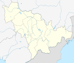 Shuangyang Location in Jilin | |||||||||||||||||||||||||||||||||
| Coordinates: 43°31′30″N 125°40′08″E / 43.5249°N 125.6688°ECoordinates: 43°31′30″N 125°40′08″E / 43.5249°N 125.6688°E[1] | |||||||||||||||||||||||||||||||||
| Country | People's Republic of China | ||||||||||||||||||||||||||||||||
| Province | Jilin | ||||||||||||||||||||||||||||||||
| Sub-provincial city | Changchun | ||||||||||||||||||||||||||||||||
| Area[2] | |||||||||||||||||||||||||||||||||
| • Total | 1,677 km2 (647 sq mi) | ||||||||||||||||||||||||||||||||
| Population (2010)[3] | |||||||||||||||||||||||||||||||||
| • Total | 377,803 | ||||||||||||||||||||||||||||||||
| • Density | 230/km2 (580/sq mi) | ||||||||||||||||||||||||||||||||
| Time zone | China Standard (UTC+8) | ||||||||||||||||||||||||||||||||
| Postal code | 1306XX | ||||||||||||||||||||||||||||||||
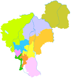
| Changchun district map |
| ||||||||||||||||||||||||||||||||
Shuangyang District (simplified Chinese: 双阳区; traditional Chinese: 雙陽區; pinyin: Shuāngyáng Qū) is one of six districts of Changchun, the capital of Jilin province, People's Republic of China, forming part of the city's southeastern suburbs. Despite its name, it lies more than 40 kilometres (25 mi) southeast of the urban centre. It borders the districts of Erdao to the north and Nanguan to the northwest, as well as the prefecture-level cities of Jilin to the south and east and Siping to the southwest.
Administrative divisions
There are 4 subdistricts, 4 towns, and 1 ethnic township.[4]
Subdistricts:
- Pinghu Subdistrict (平湖街道), Yunshan Subdistrict (云山街道), Sheling Subdistrict (奢岭街道), Shanhe Subdistrict (山河街道)
Towns:
- Taiping (太平镇), Luxiang (鹿乡镇), Tuding (土顶镇), Qijia (齐家镇)
The only township is Shuangyingzi Hui Ethnic Township (双营子回族乡)
References
- ↑ Google (2014-07-02). "Shuangyang" (Map). Google Maps. Google. Retrieved 2014-07-02.
- ↑ Changchun Statistical Yearbook 2011 (《长春统计年鉴2011》). Accessed 8 July 2014.
- ↑ 2010 Census county-by-county statistics (《中国2010年人口普查分县资料》). Accessed 8 July 2014.
- ↑ 长春市-行政区划网 www.xzqh.org
This article is issued from Wikipedia - version of the 10/14/2016. The text is available under the Creative Commons Attribution/Share Alike but additional terms may apply for the media files.