Baihata
| Baihata Chariali বাইহাটা চাৰিআলি Baihata Chariali | |
|---|---|
| Town | |
| Nickname(s): Baihata Chariali | |
 Baihata Chariali  Baihata Chariali Location in Assam, India | |
| Coordinates: 26°20′42″N 91°43′35″E / 26.3451°N 91.7264°ECoordinates: 26°20′42″N 91°43′35″E / 26.3451°N 91.7264°E | |
| Country |
|
| State | Assam |
| District | Kamrup |
| Elevation | 46 m (151 ft) |
| Languages | |
| • Official | Assamese |
| Time zone | IST (UTC+5:30) |
| PIN | 781381 |
| ISO 3166 code | IN-AS |
| Vehicle registration | AS |
| Website |
kamrup |
Baihata Chariali (Pron: baɪˈhɑ:tə ˈʧɑ:rɪˌɑ:lɪ) is a town in Kamrup Rural district of Assam, situated on north bank of river Brahmaputra.[1][2][3]
Place of interest
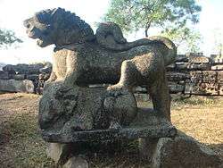
Madan Kamdev archeological site built by Pala dynasty of Kamrup Kingdom is located here. The famous Gopeshwar temple is situated in village Deuduar near to Baihata Chariali.
Transport
Baihata Chariali is at National Highway 31 and is well connected with nearby towns like Rangia, Nalbari and Guwahati with road and Railways. It is about half hour away from Guwahati.
See also
References
This article is issued from Wikipedia - version of the 10/21/2016. The text is available under the Creative Commons Attribution/Share Alike but additional terms may apply for the media files.