Baker City
| Baker City, Oregon | |
|---|---|
| City | |
|
Main Street | |
| Motto: "On the Historic Oregon Trail." | |
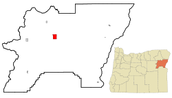 Location in Oregon | |
 Baker City along I-84 in Oregon, surrounded by sections of Wallowa–Whitman National Forest. | |
| Coordinates: 44°46′30″N 117°50′04″W / 44.77500°N 117.83444°WCoordinates: 44°46′30″N 117°50′04″W / 44.77500°N 117.83444°W | |
| Country | United States |
| State | Oregon |
| County | Baker |
| Platted | 1865[1] |
| Incorporated | 1874[1] |
| Government | |
| • Mayor | Kim Mosier |
| Area[2] | |
| • Total | 7.16 sq mi (18.54 km2) |
| • Land | 7.16 sq mi (18.54 km2) |
| • Water | 0 sq mi (0 km2) |
| Elevation | 3,451 ft (1,052 m) |
| Population (2010)[3] | |
| • Total | 9,828 |
| • Estimate (2013)[4] | 9,769 |
| • Density | 1,400/sq mi (530/km2) |
| Time zone | Pacific (UTC-8) |
| • Summer (DST) | Pacific (UTC-7) |
| ZIP code | 97814 |
| Area code(s) | 541 |
| FIPS code | 41-03650 |
| GNIS feature ID | 1167694 [5] |
| Website | City Website |
| Coordinates are from the Geographic Names Information System.[5] | |

Baker City is a city in and the county seat of Baker County, Oregon, United States. It was named after Edward D. Baker, the only U.S. Senator ever killed in military combat. The population was 9,828 at the 2010 census.
History
Platted in 1865,[1] Baker City grew slowly in the beginning.[6] A post office was established on March 27, 1866, but Baker City was not incorporated until 1874.[1] Even so, it supplanted Auburn as the county seat in 1868.[7] The city[1] and county were named in honor of U.S. Senator Edward D. Baker, the only sitting senator to be killed in a military engagement. He died in 1861 while leading a charge of 1,700 Union Army soldiers up a ridge at Ball's Bluff, Virginia, during the American Civil War.[8][9]
The Oregon Short Line Railroad came to Baker City in 1884, prompting growth; by 1900 it was the largest city between Salt Lake City and Portland and a trading center for a broad region.[1] In 1911 the city dropped "City" from its name, but restored it in 1989.[10]
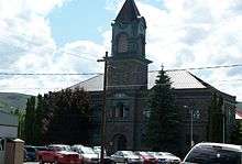
The Roman Catholic Diocese of Baker was established on June 19, 1903, after which the Cathedral of Saint Francis de Sales was built in Baker City.[11] In 1918, Baker was the subject of national interest when the 1918 solar eclipse took place and the U.S. Naval Observatory based its observations there.[12] The path of totality of the upcoming solar eclipse of August 21, 2017 includes Baker City as well.[13]
Geography
According to the United States Census Bureau, the city has a total land area of 7.16 square miles (18.54 km2).[2]
The city is situated in a valley between the Wallowa Mountains to the east and the Elkhorn Mountains, part of the Blue Mountains to the west, with the Powder River running through the center of downtown on its way to the Snake River.
Climate
Baker City has a cold semi-arid climate (Köppen BSk). July and August are generally the hottest months, when the high temperatures average 84.5 °F (29.2 °C).[14] The highest recorded temperature, 106 °F (41 °C), occurred on August 4, 1961.[14] December and January are usually the coldest months, when lows average 17 °F (−8 °C).[14] In December 1978, the temperature fell to −39 °F (−39 °C), the lowest recorded in the city.[14] May is typically the month of highest precipitation, averaging 1.48 inches (38 mm).[14] Snowfall averages about 25 inches (64 cm) a year.[15]
| Climate data for Baker City, Oregon | |||||||||||||
|---|---|---|---|---|---|---|---|---|---|---|---|---|---|
| Month | Jan | Feb | Mar | Apr | May | Jun | Jul | Aug | Sep | Oct | Nov | Dec | Year |
| Record high °F (°C) | 59 (15) |
66 (19) |
78 (26) |
89 (32) |
94 (34) |
102 (39) |
103 (39) |
106 (41) |
101 (38) |
89 (32) |
72 (22) |
60 (16) |
106 (41) |
| Average high °F (°C) | 34.4 (1.3) |
41.7 (5.4) |
51.0 (10.6) |
59.2 (15.1) |
67.0 (19.4) |
75.2 (24) |
84.5 (29.2) |
84.9 (29.4) |
75.5 (24.2) |
62.7 (17.1) |
44.9 (7.2) |
35.3 (1.8) |
59.69 (15.39) |
| Average low °F (°C) | 17.0 (−8.3) |
22.1 (−5.5) |
27.1 (−2.7) |
31.3 (−0.4) |
38.3 (3.5) |
44.3 (6.8) |
48.4 (9.1) |
47.4 (8.6) |
39.0 (3.9) |
30.3 (−0.9) |
24.4 (−4.2) |
17.4 (−8.1) |
32.25 (0.15) |
| Record low °F (°C) | −30 (−34) |
−28 (−33) |
−5 (−21) |
12 (−11) |
17 (−8) |
26 (−3) |
30 (−1) |
27 (−3) |
17 (−8) |
9 (−13) |
−16 (−27) |
−39 (−39) |
−39 (−39) |
| Average precipitation inches (mm) | 0.91 (23.1) |
0.63 (16) |
0.83 (21.1) |
0.86 (21.8) |
1.35 (34.3) |
1.24 (31.5) |
0.69 (17.5) |
0.87 (22.1) |
0.73 (18.5) |
0.57 (14.5) |
0.97 (24.6) |
0.95 (24.1) |
10.6 (269.1) |
| Average snowfall inches (cm) | 6.6 (16.8) |
4.1 (10.4) |
2.8 (7.1) |
1.1 (2.8) |
0.4 (1) |
0 (0) |
0 (0) |
0 (0) |
0 (0) |
0.2 (0.5) |
4.0 (10.2) |
7.4 (18.8) |
26.6 (67.6) |
| Average precipitation days (≥ 0.01 inch) | 11.7 | 9.4 | 9.7 | 9.3 | 10.0 | 7.9 | 4.9 | 5.0 | 4.8 | 5.8 | 11.3 | 11.0 | 100.8 |
| Average snowy days (≥ 0.1 inch) | 8.2 | 5.6 | 4.1 | 2.2 | 0.4 | 0 | 0 | 0 | 0 | 0.4 | 4.8 | 8.2 | 33.9 |
| Source: National Oceanic and Atmospheric Administration[14] | |||||||||||||
Demographics
| Historical population | |||
|---|---|---|---|
| Census | Pop. | %± | |
| 1870 | 312 | — | |
| 1880 | 1,258 | 303.2% | |
| 1890 | 2,604 | 107.0% | |
| 1900 | 6,663 | 155.9% | |
| 1910 | 6,742 | 1.2% | |
| 1920 | 7,729 | 14.6% | |
| 1930 | 7,858 | 1.7% | |
| 1940 | 9,342 | 18.9% | |
| 1950 | 9,471 | 1.4% | |
| 1960 | 9,986 | 5.4% | |
| 1970 | 9,354 | −6.3% | |
| 1980 | 9,471 | 1.3% | |
| 1990 | 9,140 | −3.5% | |
| 2000 | 9,860 | 7.9% | |
| 2010 | 9,828 | −0.3% | |
| Est. 2015 | 9,752 | [16] | −0.8% |
| Sources:[17] 2013 Estimate[4] | |||
2010 census
As of the census of 2010, there were 9,828 people, 4,212 households, and 2,529 families residing in the city. The population density was 1,372.1 people per square mile (529.8/km²). There were 4,653 housing units at an average density of 674.3 per square mile (259.9/km²). The racial makeup of the city was 94.57% White, 1.12% Native American, 0.53% Asian, 0.44% African American, 0.01% Pacific Islander, 0.97% from other races, and 2.35% from two or more races. Hispanic or Latino of any race were 3.52% of the population.
There were 4,212 households of which 24.5% had children under the age of 18 living with them, 45.1.2% were married couples living together, 10.5% had a female householder with no husband present, and 40.0% were non-families. 33.8% of all households were made up of individuals and 16.8% had someone living alone who was 65 years of age or older. The average household size was 2.25 and the average family size was 2.85. In the city the population was 23.7% under the age of 19, 5.0% from 20 to 24, 23.0% from 25 to 44, 27.8% from 45 to 64, and 20.5% who were 65 years of age or older. The median age was 44 years. For every 100 females there were 98.9 males. For every 100 females age 18 and over, there were 98.6 males. In 2005, the median income for a household in the city was $29,020, and the median income for a family was $34,790. Males had a median income of $26,638 versus $20,313 for females. The per capita income for the city was $14,179. About 10.7% of families and 16.5% of the population were below the poverty line, including 19.1% of those under age 18 and 14.9% of those age 65 or over.
Arts and culture
Annual events
Baker City hosts many annual festivals, including the Miners' Jubilee on the third weekend of July, which celebrates the mining history of the area and the filming of the 1969 Lee Marvin and Clint Eastwood musical comedy Paint Your Wagon in the city.[19] The Miners' Jubilee was originally launched in 1934 as the Baker Mining Jubilee, but lapsed after 1941 because of World War II and a declining interest in mining. The event was revived by Richard and Marge Haynes in 1975. The couple organized the celebration for two years before handing it over to the Baker County Chamber of Commerce.[20]
Museums and other points of interest
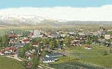
The Baker Historic District, on the National Register of Historic Places, is located on about 42 acres (17 ha) centered on Main Street in downtown Baker City. Within its boundaries are more than 130 properties, about half of which include structures built between the late 1880s and about 1915. Many of these as well as others built as early as 1870 are two-story masonry commercial buildings. The city hall, county courthouse, the former post office, former library, former social clubs, a Roman Catholic cathedral, and an Episcopal Church are among notable buildings within the district.[21]
Baker City Tower, a nine-story structure in the historic district, is the tallest building east of the Cascade Range in Oregon.[22] Opening in 1929 as the Baker Community Hotel, it was converted to other uses after financial setbacks during the Great Depression.[23] The concrete Art Deco structure features terracotta eagles at each ground-floor entrance and is topped by an octagonal observation center with an eight-sided hip roof and a flagpole.[22]
Also in the historic district is the Geiser Grand Hotel, a three-story, stucco-clad, brick structure that at the time of its opening in 1889 had plate glass windows, electric lights, baths, an elevator, and a dining room that seated 200. Originally called the Washauer Hotel, it became the Geiser Grand in about 1895 after its purchase by the John Geiser family, which had large mining investments in Baker County and elsewhere.[24]
Baker Heritage Museum, previously the Oregon Trail Regional Museum, is housed in the Natatorium built in 1920 on Grove street across from the city park. Enjoy exhibits interpreting the rich history of the region including mining, ranching, timber, early Baker City life, Chinese culture, and wildlife. Make sure to stop by the Adler House Museum, the home of Leo Adler is now the Baker Heritage Museum's largest artifact. Learn the amazing story of Leo Adler, Baker City philanthropist who donated millions to the people of Baker County in his will. The Adler house has been restored to his original splendor with original furnishings and interiors.
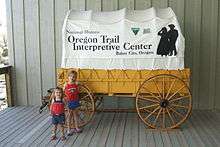
The National Historic Oregon Trail Interpretive Center, about 5 miles (8.0 km) east of the city, offers exhibits, theater performances, workshops, and other events and activities related to the Oregon Trail, the ruts of which pass through the center's 500-acre (200 ha) site.[25] Established in 1992,[1] the site is managed by the federal Bureau of Land Management and Trail Tenders, a group of volunteers.[25]
Other points of interest in Baker City include the Crossroads Art Center, in a former Carnegie library;[26] the downtown U.S. Bank, featuring a gold display that includes the Armstrong Nugget, weighing 80.4 ounces (2.28 kg);[27] the Eltrym, Baker City's only movie theater, housed in a single-story structure built in the late 1940s.[28]
Sports and recreation
The Baker City Cycling Classic is a set of bicycle races held in Baker City and the surrounding region.[29] Similar bicycle races, the Elkhorn Classic, were based in Baker City through 2011.[30] The city hosts the Oregon School Activities Association Class 1A girls and boys basketball tournaments at Baker High School in March.[31] The Oregon East−West Shrine Game (high school football) is held here in July.[32] The Hell's Canyon Motorcycle Rally is also held in Baker City, in June.[33]
Sections of the Wallowa–Whitman National Forest are to the west and to the northeast of Baker City, which serves as the forest headquarters. Possible forest activities include hiking, biking, winter sports, fishing, hunting, mineral prospecting, camping, wildlife viewing, and other forms of recreation.[34]
Transportation
Interstate 84 (I-84) runs along the eastern edge of Baker City, while U.S. Route 30 passes through its downtown. Oregon Route 7 runs between I-84 in Baker City and Sumpter and Austin to the west. Oregon Route 86 heads north and east past the National Historic Oregon Trail Interpretive Center and on to the cities of Richland and Halfway.[35]
The city owns and operates the 398-acre (161 ha) Baker City Municipal Airport, located about 3 miles (5 km) north of downtown in rural Baker County.[36] Greyhound Lines offers long-distance bus service via a depot in the city.[37] Northeast Oregon Public Transit provides hourly trolley service around Baker City, as well as twice daily bus service to La Grande, on weekdays.
Baker City is served by the Union Pacific Railroad (UP), originally the Oregon Railway and Navigation Company (OR&N). In 1887, the UP acquired a long-term lease on the OR&N, which connected to existing UP track and the Oregon Short Line at Huntington.[38] The UP provides freight service but not passenger service to Baker City.[37] Between 1977 and 1997 the city was a regular stop along the former route of Amtrak's Pioneer between Chicago, Salt Lake City, Boise, Portland, and Seattle.[39]
Schools and libraries
Baker City is served by Baker School District 5J. It includes Baker High School, Baker Middle School, Brooklyn Primary, and South Baker Intermediate as well as Keating Elementary and Haines Elementary in rural Baker County. Serving about 1,800 students, 5J is the largest of three school districts in Baker County.[40]
Baker Middle School was designed by Ellis F. Lawrence and completed in 1917. It is constructed from local tuff and is a stripped classical style. As of 2011 the building was unoccupied and was on the Most Endangered Places in Oregon list of the Historic Preservation League of Oregon.[41]
The main branch of the Baker County Library system is in downtown Baker City. The other branches are in Haines, Huntington, Halfway, Richland, and Sumpter.[42]
Media
Baker City has two newspapers: the Baker City Herald, published on Monday, Wednesday and Friday[43] and The Record Courier, published on Thursday.[44] It has five radio stations: KBKR AM 1490;[45] KKBC FM 95.3;[46] KWRL FM 99.9;[47] KCMB FM 104.7;[48] and KANL FM 90.7[49]
Television
KATU ABC Portland, Oregon
- K44AJ Channel 44 Baker City
KOIN CBS Portland, Oregon
- K42AI Channel 42 Baker City
KTVB NBC Boise,Idaho
- K46AM Channel 46 Baker City
KTVB NBC Boise,Idaho
- K18KI Channel 18 Baker Valley
KGW NBC Portland, Oregon
- K50FD-D Channel 50 Baker City
KPTV FOX Portland, Oregon
- K40AJ-D Channel 40 Baker City
KTVR PBS Lagrande, Oregon
- K20IV Channel 20 Baker City
Sister cities
In 1996, Baker City established a sister city relationship with Zeya, Amur Oblast, Russia. In that same year, Baker School District 5J agreed to support development of a student exchange program between the two communities.[50]
References
- 1 2 3 4 5 6 7 "Incorporated Cites: Baker City". Oregon Blue Book. Oregon Secretary of State. Retrieved 2012-03-18.
- 1 2 "Quickfacts". United States Census Bureau. Retrieved 2015-09-16.
- ↑ "American FactFinder". United States Census Bureau. Retrieved 2012-12-21.
- 1 2 "Population Estimates". United States Census Bureau. Retrieved 2014-10-03.
- 1 2 "Baker City". Geographic Names Information System. United States Geological Survey. 1980-11-28. Retrieved 2012-03-18.
- ↑ Bailey, Barbara Ruth (1982). Main Street: Northeastern Oregon. Oregon Historical Society. pp. 20, 45. ISBN 0-87595-073-6.
- ↑ Writers' Program of the Works Projects Administration. "A 1940 Journey Across Oregon: Ontario to Baker". Oregon State Archives. Oregon Secretary of State. Retrieved 2012-03-19.
- ↑ "October 21, 1861: Senator Killed in Battle". U.S. Senate. Retrieved 2012-03-18.
- ↑ "Historic Baker City, Baker County, Oregon". Oregon Genealogy. Retrieved 2011-10-24.
- ↑ McArthur, Lewis A.; Lewis L. McArthur (2003) [1928]. Oregon Geographic Names (7th ed.). Portland, Oregon: Oregon Historical Society Press. p. 45. ISBN 0-87595-277-1.
- ↑ In 1952, the name was changed to the Roman Catholic Diocese of Baker.
- ↑ Hammond, J.C. (1919). "The Naval Observatory eclipse expedition, June 8, 1918". Popular Astronomy. 27 (1). Bibcode:1919PA.....27....1H.
- ↑ "NASA - Total Solar Eclipse of 2017 Aug 21". NASA. Retrieved 2012-05-18.
- 1 2 3 4 5 6 "Climatic Averages for the United States 1971–2000: BAKER, OR" (PDF). National Oceanic and Atmospheric Administration. Retrieved 2013-03-31.
- ↑ Taylor, George H.; Hannan, Chris (1999). The Climate of Oregon: From Rain Forest to Desert. Corvallis, Oregon: Oregon State University Press. p. 113. ISBN 0-87071-468-6.
- ↑ "Annual Estimates of the Resident Population for Incorporated Places: April 1, 2010 to July 1, 2015". Retrieved July 2, 2016.
- ↑ Moffat, Riley. Population History of Western U.S. Cities & Towns, 1850–1990. Lanham: Scarecrow, 1996.
- ↑ United States Census Bureau. "Census of Population and Housing". Archived from the original on May 11, 2015. Retrieved October 3, 2014.
- ↑ "Paint Your Wagon filming locations". The Worldwide Guide To Movie Locations. 2006. Archived from the original on 2007-04-30. Retrieved 2007-08-08.
- ↑ Collins, Chris (2001). "Celebrate 20 Years of Re-Jubilation". Baker City Herald. Archived from the original on 2007-09-28. Retrieved 2007-08-08.
- ↑ Van Duyn, James N. (1978). "Baker Historic District" (PDF). National Park Service. p. 1. Retrieved 2012-03-16.
- 1 2 Van Duyn, James N. (1978). "Baker Historic District" (PDF). National Park Service. p. 59. Retrieved 2012-03-16.
- ↑ Engeman, Richard (2005). "Baker Community Hotel". Oregon Historical Society. Retrieved 2012-03-16.
- ↑ Van Duyn, James N. (1978). "Baker Historic District" (PDF). National Park Service. p. 10. Retrieved 2012-03-17.
- 1 2 "National Historic Oregon Trail Interpretive Center" (PDF). Bureau of Land Management. Retrieved 2012-03-16.
- ↑ "About Crossroads". Crossroads Art Center. Archived from the original on March 14, 2012. Retrieved 2012-03-16.
- ↑ Richard, Terry (2009-08-01). "Don't Ask to Hold the Gold Nugget at Baker City". The Oregonian. Oregon Live LLC. Retrieved 2012-03-16.
- ↑ "Baker Heritage Museum". Oregon Museums Association. Retrieved 2012-03-18.
- ↑ "Baker City Cycling Classic". Baker City Cycling Classic. Retrieved 2012-03-20.
- ↑ "Elkhorn Classic". Oregon Bicycle Racing Association. 2011-06-19. Retrieved 2012-03-20.
- ↑ "2012 1A Basketball State Championships" (PDF). Oregon School Activities Association. 2012. Retrieved 2012-03-20.
- ↑ "Shrine Game Caps High School Careers". Albany Herald-Democrat. 2011-07-31. Retrieved 2012-03-20.
- ↑ "Hells Canyon Motorcycle Rally". Hells Canyon Motorcycle Rally. Retrieved 2012-03-20.
- ↑ "Wallowa−Whitman National Forest: Recreation". U.S. Forest Service. Retrieved 2012-03-20.
- ↑ The Road Atlas (Map). Rand McNally & Company. 2008. pp. 84−85. ISBN 978-0-528-93961-7.
- ↑ "Airport". City of Baker City. Retrieved 2012-03-18.
- 1 2 "Our Community". Baker County Chamber of Commerce and Visitors Bureau. 2011. Retrieved 2012-03-19.
- ↑ Culp, Edwin D. (1978). Stations West, the Story of the Oregon Railways. New York: Bonanza Books. pp. 44−47. OCLC 4751643.
- ↑ Amtrak (2009). "Pioneer Route Passenger Rail Study" (PDF). National Railroad Passenger Corporation. Retrieved 2012-03-19.
- ↑ "Welcome to Baker School District". Baker School District. Retrieved 2012-03-19.
- ↑ "Most Endangered Places 2011 - Baker City Middle School". Historic Preservation League of Oregon. 2011. Retrieved 2011-06-05.
- ↑ "Branches". Baker County Library. Retrieved 2012-03-21.
- ↑ "Baker City Herald". Oregon Newspaper Publishers Association. Retrieved 2012-03-18.
- ↑ "The Record Courier". Oregon Newspaper Publishers Association. Retrieved 2012-03-18.
- ↑ "KBKR-AM 1490 kHz: Baker, Oregon". Theodric Technologies. 2012. Retrieved 2012-03-18.
- ↑ "KKBC-FM 95.3 MHz: Baker, Oregon". Theodric Technologies. 2012. Retrieved 2012-03-18.
- ↑ "KWRL-FM 99.9 MHz: La Grande, Oregon". Theodric Technologies. 2012. Retrieved 2012-03-18.
- ↑ "KCMB-FM 104.7 MHz: Baker City". Theodric Technologies. 2012. Retrieved 2012-03-19.
- ↑ "American Family Radio Station Guide" (PDF). American Family Association. Retrieved 2012-03-18.
- ↑ "Sister City". City of Baker City. 2012. Retrieved 2012-03-18.
External links
Municipalities and communities of Baker County, Oregon, United States | ||
|---|---|---|
| Cities |  | |
| Unincorporated communities | ||
| Ghost towns | ||