Balmaseda
| Balmaseda | |||
|---|---|---|---|
| Municipality | |||
|
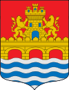
Old bridge of Balmaseda | |||
| |||
 Balmaseda Location of Durango within the Basque Country | |||
| Coordinates: 43°11′45″N 03°11′34″W / 43.19583°N 3.19278°WCoordinates: 43°11′45″N 03°11′34″W / 43.19583°N 3.19278°W | |||
| Country | Spain | ||
| Autonomous community | Basque Country | ||
| Province | Biscay | ||
| Comarca | Enkarterri | ||
| Government | |||
| • Mayor | Joseba Zorrilla Ibáñez (EAJ-PNV) | ||
| Area | |||
| • Total | 22,3 km2 (86 sq mi) | ||
| Elevation | 146 m (479 ft) | ||
| Population (2011) | |||
| • Total | 7,583 | ||
| • Density | 34/km2 (88/sq mi) | ||
| Time zone | CET (UTC+1) | ||
| • Summer (DST) | CEST (UTC+2) | ||
| Postal code | 48800 | ||
| Website |
www | ||


Balmaseda (in Basque and officially, in Spanish: Valmaseda) is a town and municipality located in the province of Biscay, in the Basque Country. Balmaseda is the capital city of the comarca of Enkarterri, in western Biscay and serves an important role in the province thanks to its proximity to the capital city of Bilbao and the regions of Cantabria and Castile and León.
Etymology
Its toponomy probably comes from a union of the Spanish word val (apocope of valle), meaning "valley", and the Basque mahatseta, which means "vineyard", Val-Mahatseta would then mean "valley of vineyards", which would eventually evolve into Valmaseda, currently in use in Spanish, and Balmaseda, following the orthographic rules of the Basque language.
History
The lands in which Balmaseda is located had been inhabited since centuries before its official foundation, with evidence of ancient pastoral activity.[1] In the eastern end of the municipality there is a Roman milestone which belonged to the Pisorica-Flaviobriga road, which connected the present-day cities of Castro Urdiales and Herrera de Pisuerga. This road is believed to have been in use at least since the 1st Century,[1] as the milestone is dated 238. Even though the town's old bridge could have been built simultaneously, there are not any evidences of its existence until some centuries later.[1]
The territory in which today is located Balmaseda belonged to the valley of Mena, which was already included in the Kingdom of Castile in the 9th Century.[1] Although it was eventually conquered by the Kingdom of Navarre, the Castilians recovered it in 1175, moment when the king handed over the territory to Lope Sánchez de Mena, Lord of Bortedo and kin of the Lord of Biscay. Lope Sánchez founded then the village, probably on the same location of a previous settlement, in one of the banks of the river Kadagua, granting the village the fuero of Logroño. Among the reasons for the foundation of the village were its protected location between mountains and the existence of a commercial road connecting to Castile and Biscay.
The village was incorporated to the lands of the Lord of Biscay when the Lord Lope Díaz II de Haro married the daughter of Alfonso IX, thus obtaining the territories of Balmaseda and Orduña.[1] In 1234, Lope confirmed the municipal charter establishing Balmaseda as a town. However, this first union with Biscay would not last much; in 1255 the town was converted back to Castile because of the disputes caused by Diego López III de Haro.[1] In 1274 it was given back to Biscay to be once more handed back to Castile in 1288 after the murder of Lope Díaz III in Alfaro following the orders of Sancho IV. Diego López IV would once more reinstate Balmaseda into Biscay.[1] In 1312, after the disputes between Biscay and Castile, Balmaseda was once more reintegrated into the kingdom. The town would be incorporated again in Biscay in 1388, as it was requested by the village itself.
On 5 November 1808 the city was the theatre of the Battle of Valmaseda, part of the Peninsular War, between French and Spanish armies.
Geography
-Iglesia_de_San_Severino-1.jpg)
_04.jpg)
The municipality of Balmaseda is located in very mountainous territory, in southwestern Biscay and 30 kilometers away from the province capital city Bilbao. Balmaseda is located in the comarca of Enkarterri and it borders Artzentales, in the west, with Sopuerta in the north and Zalla in the east. In the south Balmaseda borders with the autonomous community of Castile and León (province of Burgos). It is surrounded by the Ordunte mountains; Kolitza, Canto, Terreros and La Garbea.
Nature park of Valley of Karrantza with Pozalagua Cave situated not far (and accessible by public buses and taxi) from Balmaseda.
Hydrography
The main river of the municipality is the river Kadagua, which forms the narrow valley where the town is located. The river is joined by several minor streams as the Acebo, Coliza, Tueros and Angostura. The river Kadagua has had historical importance for the town and still today has an important symbolism, as it is present on the town's coat of arms.
Social sphere
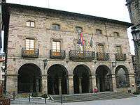
Amongst city's landmarks are Puente Viejo Roman Bridge (XIII), Ayuntmiento-Town Hall, Cathedral Iglesia de San Severino (XIV), Church of Sagrado Corazón (Klaret Antzokia), Iglesia San Juan, Iglesia de Santa Clara with museum, Palacio Horcasitas, Balmaseda historical museum, La Encartada beret factory museum, modern court of justice.
Balmaseda carries Medieval market in March and San Severino festival on 23 October.
Balmaseda has Sociedad Deportiva Balmaseda Fútbol Club (since 1914) with home La Baluga camp stadium.
Transport
Balmaseda is connected with the rest of the province of Enkarterri region and the capital city of Bilbao by the BI-636 road and by the narrow-gauge railway Feve and by bus (Bizkaibus-route number A0651).
Twin towns - Sister cities
See also
- Balmaceda, an alternate spelling found in Spanish surnames.
References
External links
| Wikivoyage has a travel guide for Balmaseda. |
| Wikimedia Commons has media related to Balmaseda. |
- BALMASEDA in the Bernardo Estornés Lasa - Auñamendi Encyclopedia (Euskomedia Fundazioa) (Spanish)