Baltic Shield
The Baltic Shield, sometimes referred to as the Fennoscandian Shield, is located in Fennoscandia (Norway, Sweden and Finland), northwest Russia, northern Denmark and under the Baltic Sea. The Baltic Shield is defined as the exposed Precambrian northwest segment of the East European Craton. It is composed mostly of Archean and Proterozoic gneisses and greenstones which have undergone numerous deformations through tectonic activity (see Geology of Fennoscandia map ). The Baltic Shield contains the oldest rocks of the European continent. The lithospheric thickness is about 200-300 km. During the Pleistocene epoch, great continental ice sheets scoured and depressed the shield's surface, leaving a thin covering of glacial material and innumerable lakes and streams. The Baltic Shield is still rebounding today following the melting of the thick glaciers during the Quaternary Period.
Provinces and blocks
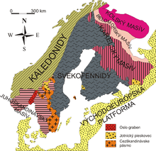
The Baltic Shield is divided into five provinces: the Svecofennian and Sveconorwegian (or Southwestern gneiss) provinces in Fennoscandia, and the Karelian, Belomorian and Kola provinces/cratons in Russia. The latter three are divided further into several blocks and complexes and contain the oldest of the rocks, at 2.5–3.4 Ga (billion years). The Vodlozero block in south-eastern Karelia has been dated to 3.4 Ga. The youngest rocks belong to the Sveconorwegian province, at 900–1700 Ma old. Sometimes included as part of the Baltic Shield is the East European Platform (or Russian Platform), an area of western Russia covered by 3 km of sedimentary rock.
According to the Swedish Museum of Natural History (2006), the oldest rocks of the Fennoscandian Shield are found in the northeast, in the Kola peninsula, Karelia and northeastern Finland. These Archean rocks are mainly gneisses and greenstone belts, ca. 2.5-3.1 Ga. Within this area, there are also some Paleoproterozoic cover rocks (Karelian rocks), ca. 1.9-2.5 Ga, and the ca. 1.9 Ga collisional Lapland granulite belt. Some Archean rocks are also found in northernmost Sweden (Norrbotten County), and Archean crust probably underlies much of that area.
Most of northern and central Sweden, however, belongs to the Svecofennian province, together with the southwestern part of Finland. The bedrock here formed 1.75-1.9 Ga during the Svecofennian (also known as Svecokarelian) orogeny. This bedrock includes both metasedimentary and metavolcanic rocks and several generations of granitoids, and hosts the Bergslagen ore deposits (iron and sulfide ores), the Skellefte (sulfides) and Norrbotten (iron and sulfide ores) districts. This area also contains some younger (ca. 1.5-1.65 Ga) Rapakivi granites as well as Jotnian sandstones (ca. 1.2-1.5 Ga).
The Transscandinavian Igneous Belt (TIB) consists of largely undeformed granitoids and associated porphyries formed in at least three different episodes between c. 1800 and 1650 Ma ago. It stretches from Småland in southern Sweden through Värmland and western Dalarna (where it is partly covered by Jotnian sandstone) and then continues under much of the Caledonian mountain chain up to northern Scandinavia. Southwest the TIB follows the Southwestern gneiss province (also known as the Sveconorwegian province), which has a long and complex evolution ranging from ca. 1.7 to 0.9 Ga ago. Most of the bedrock originally formed in the Gothian orogeny 1.7-1.55 Ga, but was later intruded by several generations of granitoids, the youngest in Sweden being the 900 Ma old Bohus granite, and metamorphosed and deformed again during the Sveconorwegian orogeny ca. 1.1-0.9 Ga.
The Southwestern gneiss province is divided into several north-south-trending segments by Sveconorwegian deformation zones. In western Norway, these gneisses were again deformed during the Caledonian orogeny ca. 400 Ma. The Scandinavian Caledonides, which stretch through most of Norway and include adjacent parts of Sweden, are made up of Neoproterozoic to Silurian metasedimentary and metavolcanic rocks, deposited in the Iapetus Ocean (the predecessor of the present-day Atlantic Ocean) c. 700 to 400 Ma ago. Together with slices of older basement, these rocks were thrust several 100 km eastwards over the edge of the Fennoscandian Shield in several large thrust sheets known as nappes, when North America and Greenland collided with Scandinavia during the Caledonian orogeny ca. 400 Ma ago. Areas of Caledonian deformation, which also include the Precambrian gneisses of western Norway.
Remains of Cambro-Silurian sedimentary cover (550-400 Ma old sandstones, shales and limestones) are found in some areas in southern Sweden, while Mesozoic and Tertiary sediments (younger than 250 Ma) are found in southernmost Sweden (Skåne) and in Denmark. Similar Phanerozoic rocks also cover the Baltic republics, Poland and northern Germany. The magmatic rocks of the Permian (c. 250 Ma) Oslo Graben formed in a failed rift system that continues into the Skagerrak and the North Sea.
Regolith
Thought to be formerly part of an ancient continent, the Baltic Shield grew in size through collisions with neighbouring crustal fragments. The mountains created by these tectonic processes have since been eroded to their bases, the region being largely flat today. Through five successive Pleistocene glaciations and subsequent retreats, the Baltic Shield has been scoured clean of its overlying sediments, leaving expansive areas (most within Scandinavia) exposed. It is therefore of importance to geophysicists studying the geologic history and dynamics of eastern Europe.
The scouring and compression of the Baltic Shield by glacial movements created the area's many lakes and streams, the land retaining only a thin layer of sandy sediment collected in depressions and eskers. Most soil consists of moraine, a grayish yellow mixture of sand and rocks, with a thin layer of humus on top. Vast forests, featuring almost exclusively the three species pine, spruce and birch, dominate the landscape, clearly demarcating its boundaries. The soil is acidic and has next to no carbonates such as limestone. The scouring by the ancient glaciers and the acidity of the soil have destroyed all palaeontologically interesting materials, such as fossils.
Belomorian and Karelian provinces
The Archean segment of the Baltic/Fennoscandian shield is divided into the Karelian, Belomorian and Kola provinces. The Karelian province is a granite-greenstone province reworked during the Proterozoic. The North Karelian greenstone belt sequence (NKGBS) is dominated by volcanics of calc-alkaline series, diorite-plagiogranitic batholith, and xenoliths of ultramafic to andesite-dacite composition.
According to a study by Slabunov (1999): "The Belomorian Province is a mobile belt that evolved in a polycyclic manner. A lateral sequence of Late Archean tectonic units has been revealed in the Belomorian Province and in the eastern part of the Karelian Province. The collision events in the Belomorian Province are represented by high pressure (6–12 kbar) and high temperature (500–700°C) kyanite-facies metamorphism, granitoid magmatism, and the formation of folded nappe structure and granite gneiss domes. The time of collision is estimated at 2.7–2.74 Ga. This stage of evolution in the NE part of Karelian Province is accompanied by the generation of North Karelian greenstone belt (NKGB).
The Belomorian Belt is a tectonic pile of metasedimentary, metavolcanic and metaplutonic rocks which has been folded and metamorphosed several times. According to a study by Bibikova et al. (1999), the earliest metamorphic event took place ca. 2.8 Ga. "Sm-Nd isotope studies of whole rock metasediment samples have constrained their mean protolith ages to between 3.00 and 2.86 Ga, indicating a short prehistory....Zircons were separated from different localities and at various levels of the Belomorian tectonostratigraphical column. We have recognized three age groups of ancient cores at 3.2–3.1 Ga, 3.00–2.97 Ga and 2.93–2.90 Ga. The plus 3.1 Ga cores were obtained solely from localities in the northern part of the Belt. It has also been possible to distinguish three groups of metamorphic grains and overgrowths which are 2.84–2.80 Ga, 2.72–2.68 Ga and ca. 2.61 Ga old. The data presented confirm the absence of detrital material older than 3.2 Ga in the Belomorian metasediments. This differs from the adjacent Karelian craton where crustal rocks of about 3.4 Ga have been recorded. If these ages are representative of the rocks discussed, our data suggest that the Belomorian Belt represents a Neoarchaean accretionary environment in the vicinity of the Karelian craton." (Bibikova et al., 1999).
From NE to SW the Baltic shield consists of the following structural-formational zones: 1) the Central Belomorian mafic zone (CBMZ) dominantly formed by mafic and ultramafic rocks, 2) the Chupa Paragneissic Belt (ChPB) composed of deep and repeatedly metamorphosed metagraywackes (mainly high-alumina gneisses), 3) the North Karelian system of greenstone belts (NKGB) dominated by volcanics of calc-alkaline series, and 4) the North Karelian diorite-plagiogranitic batholith (NKB) and xenoliths of ultramafic to andesite-dacite composition that occur in it. The CBMZ is dominated by metabasalts (amphibolites) with widespread metaultrabasic rocks (metaperidotites, serpentinites and apoultramafic amphibolites), and extremely rare acid metavolcanics. The chemical composition of metabasalts in the CBMZ is similar to that of mid-oceanic ridge basalts (MORB). The isotopic age of the rhyolite-dacites is 2.887 Ga. This association is interpreted as a fragment of a Late Archean ophiolitic complex. The CBMZ marks a collision suture. The supracrustal strata of NKGBS consist of metabasalts, metakomatiites and felsic to intermediate metavolcanics. Metaandesites-metarhyolites make up a considerable portion of the sequence. The age of these volcanics is estimated at 2.877–2.820 Ga. Between the NKGB and the CBMZ there lies the ChPB which consists of metagraywackes (garnet-biotite kyanite-bearing gneisses. This lateral series indicates the Late Archean (3.0–2.8 Ga) subduction stages in the evolution of the eastern Baltic shield. During the first stage, the oceanic lithosphere subducted from NE to SW under the subcontinental crust. In the second stage it subducted under the continental crust of the Karelian plate." (Slabunov, 1999)
Kola province
The Archaean Kolmozero-Voronja greenstone belt is located on the Kola Peninsula between Murmansk, Central Kola and the Keivy terrains of Upper Archaean age. Four suites are distinguished in the greenstone belt:
Ljavozerskya (lower terrigenous formation), Polmostundrovskya (komatiite-tholeiite), Voronjatundrovskya (basalt-andesite-dacite) and Chervurtskya (an upper terrigenous formation). Zircon in the quartz of the upper part of the Voronjatundrovskya suite yield an U-Pb age of 2.8 Ga. This is interpreted as the intrusive emplacement of the quartz porphyry during the final stage of the belt development. Ovoid plagioamphibolites are present among schistose plagioamphibolites of the Polmostundrovsky suite and have been dated at ~2.6 Ga, indicative of andalusite-sillimanite facies metamorphism. Tourmaline granites are found all over the Kolmozero-Voronja belt occurring among volcanogenic sedimentary rocks with good correlation dating of 2520±70 Ma. (Kudryashov, 1999).
The geochronological data document a long and complicated evolution of the belt:
- 3.0–2.9 Ga formation of a mafic volcanic sequence and its probable magmatic analogue, a ~2.9 Ga old gabbro,
- 2.9–2.8 Ga formation of intermediate and felsic volcanic rocks with an upper age limit of ~2.83 Ga,
- 2.7–2.6 Ga granodiorite intrusions and their vein analogues,
- and 2.6–2.5 Ga intrusion of postkinematic tourmaline and microcline granites. (Kudryashov, 2001).
Within the Murmansk block, from west to east, there is an increase in the rare earth elements (REE) content in the initial melts, a change in composition of protoliths from tholeiite with the highest content of REE to subalkaline basalt, and in the eastern part of the Murmansk block the REE content is even higher. The origin of tonalites and trondhjemites (TT) is most likely the result of partial melting of mafic sources. The increase of alkalinity in the protoliths of TT-gneisses correlates with the abundance of the Late Archean peralkaline (2750±50 Ma) and alkaline (2760±60 Ma) granite massifs here. (Turkina and Vetrin, 1999).
Northeastern Baltic Shield
The Keivy complex in the NE Baltic shield consists mainly of sheet-like peralkaline granite bodies, granosyenite dykes and some nepheline syenite fault-type intrusions in the total exposed ~2500 km. square area.
According to a study by Bayanova and Zozulya (1999), the emplacement ages for peralkaline granite magmatic vary from 2610 Ma for the White Tundra massif to 2670 Ma for the Western Keivy massif and are spatially confined to voluminious gabbro-anorthosite magmatism of 2.66–2.68 Ga. The predominantly "juvenile" Sm-Nd isotopic signatures from most suites of Keivy complex suggest that they must be of mantle derivation or else have has short-lived crustal precursors. "The granites are petrologically and geochemically similar to Phanerozoic A-type granitoids, presumably emplaced into noncompressive or extensional environments. The distinct tectonic regime of such type of granites indicates that the Keivy peralkaline granite magmatism can be regarded as a consequence of post-collisional events. Collision in the region has possibly taken place earlier than 2.74 Ga. The granites studied were formed after the Late Archaean Keivy-Voronja greenstone belt evolution." (Bayanova, 1999). The above model suggests that the NE Archaean portion of the Baltic shield was dominated by plume tectonics.
The Laplandian Granulite Belt is in the central northeast section of the Baltic shield. Garnet plagiogranitoids occur in the northeastern part, crystallised from melting of host rock acid granulites. The absence of stratification in the north part of the Lapland Granulite Belt are related to the E-W extension at the final period of thrusting. This deformation stage was characterised by persistently high temperatures and increasing water activity. (Kozlov and Kozlova, 1999).
Southeastern Baltic Shield
The Sumozero-Kenozero greenstone belt in the southeastern section of the Baltic shield is ~400 km long and up to 50 km wide. It comprises a 5-km thick oceanic plateau sequence of submarine komatiite-basalt lava and volcanic sediments. The belt is intruded and overlain by an island arc-like sequence of intermediate-felsic volcanic rocks including andesitic basalts, andesites, dacites and rhyolites. According to a study by Puchtel et al. (1999): "The komatiites were derived from a liquid containing ~30% MgO. This liquid was initiated at depths of 300–400 km in a mantle plume that was some 250°C hotter than the ambient mantle. Both komatiites and basalts of the lower sequence are strongly depleted in LREE, have high εNd(T) of +2.7±0.3, relatively unradiogenic Pb isotope compositions (µ m1 = 8.7±0.2) and show Nb-maxima (Nb/Nb* = 1.2±0.2, Nb/U = 43±6)." These parameters are found in a number of other early Precambrian greenstones and in recent Pacific OFB. "They are regarded as plume source characteristics and provide further evidence for the existence of certain Nb-excess in the Archaean mantle due to the early extraction of large volumes of continental crust with low Nb/U ratios. The intermediate-felsic volcanic and subvolcanic rocks of the upper unit are enriched in LREE, depleted in HFSE, but have positive εNd(T) values of +2.5±1.2. They represent both mantle wedge-derived basalt-andesite-dacite-rhyolite (BADR), and slab-derived (adakite) melts, erupted in the inner and frontal parts of an intraoceanic island arc." U-Pb zircon ages for the felsic volcanic rocks are 2875±2 Ma, and Pb-Pb and Sm-Nd ages of 2892±130 and 2916±117 Ma for the komatiites-basalts.
Vodla Block
The Sumozero-Kenozero greenstone belt displays fragments of unsubductable oceanic crust, represented by the lower mafic-ultramafic volcanic sequence, and also displays the products of subduction-related magmatism. This implies that the thick plume-derived oceanic crust reached an intraoceanic convergent plate boundary and was intruded and overlain by felsic melts coming from both a subducting slab and an overlying mantle wedge. Later, the oceanic plateau, together with the volcanic arc complex built on top of it, were accreted to and obducted onto the continental crust of the Vodla block. (Hofmann et al., 1999)
Economic geology
The Baltic Shield yields important industrial minerals and ores, such as those of iron, nickel, copper and platinum group metals. Because of its similarity to the Canadian Shield and cratons of southern Africa and Western Australia, the Baltic Shield had long been a suspected source of diamonds and gold. Currently, especially the Central Lapland Greenstone Belt in the north is considered to be an unexplored area that has the potential to hold exploitable gold deposits.
Recent exploration by De Beers and others has revealed a significant number of diamond-bearing kimberlites in the Kola Peninsula, and (possibly extensive) deposits of gold in Finland. In Sweden, Alcaston Diamond NL is presently conducting a diamond exploration project, claiming some 9,550 km².
Baltic Shield relation to Baltic plate
There is considerable misunderstanding in the literature with the use of the term "Baltic Shield." A shield in any craton is the area of exposed crystalline crust while the other part of a craton is a “platform” where the crystalline crust or basement is overlaid by younger sedimentary cover. Thus the crustal segments comprise both the shield areas and parts of the platform basement. As such, the Baltic Shield is not the same as the Baltic Plate. The Baltic, Ukrainian shields and the Voronezh Massif are the present-day geomorphological highs which were formed much later, even in the Cenozoic. Geomorphologically the Baltic Shield is only one segment/region of the East European craton. The East European craton as a whole was a part of Neoproterozoic-Early Palaeozoic Baltica.
References
- Bayanova, Tamara, and Dmitry Zozulya (1999) "Discrimination Between Plume and Plate Tectonics in Late Archaean of NE Baltic Shield from the Study of the Keivy A-Granite Complex." Journal of Conference Abstracts, Vol. 4, No. 1, Symposium A08, Early Evolution of the Continental Crust.
- Bibikova, Elena V., Svetlana Bogdanova, Stefan Claesson and Torbjorn Skiold. (1999) "NORDSIM Ages on Provenance and Metamorphic Zircon Material in Belomorian Metasediments of the Baltic Shield." Journal of Conference Abstracts, Vol. 4, No. 1, Symposium A08, Early Evolution of the Continental Crust.
- Evans, Paul. 1999. Precambrian evolution of the major Archaean blocks of the Baltic Shield. University of Oulu, Dept. of Geology, Finland.
- Kozlov, Nikolai Ye, and Natalia Ye Kozlova. (1999) "Relation between Garnet Plagiogranitoids and Acid Granulites in Laplandian Granulite Belt." Journal of Conference Abstracts, Vol. 4, No. 1, Symposium A08, Early Evolution of the Continental Crust.
- Kudryashov, Nikolay. (1999) "Archean Kolmozero-Voronja Greenstone Belt: U-Pb Zircon and Sphene Data." Journal of Conference Abstracts, Vol. 4, No. 1, Symposium A08, Early Evolution of the Continental Crust.
- Kudryashov, Nikolay. (2001) "On Archean Evolution of the Kolmozero-Voronja Greenstone Belt (Kola Peninsula, Russia) U-Pb and Pb-Pb Dating." EUG XI Symposium LS07, Origin and Significance of Major Boundaries in the Deep crust and Continental Lithosphere. Online Abstract:
- Puchtel, Igor, Albrecht Hofmann, Alexander Samsonov, and Andrey Shchipansky. (1999) "Combined Hotspot-Island Arc Model for the Formation of the 2.9 Ga Sumozero-Kenozero Greenstone Belt, SE Baltic Shield." Journal of Conference Abstracts, Vol. 4, No. 1, Symposium A08, Early Evolution of the Continental Crust.
- Slabunov, Alexander. (1999) "Late Archaean Subduction and Collision Events in the Crustal Evolution of the Eastern Fennoscandian/Baltic Shield." Journal of Conference Abstracts, Vol. 4, No. 1, Symposium A08, Early Evolution of the Continental Crust.
- Swedish Museum of Natural History. (2006) "Geology of Fennoscandia."
- Turkina, Olga M. and Valeri R. Vetrin. (1999) "Composition of Tonalite - Trondhjemite Protoliths from the Kola Superdeep Borehole (KSDB) and on the Surface." Journal of Conference Abstracts, Vol. 4, No. 1, Symposium A08, Early Evolution of the Continental Crust.
External links
- Rb-Sr Data for Diamond-Bearing Kimberlite and Alkaline Massives in NE Fennoscandia
- Precambrian evolution of the major Archaean blocks of the Baltic Shield (archive.org link)
- Geology of Fennoscandia - from Swedish Museum of Natural History - retrieved 2010-07-05.
- Why does the East European Platform has (sic) 3 km of sediments? Insights from lithospheric structure, thermal regime, and composition (PDF file)