Balwest
| Balwest | |
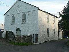 Balwest Methodist chapel, a Grade II listed building |
|
 Balwest |
|
| OS grid reference | SW594298 |
|---|---|
| Shire county | Cornwall |
| Region | South West |
| Country | England |
| Sovereign state | United Kingdom |
| Postcode district | TR13 |
| Police | Devon and Cornwall |
| Fire | Cornwall |
| Ambulance | South Western |
| EU Parliament | South West England |
| UK Parliament | St Ives (UK Parliament constituency) |
Coordinates: 50°07′15″N 5°21′56″W / 50.12082°N 5.36551°W
Balwest (Cornish: Bal West, meaning Western mine) is a hamlet in the civil parish of Germoe[1] in west Cornwall, England, in the United Kingdom .[2]
The hamlet is on the southern edge of a former mining area, part of a geological formation known as the Tregonning-Godolphin Granite (one of five granite batholiths in Cornwall) which was formerly an important source of tin and copper ore (see also Geology of Cornwall).
A Wesleyan Methodist chapel was opened at Balwest in 1829 for miners.[3] The building is Grade II listed.
References
- ↑ "Archived copy". Archived from the original on May 5, 2010. Retrieved May 1, 2010. Cornwall Council online mapping. Retrieved May 2010
- ↑ Ordnance Survey: Landranger map sheet 203 Land's End ISBN 978-0-319-23148-7
- ↑ GENUKI website: Germoe. Retrieved May 2010
Cornwall Portal | |
| Unitary authorities | |
| Major settlements |
|
| Rivers | |
| Topics | |
This article is issued from Wikipedia - version of the 7/20/2016. The text is available under the Creative Commons Attribution/Share Alike but additional terms may apply for the media files.