Bara-lacha la
| Bara-lacha la | |
|---|---|
|
Bara-lacha la | |
| Elevation | 4,890 m (16,043 ft) |
| Traversed by | Leh–Manali Highway |
| Location | India |
| Range | Himalaya |
| Coordinates | 32°44′N 77°26′E / 32.733°N 77.433°ECoordinates: 32°44′N 77°26′E / 32.733°N 77.433°E |
 | |


Bara-lacha la also known as Bara-lacha Pass, or Bārā Lācha La,[1] (el. 4,890 m or 16,040 ft)[2][3] is a high mountain pass in Zanskar range,[4] connecting Lahaul district in Himachal Pradesh to Ladakh in Jammu and Kashmir, situated along the Leh–Manali Highway.

The Bhaga river, a tributary of the Chandrabhaga or Chenab river, originates from Surya taal lake, which is situated a few of kilometers from the pass towards Manali. The other major tributary of the Chandrabhaga, the Chandra also originates from glacier in this region.[4] The pass also acts as a water-divide between the Bhaga river and the Yunam river.[5]
Legend
Folklore states that there were two lovers, Chandra being the daughter of the Moon and Bhaga the son of the Sun god. To perform their eternal marriage, they decided to climb to the Bara-lacha-la and from there they ran in opposite directions. Chandra being active and smart, easily found her way and reached Tandi after covering the distance of 115 km (71 mi). Soon Bhaga was found coming with great struggle through the narrow gorges to Tandi, where consequently both met and the celestial marriage was performed. Bhaga covered about 60 km (37 mi) distance, which was very difficult.[6]
Baralachala means summit with cross roads from Spiti, Ladakh, Zanskar and Lahaul meet here and in ancient times it was part of a trade route. On the North West lies the Bhaga River while the Chandra flows south-east. Near below the Baralacha-la is having a beautiful emerald lake the Suraj tal (Sun lake), the source of the river Bhaga.
Miscellaneous
In Rudyard Kipling's novel Kim, there is a reference to Bara-lacha la pass the source of the Suraj Tal having been used by Kim's Lama to enter India from Tibet.[7]
A trekking route leads from Bara-lacha la to Chandra Taal, situated by the bank of Chandra River in the Spiti Valley. In about a week's time, trekking in this region involves camping and walking at reasonably high altitude, and crossing a few glacial rivers. The basic day wise itinerary that trekkers can follow is:[8]
- Manali (2000 m) - Batal (3907 m) drive
- Batal (3907 m) - Chandrataal (4300 m) hike
- Chandrataal (4300 m) - Tokpo Gongma (4320 m) hike
- Tokpo Gongma (4320 m) - Tokpo Yongma (4640 m) hike
- Tokpo Yongma (4640 m) - Baralacha La (4900 m) - Manali
References
- ↑ Geonames.org. "Bārā Lācha La". Retrieved 2009-08-06.
- ↑
- ↑
- 1 2 Gosal, G.S. (2004). "Physical Geography of the Punjab" (PDF). Journal of Punjab Studies. Center for Sikh and Punjab Studies, University of California. 11 (1): 31. ISSN 0971-5223. Retrieved 2009-08-06.
- ↑ R. K. Pant; N. R. Phadtare; L. S. Chamyal & Navin Juyal (June 2005). "Quaternary deposits in Ladakh and Karakoram Himalaya: A treasure trove of the palaeoclimate records" (PDF). Current Science. 88 (11): 1789–1798. Retrieved 2009-08-06.
- ↑ Lahaul & Spiti
- ↑ Manali - Leh Jeep Safari-II
- ↑ "Chandratal to Baralacha La Trek - AlienAdv.com".
Gallery
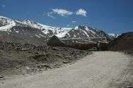
-
View of Bara-lacha la in June
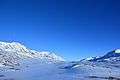
-
Bright Sunny day at Bara-lacha la
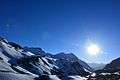
-

Bara-lacha la snow-covered mountain
External links
| Wikimedia Commons has media related to Bara-lacha La. |
- Lahaul and Spiti - Baralacha Pass
- Bara-lacha-la photos on Trek Earth
- More Bara-lacha-la photos on Trek Earth
- Moon lake trek - Over baralacha la
- Batal Bara-lacha-la road and trekking map