Barkley Regional Airport
| Barkley Regional Airport | |||||||||||||||
|---|---|---|---|---|---|---|---|---|---|---|---|---|---|---|---|
|
| |||||||||||||||
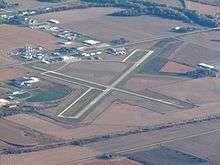 Aerial view, October 2011 | |||||||||||||||
| IATA: PAH – ICAO: KPAH – FAA LID: PAH | |||||||||||||||
| Summary | |||||||||||||||
| Airport type | Public | ||||||||||||||
| Owner | Barkley Regional Airport Authority | ||||||||||||||
| Serves | Paducah, Kentucky | ||||||||||||||
| Elevation AMSL | 410 ft / 125 m | ||||||||||||||
| Coordinates | 37°03′37″N 088°46′23″W / 37.06028°N 88.77306°WCoordinates: 37°03′37″N 088°46′23″W / 37.06028°N 88.77306°W | ||||||||||||||
| Website | BarkleyRegional.com | ||||||||||||||
| Map | |||||||||||||||
 PAH Location in Kentucky | |||||||||||||||
| Runways | |||||||||||||||
| |||||||||||||||
| Statistics (2013) | |||||||||||||||
| |||||||||||||||
Barkley Regional Airport (IATA: PAH[2], ICAO: KPAH, FAA LID: PAH) is 14 miles west of Paducah, in McCracken County, Kentucky. The airport is owned by the Barkley Regional Airport Authority.[1] It is used for general aviation and sees one airline subsidized by the Essential Air Service program.
100 people are employed at the airport. The only airline is United Express operated by SkyWest Airlines, two daily Canadair Regional Jets to Chicago. Barkley Regional Airport is the 5th busiest in Kentucky.
The National Plan of Integrated Airport Systems for 2011–2015 categorized it as a primary commercial service airport.[3] Federal Aviation Administration records say this airport had 21,654 passenger boardings (enplanements) in calendar year 2008,[4] 18,542 in 2009, and 19,903 in 2010.[5]
History
Barkley Regional Airport is named after former Vice-President of the United States, Alben W. Barkley, who was from Western Kentucky. The airport was previously served by Northwest Airlink operated by Mesaba Airlines, with Saab turboprops to Memphis International Airport. When Northwest merged with Delta Air Lines, service to Memphis from Paducah ended. This service was quickly replaced when the Chicago-based United Airlines started operating daily CRJ-200s to Chicago-O'Hare International Airport. The service is operated by SkyWest Airlines for United Express. Service began in the Winter of 2010.
Facilities
Barkley Regional Airport covers 1,018 acres (412 ha) at an elevation of 410 feet (125 m). It has two asphalt runways: 4/22 is 6,499 by 150 feet (1,981 x 46 m) and 14/32 is 5,500 by 150 feet (1,676 x 46 m).[1] An expansion of runway 14/32 was completed in December 2005.
In the year ending December 31, 2013, the airport had 28,288 aircraft operations, average 77 per day: 82% general aviation, 5% airline, 8% air taxi, and 5% military. 44 aircraft were then based at this airport: 73% single-engine, 16% multi-engine, and 11% jet.[1]
Airline and destination
Scheduled passenger service:
| Airlines | Destinations |
|---|---|
| United Express | Chicago-O'Hare |
Statistics
| Carrier | Passengers (arriving and departing) |
|---|---|
| SkyWest | 42,670(100%) |
| Rank | Airport | Passengers | Airline |
|---|---|---|---|
| 1 | O'Hare International (ORD) | 21,000 | United Express |
References
- 1 2 3 4 FAA Airport Master Record for PAH (Form 5010 PDF). Federal Aviation Administration. Effective April 5, 2012.
- ↑ "IATA Airport Code Search (PAH: Barkley Regional)". International Air Transport Association. Retrieved July 11, 2013.
- ↑ "2011–2015 NPIAS Report, Appendix A" (PDF). National Plan of Integrated Airport Systems. Federal Aviation Administration. October 4, 2010. Archived from the original (PDF, 2.03 MB) on September 27, 2012.
- ↑ "Enplanements for CY 2008" (PDF, 1.0 MB). CY 2008 Passenger Boarding and All-Cargo Data. Federal Aviation Administration. December 18, 2009.
- ↑ "Enplanements for CY 2010" (PDF, 189 KB). CY 2010 Passenger Boarding and All-Cargo Data. Federal Aviation Administration. October 4, 2011.
- 1 2 "Paducah, KY: Barkley Regional (PAH)". Bureau of Transportation Statistics (BTS), Research and Innovative Technology Administration (RITA), U.S. Department of Transportation. September 2014. Retrieved March 2016. Check date values in:
|access-date=(help)
Other sources
- Essential Air Service documents (Docket DOT-OST-2009-0160) from the U.S. Department of Transportation:
- Ninety-day notice (July 15, 2009): from Mesaba Aviation, Inc. of its intent to discontinue unsubsidized scheduled air service at the following communities, effective October 12, 2009: Paducah, KY; Alpena, MI; Muskegon, MI; Hancock, MI; Sault Ste. Marie, MI; International Falls, MN; Tupelo, MS and Eau Claire, WI.
- Essential Air Service documents (Docket OST-2009-0299) from the U.S. Department of Transportation:
- Memorandum (November 19, 2009): closing out docket DOT-2009-0160 and opening up eight new dockets for the various communities (Alpena, MI; Eau Claire, WI; Hancock/Houghton, MI; International Falls, MN; Muskegon, MI; Paducah, KY; Sault Ste. Marie, MI; Tupelo, MS).
- Order 2009-10-8 (October 16, 2009): selecting SkyWest Airlines, Inc., d/b/a United Express, to provide subsidized essential air service (EAS) at Hancock/Houghton and Muskegon, Michigan, Paducah, Kentucky, and Eau Claire, Wisconsin.
- Order 2012-1-24 (January 26, 2012): tentatively re-selecting SkyWest Airlines, Inc. to provide Essential Air Service (EAS) with subsidy rates as follows: Eau Claire, Wisconsin, $1,733,576; Hancock/Houghton, Michigan, $934,156; Muskegon, Michigan, $1,576,067; and Paducah, Kentucky, $1,710,775.
- Order 2012-2-2 (February 1, 2012): makes final the selection of SkyWest Airlines, Inc., to provide Essential Air Service at Eau Claire, Wisconsin; Hancock/Houghton, Michigan; and Paducah, Kentucky (at Muskegon, the selection of SkyWest was not finalized at this time).
- Order 2013-10-8 (October 21, 2013): reselecting Delta Air Lines, Inc., to provide Essential Air Service (EAS) at Pellston and Sault Ste. Marie, Michigan; and SkyWest Airlines, at Paducah, Kentucky; Hancock/Houghton, and Muskegon, Michigan; and Eau Claire, Wisconsin. The Order also tentatively reselects American Airlines, at Watertown, New York. Paducah, Kentucky: Docket 2009-0299; Effective Period: January 1, 2014, through January 31, 2016; Service: Fourteen (14) nonstop round trips per week to Chicago O'Hare (ORD); Aircraft Type: CRJ-200; Annual Subsidy: $2,034,160.
External links
- Barkley Regional Airport, official site
- NWS Paducah Kentucky
- Aerial image as of November 1998 from USGS The National Map
- FAA Airport Diagram (PDF), effective November 10, 2016
- FAA Terminal Procedures for PAH, effective November 10, 2016
- Resources for this airport:
- AirNav airport information for KPAH
- ASN accident history for PAH
- FlightAware airport information and live flight tracker
- NOAA/NWS latest weather observations
- SkyVector aeronautical chart for KPAH
- FAA current PAH delay information