McCracken County, Kentucky
| McCracken County, Kentucky | |
|---|---|
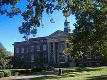 McCracken County courthouse in Paducah | |
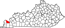 Location in the U.S. state of Kentucky | |
 Kentucky's location in the U.S. | |
| Founded | 1825 |
| Named for | Virgil McCracken |
| Seat | Paducah |
| Largest city | Paducah |
| Area | |
| • Total | 268 sq mi (694 km2) |
| • Land | 249 sq mi (645 km2) |
| • Water | 19 sq mi (49 km2), 7.2% |
| Population | |
| • (2010) | 65,565 |
| • Density | 264/sq mi (102/km²) |
| Congressional district | 1st |
| Time zone | Central: UTC-6/-5 |
| Website |
mccrackencounty |
McCracken County is a county located in the U.S. state of Kentucky. As of the 2010 census, the population was 65,565.[1] The county seat and only municipality is Paducah.[2] McCracken County was the 78th county formed, having been created in 1825.[3]
McCracken County is part of the Paducah, KY-IL Micropolitan Statistical Area. It is part of the Jackson Purchase, located at the extreme western end of Kentucky.
History
McCracken County was founded in 1825, from Hickman County and was named for Captain Virgil McCracken of Woodford County, Kentucky, who was killed in the Battle of Frenchtown in southeastern Michigan during the War of 1812.[4][5]
The Battle of Paducah occurred in McCracken County on March 25, 1864. The skirmish between the Union and Confederate troops ended in a Confederate victory. Altogether 140 men fell in the battle.
Law and government
(Federal)
McCracken County is represented federally as District 1 from the Commonwealth of Kentucky.
(State)
In the Kentucky General Assembly by the entirety of District 3 representing Paducah; a portion of District 2 representing the south of the county and Graves County; most of the county outside of Paducah by District 1 which stretches down the Mississippi River counties of Ballard, Carlisle, Hickman and Fulton; lastly, a tiny sliver of the east of McCracken County near Reidland is represented by the 6th District (Centered on Marshall & Lyon counties).
In the State Senate all of McCracken County is currently represented by the 2nd District and it's State Senator Danny Carroll (R).
Geography
According to the U.S. Census Bureau, the county has a total area of 268 square miles (690 km2), of which 249 square miles (640 km2) is land and 19 square miles (49 km2) (7.2%) is water.[6] The county's northern border with Illinois is formed by the Ohio River, and its northeastern border by the Tennessee River.
Adjacent counties
- Massac County, Illinois (north)
- Livingston County (northeast)
- Marshall County (east)
- Graves County (south)
- Carlisle County (southwest)
- Ballard County (west)
National protected area
Demographics
| Historical population | |||
|---|---|---|---|
| Census | Pop. | %± | |
| 1830 | 1,297 | — | |
| 1840 | 4,745 | 265.8% | |
| 1850 | 6,067 | 27.9% | |
| 1860 | 10,360 | 70.8% | |
| 1870 | 13,988 | 35.0% | |
| 1880 | 16,262 | 16.3% | |
| 1890 | 21,051 | 29.4% | |
| 1900 | 28,733 | 36.5% | |
| 1910 | 35,064 | 22.0% | |
| 1920 | 37,246 | 6.2% | |
| 1930 | 46,271 | 24.2% | |
| 1940 | 48,534 | 4.9% | |
| 1950 | 49,137 | 1.2% | |
| 1960 | 57,306 | 16.6% | |
| 1970 | 58,281 | 1.7% | |
| 1980 | 61,310 | 5.2% | |
| 1990 | 62,879 | 2.6% | |
| 2000 | 65,514 | 4.2% | |
| 2010 | 65,565 | 0.1% | |
| Est. 2015 | 65,018 | [7] | −0.8% |
| U.S. Decennial Census[8] 1790-1960[9] 1900-1990[10] 1990-2000[11] 2010-2013[1] | |||
As of the census[12] of 2000, there were 65,514 people, 27,736 households, and 18,444 families residing in the county. The population density was 261 per square mile (101/km2). There were 30,361 housing units at an average density of 121 per square mile (47/km2). The racial makeup of the county was 86.76% White, 10.88% Black or African American, 0.22% Native American, 0.51% Asian, 0.05% Pacific Islander, 0.40% from other races, and 1.18% from two or more races. Hispanic or Latino of any race were 1.06% of the population.
There were 27,736 households out of which 29.60% had children under the age of 18 living with them, 51.10% were married couples living together, 12.20% had a female householder with no husband present, and 33.50% were non-families. 29.70% of all households were made up of individuals and 12.30% had someone living alone who was 65 years of age or older. The average household size was 2.31 and the average family size was 2.86.
In the county the population was spread out with 23.40% under the age of 18, 7.90% from 18 to 24, 28.10% from 25 to 44, 24.70% from 45 to 64, and 15.90% who were 65 years of age or older. The median age was 39 years. For every 100 females there were 90.50 males. For every 100 females age 18 and over, there were 86.30 males.
The median income for a household in the county was $33,865, and the median income for a family was $42,513. Males had a median income of $36,417 versus $22,704 for females. The per capita income for the county was $19,533. About 11.40% of families and 15.10% of the population were below the poverty line, including 21.90% of those under age 18 and 12.30% of those age 65 or over.
Education
Public elementary and secondary education in the county is provided by two school districts:
- McCracken County Public Schools, which serves the entire county except for the bulk of the city of Paducah, served by:
- Paducah Public Schools
Several private schools also provide K-12 education. These institutions include the St. Mary System and Community Christian Academy.
Higher education is provided by West Kentucky Community and Technical College in Paducah, part of the Kentucky Community and Technical College System. Like all other schools in this system, WKCTC offers associate degrees. The state's largest public university, the University of Kentucky, operates a branch campus of its College of Engineering at WKCTC. Murray State University offers bachelor's degree programs and master's degrees. A new 43,000 square foot facility located on a 23-acre campus adjacent to WKCTC was opened in 2014. In addition, Lindsey Wilson College offers a human services degree at WKCTC and McKendree University operates a Bachelor of Science in Nursing degree program.
Communities
City
- Paducah (county seat)
Census-designated places
Unincorporated communities
See also
References
- 1 2 "State & County QuickFacts". United States Census Bureau. Retrieved March 6, 2014.
- ↑ "Find a County". National Association of Counties. Archived from the original on May 31, 2011. Retrieved 2011-06-07.
- ↑ Collins, Lewis (1877). History of Kentucky. p. 593.
- ↑ http://www.kyenc.org/entry/m/McCRA02.html
- ↑ The Register of the Kentucky State Historical Society, Volume 1. Kentucky State Historical Society. 1903. p. 36.
- ↑ "2010 Census Gazetteer Files". United States Census Bureau. August 22, 2012. Retrieved August 17, 2014.
- ↑ "County Totals Dataset: Population, Population Change and Estimated Components of Population Change: April 1, 2010 to July 1, 2015". Retrieved July 2, 2016.
- ↑ "U.S. Decennial Census". United States Census Bureau. Archived from the original on May 11, 2015. Retrieved August 17, 2014.
- ↑ "Historical Census Browser". University of Virginia Library. Retrieved August 17, 2014.
- ↑ "Population of Counties by Decennial Census: 1900 to 1990". United States Census Bureau. Retrieved August 17, 2014.
- ↑ "Census 2000 PHC-T-4. Ranking Tables for Counties: 1990 and 2000" (PDF). United States Census Bureau. Retrieved August 17, 2014.
- ↑ "American FactFinder". United States Census Bureau. Archived from the original on September 11, 2013. Retrieved 2008-01-31.
External links
Municipalities and communities of McCracken County, Kentucky, United States | ||
|---|---|---|
| City | | |
| CDPs | ||
| Unincorporated communities | ||
| Footnotes | ‡This populated place also has portions in an adjacent county or counties | |

Coordinates: 37°04′N 88°43′W / 37.06°N 88.72°W