Bayou St. John, New Orleans
| Bayou St. John | |
| New Orleans Neighborhood | |
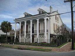 The Dufour Plassan House with its "cornstalk fence" is a neighborhood landmark | |
| Country | United States |
|---|---|
| State | Louisiana |
| City | New Orleans |
| Planning District | District 4, Mid-City District |
| Elevation | 0 ft (0.0 m) |
| Coordinates | 29°58′31″N 90°05′10″W / 29.97528°N 90.08611°WCoordinates: 29°58′31″N 90°05′10″W / 29.97528°N 90.08611°W |
| Area | 0.42 sq mi (1.1 km2) |
| - land | 0.42 sq mi (1 km2) |
| - water | 0.00 sq mi (0 km2), 0% |
| Population | 2,027 (2010) |
| Density | 4,826/sq mi (1,863/km2) |
| Timezone | CST (UTC-6) |
| - summer (DST) | CDT (UTC-5) |
| Area code | 504 |
Bayou St. John is a neighborhood of the city of New Orleans. A subdistrict of the Mid-City area, its boundaries as defined by the City Planning Commission are: Esplanade Avenue to the north, North Broad Street to the east, St. Louis Street to the south, and Bayou St. John (the waterway) to the west.
Geography
According to the United States Census Bureau, the district has a total area of 0.42 square miles (1.1 km2),.
Adjacent neighborhoods
- Faubourg St. John
- Fairgrounds (north)
- Tremé (east)
- Mid-City (west)
- City Park (west)
Boundaries
The City Planning Commission defines the boundaries of Bayou St. John as these streets: Esplanade Avenue, North Broad Street, St. Louis Street and Bayou St. John.[1]
Demographics
As of the census of 2000, there were 4,861 people, 2,113 households, and 1,082 families residing in the neighborhood.[2] The population density was 11,574 /mi² (4,419 /km²).
As of the census of 2010, there were 3,529 people, 1,719 households, and 747 families residing in the neighborhood.[3]
See also
References
- ↑ Greater New Orleans Community Data Center. "Bayou St. John Neighborhood". Archived from the original on 11 June 2008. Retrieved 2008-06-21.
- ↑ "Bayou St. John Neighborhood". Greater New Orleans Community Data Center. Retrieved 5 January 2012.
- ↑ "Bayou St. John Neighborhood". Greater New Orleans Community Data Center. Retrieved 5 January 2012.