Bazaar Township, Chase County, Kansas
| Bazaar Township | |
|---|---|
| Township | |
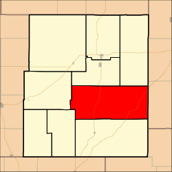 Location within Chase County | |
 Bazaar Township | |
| Coordinates: 38°15′10″N 096°29′31″W / 38.25278°N 96.49194°WCoordinates: 38°15′10″N 096°29′31″W / 38.25278°N 96.49194°W | |
| Country | United States |
| State | Kansas |
| County | Chase |
| Area | |
| • Total | 113.13 sq mi (293 km2) |
| • Land | 112.94 sq mi (292.5 km2) |
| • Water | 0.19 sq mi (0.5 km2) 0.17% |
| Elevation | 1,368 ft (417 m) |
| Population (2000) | |
| • Total | 81 |
| • Density | 0.7/sq mi (0.3/km2) |
| GNIS feature ID | 0477413 |
Bazaar Township is a township in Chase County, Kansas, United States. As of the 2000 census, its population was 81.
Geography
Bazaar Township covers an area of 113.13 square miles (293.0 km2). The streams of Baker Creek, Den Creek, East Branch Sharpes Creek, Folsom Creek, Kirk Creek, Nickel Creek, Norton Creek, Rock Creek, Sharpes Creek and Yeager Creek run through this township.
In what remains of the community of Bazaar, the Bazaar United Methodist Church continues to hold weekly worship services at 8:30 each Sunday morning except for the first weekend in June when Chase County churches meet at the Strong City Rodeo grounds for Cowboy Church.
Communities
The township contains the following settlements:
- Unincorporated community of Bazaar.
Cemeteries
The township contains the following cemeteries:
- Bazaar.
See also
- TWA Flight 599, known as the "Knute Rockne plane crash"
Further reading
See also: List of books about Chase County, Kansas
References
External links
- Chase County Website
- City-Data.com
- Chase County Maps: Current, Historic, KDOT
Municipalities and communities of Chase County, Kansas, United States | ||
|---|---|---|
| Cities | 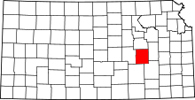 | |
| Unincorporated communities | ||
| Ghost towns | ||
| Townships | ||
| Footnotes | ‡This populated place also has portions in an adjacent county or counties | |
This article is issued from Wikipedia - version of the 3/31/2016. The text is available under the Creative Commons Attribution/Share Alike but additional terms may apply for the media files.