Matfield Green, Kansas
| Matfield Green, Kansas | |
|---|---|
| City | |
 Location within Chase County and Kansas | |
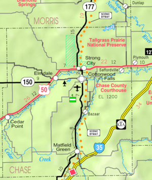 KDOT map of Chase County (legend) | |
| Coordinates: 38°9′35″N 96°33′43″W / 38.15972°N 96.56194°WCoordinates: 38°9′35″N 96°33′43″W / 38.15972°N 96.56194°W | |
| Country | United States |
| State | Kansas |
| County | Chase |
| Township | Matfield |
| Government | |
| • Type | Mayor–Council |
| Area[1] | |
| • Total | 0.14 sq mi (0.36 km2) |
| • Land | 0.14 sq mi (0.36 km2) |
| • Water | 0 sq mi (0 km2) |
| Elevation | 1,316 ft (401 m) |
| Population (2010)[2] | |
| • Total | 47 |
| • Estimate (2015)[3] | 45 |
| • Density | 340/sq mi (130/km2) |
| Time zone | Central (CST) (UTC-6) |
| • Summer (DST) | CDT (UTC-5) |
| ZIP code | 66862 |
| Area code | 620 |
| FIPS code | 20-45150[4] |
| GNIS feature ID | 0477807[5] |
Matfield Green is a city in Chase County, Kansas, United States. As of the 2010 census, the city population was 47.[6]
History
Early history
For many millennia, the Great Plains of North America was inhabited by nomadic Native Americans. The historic Native American tribes of Kansas are many, including the Kansa, or "Wind People," from whom the name of the state is derived. Also included are the related Osage, Pawnee, and Wichita. From the west and north ranged the Comanche and Apache, as well as the Kiowa, Cheyenne and Arapaho.[7]
From the 16th century to 18th century, the Kingdom of France claimed ownership of large parts of North America. In 1762, after the French and Indian War, France secretly ceded New France to Spain, per the Treaty of Fontainebleau.
19th century
In 1802, Spain returned most of the land to France. In 1803, most of the land for modern day Kansas was acquired by the United States from France as part of the 828,000 square mile Louisiana Purchase for 2.83 cents per acre.
In 1854, the Kansas Territory was organized, then in 1861 Kansas became the 34th U.S. state. In 1859, Chase County was established within the Kansas Territory, which included the land for modern day Matfield Green.
Matfield Green was named after Matfield, in England.[8]
In 1870, Bazaar Township, Chase County, Kansas which includes Matfield Green had a population of 376, growing to 1,096 by 1880.[9] In its heyday, at the beginning of the 19th century, Matfield Green grew to about 350 residents and possessed a bank, grocery store, livery and blacksmith, hardware, flour mill and lumberyard, and even a hotel for visitors. It also had its own schools. A post office existed in Matfield Green from January 11, 1867 to September 30, 1995.[10]
Present
Like many small towns in Kansas, Matfield Green struggles to maintain its existence. It is helped by a small colony of artists and writers who work to preserve the community, along with the nearby historic Pioneer Bluffs ranch headquarters.[11]
Geography

Matfield Green is located at 38°09′35″N 96°33′43″W / 38.159609°N 96.562013°W (38.159609, -96.562013).,[12] in the scenic Flint Hills[13] of the Great Plains. According to the United States Census Bureau, the city has a total area of 0.14 square miles (0.36 km2), all of it land.[1]
Climate
The climate in this area is characterized by hot, humid summers and generally mild to cool winters. According to the Köppen Climate Classification system, Matfield Green has a humid subtropical climate, abbreviated "Cfa" on climate maps.[14]
Area attractions
Matfield Green has two ranches on the National Register of Historic Places (NRHP): Crocker Ranch[15] (NRHP). 1908-1940 Pioneer Bluffs Ranch[16] (NRHP), approximately 1 mile north on K-177 Highway. Pioneer Bluffs is an early twentieth century ranch, consisting of one dozen vintage farm buildings.[17][18]
Demographics
| Historical population | |||
|---|---|---|---|
| Census | Pop. | %± | |
| 1880 | 324 | — | |
| 1930 | 182 | — | |
| 1940 | 146 | −19.8% | |
| 1950 | 119 | −18.5% | |
| 1960 | 95 | −20.2% | |
| 1970 | 77 | −18.9% | |
| 1980 | 71 | −7.8% | |
| 1990 | 33 | −53.5% | |
| 2000 | 60 | 81.8% | |
| 2010 | 47 | −21.7% | |
| Est. 2015 | 45 | [3] | −4.3% |
| U.S. Decennial Census | |||
Matfield Green is part of the Emporia Micropolitan Statistical Area.
2010 census
As of the census[2] of 2010, there were 47 people, 24 households, and 11 families residing in the city. The population density was 335.7 inhabitants per square mile (129.6/km2). There were 36 housing units at an average density of 257.1 per square mile (99.3/km2). The racial makeup of the city was 100.0% White.
There were 24 households of which 16.7% had children under the age of 18 living with them, 41.7% were married couples living together, 4.2% had a male householder with no wife present, and 54.2% were non-families. 37.5% of all households were made up of individuals and 16.6% had someone living alone who was 65 years of age or older. The average household size was 1.96 and the average family size was 2.73.
The median age in the city was 58.8 years. 17% of residents were under the age of 18; 0.0% were between the ages of 18 and 24; 12.8% were from 25 to 44; 34.1% were from 45 to 64; and 36.2% were 65 years of age or older. The gender makeup of the city was 51.1% male and 48.9% female.
2000 census
As of the census[4] of 2000, there were 60 people, 31 households, and 18 families residing in the city. The population density was 314.9 people per square mile (121.9/km2). There were 34 housing units at an average density of 178.4 per square mile (69.1/km2). The racial makeup of the city was 100.00% White.
There were 31 households out of which 29.0% had children under the age of 18 living with them, 45.2% were married couples living together, and 41.9% were non-families. 38.7% of all households were made up of individuals and 22.6% had someone living alone who was 65 years of age or older. The average household size was 1.94 and the average family size was 2.56.
In the city the population was spread out with 20.0% under the age of 18, 1.7% from 18 to 24, 23.3% from 25 to 44, 31.7% from 45 to 64, and 23.3% who were 65 years of age or older. The median age was 49 years. For every 100 females there were 114.3 males. For every 100 females age 18 and over, there were 128.6 males.
As of 2000 the median income for a household in the city was $27,500, and the median income for a family was $29,375. Males had a median income of $23,750 versus $14,375 for females. The per capita income for the city was $17,642. There were 19.0% of families and 19.4% of the population living below the poverty line, including 35.7% of under eighteens and none of those over 64.
Government
The Matfield Green government consists of a mayor and five council members. The council meets the 1st Monday of each month at 7PM.[19]
- City Hall, 302 Orient Street.
Education
Primary and secondary education
Cottonwood Falls is part of Unified School District 284.[20][21] All students attend schools in Cottonwood Falls.
- Chase County Junior/Senior High School, 600 Main St in Cottonwood Falls.
- Chase County Elementary School, 401 Maple St in Cottonwood Falls.
Infrastructure
Transportation
K-177 highway and BNSF Railway both pass through Matfield Green. The Kansas Turnpike toll road is close to Matfield Green, but a driver must exit the toll plaza in Cassoday and enter K-177 (Kansas highway) going north.
Utilities
- Internet
- TV
- Satellite TV is provided by DirecTV, Dish Network.
- Free over-the-air ATSC digital TV.
See also
- National Register of Historic Places listings in Chase County, Kansas
- Crocker Ranch
- Pioneer Bluffs Ranch Historic District
Further reading
References
- 1 2 "US Gazetteer files 2010". United States Census Bureau. Retrieved 2012-07-06.
- 1 2 "American FactFinder". United States Census Bureau. Retrieved 2012-07-06.
- 1 2 "Annual Estimates of the Resident Population for Incorporated Places: April 1, 2010 to July 1, 2015". Retrieved July 2, 2016.
- 1 2 "American FactFinder". United States Census Bureau. Retrieved 2008-01-31.
- ↑ "US Board on Geographic Names". United States Geological Survey. 2007-10-25. Retrieved 2008-01-31.
- ↑ "2010 City Population and Housing Occupancy Status". U.S. Census Bureau. Retrieved March 6, 2011.
- ↑ Emporia State University, The Historic Indians of Kansas. http://www.emporia.edu/cgps/tales/o93tales.html
- ↑ Heim, Michael (2007). Exploring Kansas Highways. p. 12.
- ↑ William G. Cutler's History of the State of Kansas, 1883, Chase County, Bazaar Township. http://www.kancoll.org/books/cutler/chase/chase-co-p1.html#TOC
- ↑ "Kansas Post Offices, 1828-1961 (archived)". Kansas Historical Society. Archived from the original on October 9, 2013. Retrieved 5 June 2014.
- ↑ Center for Living Education , Matfield Green. http://www.matfieldgreen.org/thebank/center-for-living-education/
- ↑ "US Gazetteer files: 2010, 2000, and 1990". United States Census Bureau. 2011-02-12. Retrieved 2011-04-23.
- ↑ Flint Hills Tourism Coalition
- ↑ Climate Summary for Matfield Green, Kansas
- ↑ National Register of Historic Places - Crocker Ranch
- ↑ National Register of Historic Places - Pioneer Bluffs Ranch
- ↑ Pioneer Bluffs Ranch web site
- ↑ 'PrairyErth' returns home; The Wichita Eagle, July 17, 2010
- ↑ Matfield Green - Directory of Public Officials
- ↑ USD 284
- ↑ Kansas School District Boundary Map
External links
| Wikimedia Commons has media related to Matfield Green, Kansas. |
- City
- Schools
- USD 284, school district for all of Chase County.
- Historical
- Matfield Green, a "Quiet" town in Chase County, Kansas, History and photographs.
- TWA Flight 599 Memorial, Knute Rockne crash site.
- Maps
- Matfield Green City Map, KDOT
- Topo Map of Matfield Green area, USGS
- Chase County Maps: Current, Historic, KDOT
Municipalities and communities of Chase County, Kansas, United States | ||
|---|---|---|
| Cities | 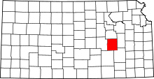 | |
| Unincorporated communities | ||
| Ghost towns | ||
| Townships | ||
| Footnotes | ‡This populated place also has portions in an adjacent county or counties | |