Beatty, Oregon
| Beatty | |
|---|---|
| Unincorporated community | |
 Beatty  Beatty Location within the state of Oregon | |
| Coordinates: 42°26′31″N 121°16′11″W / 42.44194°N 121.26972°WCoordinates: 42°26′31″N 121°16′11″W / 42.44194°N 121.26972°W | |
| Country | United States |
| State | Oregon |
| County | Klamath |
| Time zone | Pacific (PST) (UTC-8) |
| • Summer (DST) | PDT (UTC-7) |
| ZIP codes | 97621 |
Beatty is an unincorporated community in Klamath County, Oregon, United States. Beatty is located on Oregon Route 140 at the confluence of the Sycan and Sprague Rivers and is 30 miles (48 km) east of Klamath Falls.
Beatty was named for J .L. Beatty, a missionary who lived nearby when the area was in the Klamath Indian Reservation. The post office in Beatty, ZIP code 97621, was established in 1913.[1]
Toby "Winema" Riddle is buried near Beatty.[2]
The OC&E Woods Line State Trail passes through Beatty.[3]
Climate
This region experiences warm (but not hot) and dry summers, with no average monthly temperatures above 71.6 °F (22.0 °C). According to the Köppen Climate Classification system, Beatty has a warm-summer Mediterranean climate, abbreviated "Csb" on climate maps.[4]
References
- ↑ McArthur, Lewis A.; Lewis L. McArthur (2003) [1928]. Oregon Geographic Names (7th ed.). Portland, Oregon: Oregon Historical Society Press. ISBN 0-87595-277-1.
- ↑ Valley Herald, Inc. "Marie Dorion and the Trail of the Pioneers". Winema. Frazier Farmstead Museum. Archived from the original on November 14, 2006. Retrieved October 28, 2006.
- ↑ "OC and E Woods Line State Trail". Oregon Parks and Recreation Department. 2013. Retrieved August 19, 2013.
- ↑ "Beatty, Oregon". Weatherbase. CantyMedia. Retrieved June 19, 2015.
Municipalities and communities of Klamath County, Oregon, United States | ||
|---|---|---|
| Cities | 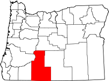 | |
| CDP | ||
| Unincorporated communities | ||