Bee, Nebraska
| Bee, Nebraska | |
|---|---|
| Village | |
|
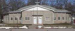
The dodecagonal States Ballroom in Bee is listed in the National Register of Historic Places.[2] | |
 Location of Bee, Nebraska | |
| Coordinates: 41°0′21″N 97°3′29″W / 41.00583°N 97.05806°WCoordinates: 41°0′21″N 97°3′29″W / 41.00583°N 97.05806°W | |
| Country | United States |
| State | Nebraska |
| County | Seward |
| Area[3] | |
| • Total | 0.25 sq mi (0.65 km2) |
| • Land | 0.25 sq mi (0.65 km2) |
| • Water | 0 sq mi (0 km2) |
| Elevation | 1,558 ft (475 m) |
| Population (2010)[4] | |
| • Total | 191 |
| • Estimate (2012[5]) | 191 |
| • Density | 764.0/sq mi (295.0/km2) |
| Time zone | Central (CST) (UTC-6) |
| • Summer (DST) | CDT (UTC-5) |
| ZIP code | 68314 |
| Area code(s) | 402 |
| FIPS code | 31-03600[6] |
| GNIS feature ID | 0827274[7] |
Bee is a village in Seward County, Nebraska, United States. It is part of the Lincoln, Nebraska Metropolitan Statistical Area. The population was 191 at the 2010 census.
History
Bee was laid out in 1887 when the Chicago and North Western Railroad was extended to that point.[8] The village was named from its location in B Township.[9][10]
Geography
Bee is located at 41°0′21″N 97°3′29″W / 41.00583°N 97.05806°W (41.005857, -97.057969).[11]
According to the United States Census Bureau, the village has a total area of 0.25 square miles (0.65 km2), all of it land.[3]
Demographics
| Historical population | |||
|---|---|---|---|
| Census | Pop. | %± | |
| 1910 | 207 | — | |
| 1920 | 228 | 10.1% | |
| 1930 | 205 | −10.1% | |
| 1940 | 205 | 0.0% | |
| 1950 | 160 | −22.0% | |
| 1960 | 149 | −6.9% | |
| 1970 | 156 | 4.7% | |
| 1980 | 192 | 23.1% | |
| 1990 | 209 | 8.9% | |
| 2000 | 223 | 6.7% | |
| 2010 | 191 | −14.3% | |
| Est. 2015 | 193 | [12] | 1.0% |
2010 census
As of the census[4] of 2010, there were 191 people, 78 households, and 53 families residing in the village. The population density was 764.0 inhabitants per square mile (295.0/km2). There were 91 housing units at an average density of 364.0 per square mile (140.5/km2). The racial makeup of the village was 100.0% White. Hispanic or Latino of any race were 3.1% of the population.
There were 78 households of which 28.2% had children under the age of 18 living with them, 53.8% were married couples living together, 10.3% had a female householder with no husband present, 3.8% had a male householder with no wife present, and 32.1% were non-families. 29.5% of all households were made up of individuals and 7.7% had someone living alone who was 65 years of age or older. The average household size was 2.45 and the average family size was 3.02.
The median age in the village was 42.8 years. 23% of residents were under the age of 18; 5.7% were between the ages of 18 and 24; 23.5% were from 25 to 44; 32.4% were from 45 to 64; and 15.2% were 65 years of age or older. The gender makeup of the village was 52.4% male and 47.6% female.
2000 census
As of the census[6] of 2000, there were 223 people, 84 households, and 60 families residing in the village. The population density was 899.2 people per square mile (344.4/km²). There were 89 housing units at an average density of 358.9 per square mile (137.5/km²). The racial makeup of the village was 99.10% White, and 0.90% from two or more races.
There were 84 households out of which 33.3% had children under the age of 18 living with them, 60.7% were married couples living together, 6.0% had a female householder with no husband present, and 27.4% were non-families. 22.6% of all households were made up of individuals and 13.1% had someone living alone who was 65 years of age or older. The average household size was 2.65 and the average family size was 3.13.
In the village the population was spread out with 28.3% under the age of 18, 5.4% from 18 to 24, 33.2% from 25 to 44, 18.8% from 45 to 64, and 14.3% who were 65 years of age or older. The median age was 35 years. For every 100 females there were 110.4 males. For every 100 females age 18 and over, there were 119.2 males.
As of 2000 the median income for a household in the village was $42,917, and the median income for a family was $44,583. Males had a median income of $26,500 versus $18,750 for females. The per capita income for the village was $18,388. About 7.3% of families and 6.6% of the population were below the poverty line, including none of those under the age of 18 and 14.7% of those 65 or over.
References
- ↑ "Nebraska National Register Sites in Seward County". Nebraska State Historical Society. Retrieved 2012-02-22.
- ↑ "Nebraska National Register Sites in Seward County". Nebraska State Historical Society. Retrieved 2012-02-22.
- 1 2 "US Gazetteer files 2010". United States Census Bureau. Archived from the original on 2012-01-24. Retrieved 2012-06-24.
- 1 2 "American FactFinder". United States Census Bureau. Retrieved 2012-06-24.
- ↑ "Population Estimates". United States Census Bureau. Archived from the original on 2013-06-17. Retrieved 2013-05-29.
- 1 2 "American FactFinder". United States Census Bureau. Archived from the original on 2013-09-11. Retrieved 2008-01-31.
- ↑ "US Board on Geographic Names". United States Geological Survey. 2007-10-25. Retrieved 2008-01-31.
- ↑ Waterman, John Henry (1920). General History of Seward County, Nebraska. p. 250.
- ↑ "Bee, Seward County". Center for Advanced Land Management Information Technologies. University of Nebraska. Retrieved 23 August 2014.
- ↑ Chicago and North Western Railway Company (1908). A History of the Origin of the Place Names Connected with the Chicago & North Western and Chicago, St. Paul, Minneapolis & Omaha Railways. p. 42.
- ↑ "US Gazetteer files: 2010, 2000, and 1990". United States Census Bureau. 2011-02-12. Retrieved 2011-04-23.
- ↑ "Annual Estimates of the Resident Population for Incorporated Places: April 1, 2010 to July 1, 2015". Retrieved July 2, 2016.
- ↑ "Census of Population and Housing". Census.gov. Archived from the original on May 11, 2015. Retrieved June 4, 2015.
Municipalities and communities of Seward County, Nebraska, United States | ||
|---|---|---|
| Cities | ||
| Villages | ||
| CDP | ||
| Unincorporated communities | ||
| Ghost town | ||