Beloit, Wisconsin
| City of Beloit, Wisconsin | ||
|---|---|---|
|
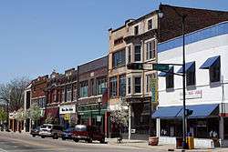
Downtown Beloit | ||
| ||
| Nickname(s): Gateway To Wisconsin | ||
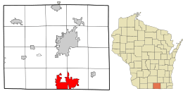 Location in Rock County and the state of Wisconsin. | ||
| Coordinates: 42°30′30″N 89°01′54″W / 42.50833°N 89.03167°W | ||
| Country |
| |
| State |
| |
| County | Rock | |
| Founded | 1836 | |
| Incorporated |
February 24, 1846 (village) March 31, 1856 (city) | |
| Government | ||
| • Manager | Lori Curtis Luther | |
| • City Attorney | Elizabeth Krueger | |
| • City Council |
Charles Haynes (President) Sheila De Forest (Vice President) Regina Hendrix Ana Kelly Charles Kincaid David Luebke Marilyn Sloniker | |
| Area[1] | ||
| • Total | 17.70 sq mi (45.84 km2) | |
| • Land | 17.37 sq mi (44.99 km2) | |
| • Water | 0.33 sq mi (0.85 km2) | |
| Elevation | 751 ft (228.9 m) | |
| Population (2010)[2] | ||
| • Total | 36,966 | |
| • Estimate (2014[3]) | 36,881 | |
| • Density | 2,128/sq mi (821.5/km2) | |
| Website | www.beloitwi.gov | |

Beloit is a city in Rock County, Wisconsin, United States. As of the 2010 census, the city had a population of 36,966.[4][5]
History
Twelve men in Colebrook, New Hampshire created the "New England Emigrating Company" in October 1836 and sent Dr. Horace White to find a suitable region of Wisconsin in which to settle. The level fields and the water power of Turtle Creek and the "unlimited gravel" in the area around what is now Beloit fixed the site of the intended village and farms. White purchased the land. At the same time as the Colebrook settlers, six families from Bedford, New Hampshire arrived and settled in the region. They said that the Rock River Valley had a "New England look", which made them feel at home. The village was platted in 1838 and was planned with wide streets which built on the New England model.
Beloit was originally named New Albany (after Albany, Vermont) in 1837 by its founder, Caleb Blodgett. The name was changed to Beloit in 1838.[6][7] The name Beloit was coined to be reminiscent of Detroit.[6]
Beloit lays claim to such inventions as the speedometer,[8] Korn Kurls,[9] and John Francis Appleby's twine binder.[10] Korn Kurls, which resemble Cheetos, are credited with the founding of the snack food industry.
Historic buildings
Beloit's 1889 Water Tower Place began demolition in 1935, which was halted because of the cost. A historic pump station is located nearby.
The Fairbanks Flats were built in 1917 to house the rush of African Americans moving to the area from the Southern United States.
Pearsons Hall of Science was designed by the architectural firm Burnham and Root for Beloit College to use as a science center.
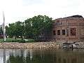
Downtown Beloit and the riverfront
Downtown Beloit is the historical economic, cultural and social center of the community. Located north of the confluence of the Rock River and Turtle Creek, the downtown is anchored by a core of historic buildings and the Ironworks office and industrial campus. Beloit's riverfront park system, mainly Riverside Park, extends north of the downtown along the east bank toward the Town of Beloit.
Downtown Beloit is one of two inaugural members of the Wisconsin Main Street designation.[11]
Railroad heritage
Beloit was served by the Chicago, Milwaukee, St. Paul and Pacific Railroad, better known as the Milwaukee Road, and the Chicago & North Western Railroad (C&NW). In its 1980 bankruptcy, the Milwaukee Road disposed of the Southwestern Line. The Union Pacific Railroad, which took over the C&NW, operates in Beloit today over a remnant of the former Milwaukee Road, providing a rail connection to Fairbanks-Morse Engine. The Canadian Pacific Railway operates other trackage in Beloit.[12] The city also had an electric interurban railroad.
Geography
According to the United States Census Bureau, the city has a total area of 17.70 square miles (45.84 km2), of which 17.37 square miles (44.99 km2) is land and 0.33 square miles (0.85 km2) is water.[1] Location: 42°30′30″N 89°01′54″W / 42.50833°N 89.03167°W.
The city is located adjacent to the Town of Beloit, Town of Turtle, and the Illinois municipality of South Beloit.
Most of Beloit's development is occurring on the east side, adjacent to Interstates 39/90 and Interstate 43, where the city annexed rural land for the extensive Beloit Gateway Industrial Park, as well as in the newly revitalized downtown located along the Rock River.
Demographics
| Historical population | |||
|---|---|---|---|
| Census | Pop. | %± | |
| 1860 | 4,098 | — | |
| 1870 | 4,396 | 7.3% | |
| 1880 | 4,790 | 9.0% | |
| 1890 | 6,315 | 31.8% | |
| 1900 | 10,436 | 65.3% | |
| 1910 | 15,125 | 44.9% | |
| 1920 | 21,284 | 40.7% | |
| 1930 | 23,611 | 10.9% | |
| 1940 | 25,365 | 7.4% | |
| 1950 | 29,590 | 16.7% | |
| 1960 | 32,846 | 11.0% | |
| 1970 | 35,729 | 8.8% | |
| 1980 | 35,207 | −1.5% | |
| 1990 | 35,573 | 1.0% | |
| 2000 | 35,775 | 0.6% | |
| 2010 | 36,966 | 3.3% | |
| Est. 2015 | 36,891 | [13] | −0.2% |
2010 census
As of the census[2] of 2010, there were 36,966 people, 13,781 households, and 8,867 families residing in the city. The population density was 2,128.2 inhabitants per square mile (821.7/km2). There were 15,177 housing units at an average density of 873.7 per square mile (337.3/km2). The racial makeup of the city was 68.9% White, 15.1% African American, 0.4% Native American, 1.1% Asian, 10.0% from other races, and 4.4% from two or more races. Hispanic or Latino of any race were 17.1% of the population.
There were 13,781 households of which 36.5% had children under the age of 18 living with them, 39.6% were married couples living together, 18.3% had a female householder with no husband present, 6.4% had a male householder with no wife present, and 35.7% were non-families. 29.4% of all households were made up of individuals and 11.2% had someone living alone who was 65 years of age or older. The average household size was 2.57 and the average family size was 3.16.
The median age in the city was 33.1 years. 27.1% of residents were under the age of 18; 12.1% were between the ages of 18 and 24; 25.7% were from 25 to 44; 23.1% were from 45 to 64; and 12% were 65 years of age or older. The gender makeup of the city was 47.9% male and 52.1% female.
Government
Beloit is represented by Janis Ringhand and Stephen Nass in the Wisconsin State Senate, Amy Loudenbeck and Mark Spreitzer in the Wisconsin State Assembly, Mark Pocan in the United States House of Representatives, and Ron Johnson and Tammy Baldwin in the United States Senate.
Economy
Beloit's major industries:
- ABC Supply Company †
- Acculynx
- Beloit Daily News
- Bio-Systems International †
- Broaster Company †
- Chicago Fittings
- Comply365
- Fairbanks-Morse
- FatWallet†
- Frito Lay
- Genecor International Wisconsin, Inc. (A DuPont Division)
- Hormel
- Kerry Ingredients & Flavours Americas (A Kerry Group Division)
- Kettle Foods
- Metso
- Murmac Paint Manufacturing, Inc. †
- NorthStar Medical Radioisotopes
- Patch Products †
- Pratt Industries
- Regal-Beloit †
- Staples, Inc. Online Fulfillment Center
† indicates Beloit is home to the company's world headquarters.
Downtown Beloit is a dense cluster of mostly small shops and boutiques. The area has been recognized for increased investment and renewal since the 1990s.[15] Upscale downtown condominiums and hotels were introduced post-2000 with the construction of the Hotel Hilton Apartments (2001), the Beloit Inn (now the Ironworks Hotel) (2003), Heritage View (2005), and the Phoenix Project (2013).
From the 1990s to 2011, downtown Beloit has received direct public and private investment totaling more than $75 million.[15] In 2011, Beloit was a Great American Main Street Award winner.[16] In 2012, Beloit was listed #17 on Travel and Leisure's list of America's Greatest Mainstreets.[17][18]
Education
The School District of Beloit serves more than 7,400 students in six primary schools, four intermediate schools, and one high school, with alternative programming and charter schools. Beloit Memorial High School is the city's public high school. The Roy Chapman Andrews Academy, a project-based charter school, is part of the School District of Beloit and serves grades 6 through 12.
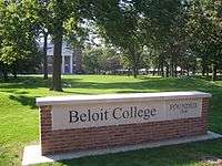
Beloit College, a private liberal arts college with undergraduate enrollment around 1,300, is located in the city. The campus has a number of prehistoric Indian mounds.
Blackhawk Technical College, a public technical school, has a campus in downtown Beloit.
National Louis University also has a campus in Beloit.
Culture
- The Angel Museum
- Beloit Civic Theatre
- Beloit Fine Arts Incubator
- Beloit Historical Society
- Beloit International Film Festival
- Logan Museum of Anthropology
- Rock River Philharmonic
- Turtle Creek Chamber Orchestra
- Wright Museum of Art
Festivals
Beloit's main festivals include:
- Beloit International Film Festival
- Winterfest
- Beloit Heritage Days
- Beloit Autorama
- Music at Harry's Place
Recreation
Beloit is home to a professional minor league baseball team, the Beloit Snappers. The Snappers are a part of the Oakland Athletics organization.
Recognition
- Beloit is the only city in Rock County to have been named an All-America City.[19]
- Beloit was one of Travel + Leisure's top 20 Greatest American Main Streets[20] for 2014.
- The 2015 Milken Institute Best-Performing Cities Index ranked the Janesville-Beloit metropolitan area #4 by how well they created and sustained jobs and economic growth.
Notable people
- Thomas Ryum Amlie, U.S. Representative
- Marcia Anderson, U. S. Army Major General
- Roy Chapman Andrews, adventurer and naturalist
- Fred Ascani, U.S. Air Force Major General
- Alan E. Ashcraft, Jr., Illinois State Representative
- Clinton Babbitt, U.S. Representative
- George B. Belting, Wisconsin State Assemblyman
- Jim Breton, MLB player
- Jason W. Briggs, leader in the development of the Reorganized Church of Jesus Christ of Latter Day Saints
- Tony Brizzolara, MLB player
- Richard Burdge, Wisconsin State Senator
- Jackson J. Bushnell, educator
- Jim Caldwell, Beloit Memorial High School Alumnus and head coach of the Detroit Lions
- Thomas Chrowder Chamberlin, geologist
- Franklin Clarke, professional football player for the Dallas Cowboys (1960–1967) and the Cleveland Browns (1957–1959)
- Lawrence E. Cunningham, Wisconsin State Senator
- Horatio N. Davis, Wisconsin State Senator
- Delmar DeLong, Wisconsin State Assemblyman
- Burger M. Engebretson, Wisconsin State Assemblyman
- John E. Erickson, NBA executive
- Betty Everett, rock and jazz singer ("The Shoop Shoop Song")
- The Felix Culpa, post-hardcore band
- Dorr Felt, inventor of the comptometer
- Edwin G. Fifield, Wisconsin State Assemblyman
- Bill Flannigan, NFL player
- Patsy Gharrity, MLB player
- Danny Gokey, American Idol contestant, choir director at a Beloit church
- Bernie Graham, professional baseball player
- John Hackett, businessman and politician
- Jim Hall, professional boxer
- Edward F. Hansen, Wisconsin State Assemblyman
- William O. Hansen, Wisconsin State Assemblyman
- Bill Hanzlik, NBA player and coach
- Jonathan Harr, journalist and author of (A Civil Action)
- Ken Hendricks, founder of ABC Supply, listed on the Forbes 400
- William H. Hurlbut, Wisconsin State Assemblyman
- Gary Johnson, elected majority leader of the Wisconsin Assembly in 1980 and 1983[21]
- Jerry Kenney, major league baseball player for the New York Yankees (1967, 1969–1972) and the Cleveland Indians (1973)
- John Baxter Kinne, Medal of Honor recipient
- Gene Knutson, NFL player
- Richard LaPiere, sociologist at Stanford University
- Eugene Lee, Tony Award-winning set designer (Wicked, Saturday Night Live)
- Wallace Leschinsky, Wisconsin State Assemblyman
- Alonzo J. Mathison, Wisconsin State Assemblyman
- Max Maxfield, Wyoming Secretary of State
- Juan Conway McNabb (John Conway McNabb), Roman Catholic bishop, missionary-Peru
- Dr. Edward Strong Merrill, Wisconsin Athletic Hall of Fame, legendary multi-sport athlete, Beloit College, '02[22]
- Sereno Merrill, Wisconsin State Assemblyman
- Elmer Miller, MLB player
- Tommy Mills, head coach of the Creighton Bluejays, Georgetown Hoyas and Arkansas State Indians football teams; Creighton Bluejays and Arkansas State Indians men's basketball teams and the Notre Dame Fighting Irish baseball team
- Orsen N. Nielsen, U.S. diplomat
- David Noggle, Wisconsin State Assemblyman, Chief Justice of the Supreme Court of the Idaho Territory
- Russ Oltz, NFL player
- Danica Patrick, Auto racing driver and model
- George Perring, MLB player
- Samuel L. Plummer, Wisconsin State Assemblyman
- Alan S. Robertson, Wisconsin State Assemblyman
- Robert P. Robinson, Wisconsin State Senator
- Judy Robson, former majority leader, Wisconsin Senate
- David Roth, opera director
- Jane Sherman, actress, writer, composer, dancer with The Rockettes
- Richard Shoemaker, Wisconsin State Senator
- Tracy Silverman, violinist
- Erastus G. Smith, Wisconsin State Assemblyman
- Simon Smith, Wisconsin State Assemblyman
- Robert C. Strong, U.S. diplomat
- William Barstow Strong, former president of Atchison, Topeka and Santa Fe Railway
- Tyree Talton, NFL player
- Rusty Tillman, NFL player and assistant coach, XFL head coach
- S. J. Todd, Wisconsin State Senator
- Arthur Pratt Warner, aviator and inventor
- Kyle Weaver, professional basketball player for the Oklahoma City Thunder
- Floyd E. Wheeler, Wisconsin State Assemblyman and lawyer
- John D. Wickhem, Justice of the Wisconsin Supreme Court
- Albert J. Winegar, Wisconsin State Assemblyman
- Zip Zabel, MLB player
- Robin Zander, musician (Cheap Trick)
Images
-

Fairbanks-Morse
-
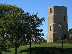
Beloit Water Tower, constructed in 1889
-
Beloit Ironworks, a group of restored industrial buildings along the city's downtown riverfront
-

Middle College, on the Beloit College campus, Wisconsin's oldest academic building still in use
References
- 1 2 "US Gazetteer files 2010". United States Census Bureau. Archived from the original on 2012-07-14. Retrieved 2012-11-18.
- 1 2 "American FactFinder". United States Census Bureau. Retrieved 2012-11-18.
- ↑ "Population Estimates". United States Census Bureau. Retrieved 2016-01-25.
- ↑ "American FactFinder". United States Census Bureau. Archived from the original on 2013-09-11. Retrieved 2008-01-31.
- ↑ "Archived copy". Archived from the original on 2014-03-05. Retrieved 2012-04-19.
- 1 2 Callary, Edward. 2009. Place Names of Illinois. Champaign: University of Illinois Press, p. 326.
- ↑ "Frank Blodgett Dies at Age 82". Janesville Daily Gazette. March 21, 1949. p. 1. Retrieved August 26, 2014 – via Newspapers.com.

- ↑ Arthur Warner
- ↑ Beloit Historical Society Archived July 8, 2008, at the Wayback Machine.
- ↑ Appleby, John Francis 1840 - 1917 Archived February 10, 2009, at the Wayback Machine.
- ↑ "Wisconsin Main Street map and founding years" (PDF). Wisconsin Main Street Association. Retrieved 26 September 2013.
- ↑ Beloit Railroad History and Photos
- ↑ "Annual Estimates of the Resident Population for Incorporated Places: April 1, 2010 to July 1, 2015". Retrieved July 2, 2016.
- ↑ "Census of Population and Housing". Census.gov. Archived from the original on May 11, 2015. Retrieved June 4, 2015.
- 1 2 "The 2011 Great American Main Street Award Winners". Preservation Nation. Retrieved 26 September 2013.
- ↑ Stewart, Erica (23 May 2011). "The 2011 Great American Main Street Award Winners: Places You'll Want to Know (and Visit!)". PreservationNation Blog. Retrieved 26 September 2013.
- ↑ "America's Greatest Mainstreets 2012".
- ↑ Adams, Barry. "Downtown Beloit an Emerging Destination". Wisconsin State Journal. Retrieved 24 March 2014.
- ↑ http://www.ci.beloit.wi.us/index.asp?Type=B_BASIC&SEC={AA77531B-C0D5-4BC2-A0AE-B58551C3F8C7}
- ↑ http://www.travelandleisure.com/articles/americas-greatest-main-streets/16
- ↑ http://www.legis.state.wi.us/spotlight/spotl339.htm
- ↑ Wisconsin Athletic Hall of Fame, 1964 inductee
External links
| Wikimedia Commons has media related to Beloit, Wisconsin. |
Municipalities and communities of Rock County, Wisconsin, United States | ||
|---|---|---|
| Cities | 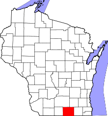 | |
| Villages | ||
| Towns | ||
| CDP | ||
| Unincorporated communities |
| |
| Ghost towns | ||
| Footnotes | ‡This populated place also has portions in an adjacent county or counties | |
Coordinates: 42°30′30″N 89°01′54″W / 42.50833°N 89.03167°W