Shawano County, Wisconsin
| Shawano County, Wisconsin | |
|---|---|
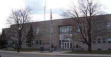 Shawano County Courthouse, built mid-1950s | |
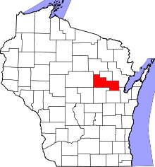 Location in the U.S. state of Wisconsin | |
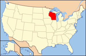 Wisconsin's location in the U.S. | |
| Founded | 1861 |
| Seat | Shawano |
| Largest city | Shawano |
| Area | |
| • Total | 909 sq mi (2,354 km2) |
| • Land | 893 sq mi (2,313 km2) |
| • Water | 16 sq mi (41 km2), 1.8% |
| Population | |
| • (2010) | 41,949 |
| • Density | 47/sq mi (18/km²) |
| Congressional district | 8th |
| Time zone | Central: UTC-6/-5 |
| Website |
www |
Shawano County (originally Shawanaw County) is a county located in the U.S. state of Wisconsin. As of the 2010 census, the population was 41,949.[1] Its county seat is Shawano.[2]
Shawano County is included in the Shawano, WI Micropolitan Statistical Area, which is also included in the Green Bay-Shawano, WI Combined Statistical Area.
History
Its name is from a modified Ojibwa term meaning 'southern';[3][4] it was the southern boundary of the Ojibwa nation.[5] A Menominee chief named Sawanoh led a band that lived in the area.[6] Many citizens of Shawano believe the lake, county, and city (Town of Shawanaw founded 1853 and changed to Shawano in 1856), were named after Chief Sawanoh. A historical marker placed in 1958 near the lake along Highway 22 states the lake was named as the southern boundary of Chippewa (Ojibwe) territory.
Various historical recordings of the spelling of Shawano include: Sawanoh, Shawanaw, Sharuno, Shabin, Savannah, Savanah... which show the influence of French, German, and English translation (v's, w's, and b's, sounding very similar and thus being recorded incorrectly at times). Similar differences in spelling have been seen in the following versions: Mahican/Mahikan/Maikens tribe or Mohecan/Morhican/Mohican tribe, all referring to the same Algonquian-speaking people.
The federally recognized Stockbridge-Munsee Community (made up of Algonquian-speaking Mahican and Lenape), whose ancestors traditionally lived in the East along the Hudson River Valley, is located in Shawano County. Their reservation encompasses the towns of Bartelme, and Red Springs.
The county was created as a separate county in 1853 under the name Shawanaw County. In 1861 it achieved full organization.[7] The county, unlike the city, retained the old spelling until 1864.[8]
From the mid-nineteenth century on, the county was settled by European Americans, including many German, and later, Polish immigrants. They developed the county for agriculture. Before that, French-Canadian and British fur traders traveled widely through the area, trading with the Chippewa and other Native American peoples of the region.
Geography
According to the U.S. Census Bureau, the county has a total area of 909 square miles (2,350 km2), of which 893 square miles (2,310 km2) is land and 16 square miles (41 km2) (1.8%) is water.[9]
Adjacent counties
- Menominee County - north
- Oconto County - east
- Brown County - southeast
- Outagamie County - south
- Waupaca County - south
- Portage County - southwest
- Marathon County - west
- Langlade County - northwest
Major highways
Airport
The city and county jointly operate the Shawano Municipal Airport (KEZS) which is located on Shawano Lake.
Demographics
| Historical population | |||
|---|---|---|---|
| Census | Pop. | %± | |
| 1860 | 829 | — | |
| 1870 | 3,166 | 281.9% | |
| 1880 | 10,371 | 227.6% | |
| 1890 | 19,236 | 85.5% | |
| 1900 | 27,475 | 42.8% | |
| 1910 | 31,884 | 16.0% | |
| 1920 | 33,975 | 6.6% | |
| 1930 | 33,516 | −1.4% | |
| 1940 | 35,378 | 5.6% | |
| 1950 | 35,249 | −0.4% | |
| 1960 | 34,351 | −2.5% | |
| 1970 | 32,650 | −5.0% | |
| 1980 | 35,928 | 10.0% | |
| 1990 | 37,157 | 3.4% | |
| 2000 | 40,664 | 9.4% | |
| 2010 | 41,949 | 3.2% | |
| Est. 2015 | 41,304 | [10] | −1.5% |
| U.S. Decennial Census[11] 1790–1960[12] 1900–1990[13] 1990–2000[14] 2010–2014[1] | |||
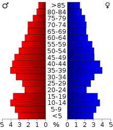
As of the census[15] of 2000, there were 40,664 people, 15,815 households, and 11,149 families residing in the county. The population density was 46 people per square mile (18/km²). There were 18,317 housing units at an average density of 20 per square mile (8/km²). The racial makeup of the county was 91.61% White, 0.22% Black or African American, 6.26% Native American, 0.33% Asian, 0.04% Pacific Islander, 0.31% from other races, and 1.22% from two or more races. 1.00% of the population were Hispanic or Latino of any race. 54.9% were of German and 8.1% Polish ancestry according to Census 2000.
There were 15,815 households out of which 31.50% had children under the age of 18 living with them, 58.30% were married couples living together, 8.00% had a female householder with no husband present, and 29.50% were non-families. 24.90% of all households were made up of individuals and 12.10% had someone living alone who was 65 years of age or older. The average household size was 2.51 and the average family size was 3.00.
In the county, the population was spread out with 25.70% under the age of 18, 6.90% from 18 to 24, 27.50% from 25 to 44, 23.10% from 45 to 64, and 16.80% who were 65 years of age or older. The median age was 38 years. For every 100 females there were 99.80 males. For every 100 females age 18 and over, there were 97.60 males.
Communities


Cities
- Marion (mostly in Waupaca County)
- Shawano (county seat)
Villages
- Aniwa
- Birnamwood (partly in Marathon County)
- Bonduel
- Bowler
- Cecil
- Eland
- Gresham
- Mattoon
- Pulaski (mostly in Brown County and Oconto County)
- Tigerton
- Wittenberg
Towns
Census-designated places
Unincorporated communities
See also
References
- 1 2 "State & County QuickFacts". United States Census Bureau. Retrieved January 23, 2014.
- ↑ "Find a County". National Association of Counties. Retrieved 2011-06-07.
- ↑ Shawano county [origin of place name] Archived August 5, 2008, at the Wayback Machine.
- ↑ Shawano's Modern History Began in 1844 with Logging and Later Farming]
- ↑ "Here's How Iron Got Its Name". The Rhinelander Daily News. June 16, 1932. p. 2. Retrieved August 24, 2014 – via Newspapers.com.

- ↑ http://www.shawanocommerce.com/history.html
- ↑ "Wisconsin: Individual County Chronologies". Wisconsin Atlas of Historical County Boundaries. The Newberry Library. 2007. Retrieved August 15, 2015.
- ↑ Erickson, Halford, ed. The blue book of the state of Wisconsin 1903 Madison, 1903; p. 116
- ↑ "2010 Census Gazetteer Files". United States Census Bureau. August 22, 2012. Retrieved August 9, 2015.
- ↑ "County Totals Dataset: Population, Population Change and Estimated Components of Population Change: April 1, 2010 to July 1, 2015". Retrieved July 2, 2016.
- ↑ "U.S. Decennial Census". United States Census Bureau. Retrieved August 9, 2015.
- ↑ "Historical Census Browser". University of Virginia Library. Retrieved August 9, 2015.
- ↑ Forstall, Richard L., ed. (March 27, 1995). "Population of Counties by Decennial Census: 1900 to 1990". United States Census Bureau. Retrieved August 9, 2015.
- ↑ "Census 2000 PHC-T-4. Ranking Tables for Counties: 1990 and 2000" (PDF). United States Census Bureau. April 2, 2001. Retrieved August 9, 2015.
- ↑ "American FactFinder". United States Census Bureau. Retrieved 2011-05-14.
Further reading
- Commemorative Biographical Record of the Upper Wisconsin Counties of Waupaca, Portage, Wood, Marathon, Lincoln, Oneida, Vilas, Langlade and Shawano. Chicago: J. H. Beers, 1895.
External links
- Shawano County
- Shawano County map from the Wisconsin Department of Transportation
- Shawano Country Tourism
- Shawano County Barns Adorned With Colorful Barn Quilts Video produced by Wisconsin Public Television
Municipalities and communities of Shawano County, Wisconsin, United States | ||
|---|---|---|
| Cities | | |
| Villages | ||
| Towns | ||
| CDPs | ||
| Unincorporated communities | ||
| Indian reservations | ||
| Footnotes | ‡This populated place also has portions in an adjacent county or counties | |
Coordinates: 44°47′N 88°46′W / 44.79°N 88.76°W