Mount Pleasant, Wisconsin
| Mount Pleasant, Wisconsin | ||
|---|---|---|
| Village | ||
 | ||
| ||
| Motto: A Forward Thinking Community... | ||
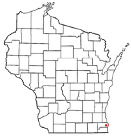 Location of Mount Pleasant, Wisconsin | ||
| Coordinates: 42°43′4″N 87°53′11″W / 42.71778°N 87.88639°WCoordinates: 42°43′4″N 87°53′11″W / 42.71778°N 87.88639°W | ||
| Country | United States | |
| State | Wisconsin | |
| County | Racine | |
| Settled | 1835 | |
| Township | 1842 | |
| Incorporated | September 16, 2003 | |
| Government | ||
| • Type | Board of Trustees | |
| • President | Mark Gleason | |
| Area[1] | ||
| • Total | 35.35 sq mi (91.56 km2) | |
| • Land | 33.73 sq mi (87.36 km2) | |
| • Water | 1.62 sq mi (4.20 km2) | |
| Elevation | 715 ft (218 m) | |
| Population (2010)[2] | ||
| • Total | 26,197 | |
| • Estimate (2012[3]) | 26,185 | |
| • Density | 776.7/sq mi (299.9/km2) | |
| Time zone | CST (UTC-6) | |
| • Summer (DST) | CDT (UTC-5) | |
| Area code(s) | 262 | |
| GNIS feature ID | 2012620 | |
| Website | www.mtpleasantwi.gov/ | |
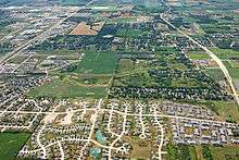
Mount Pleasant is a village in Racine County, Wisconsin, in the United States. It is located approximately 30 miles (50 km) south of Milwaukee and 60 miles (100 km) north of Chicago. As of the 2010 census, the village population was 26,197, making it the 2nd most populous village in the State of Wisconsin[4] and the 29th most populous municipality in the State of Wisconsin.[5]
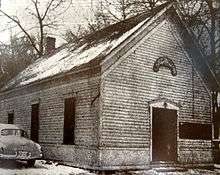
History
The community was established as the Town of Mount Pleasant in 1842 when a small group of residents met to organize the settlement. In 1972, Mount Pleasant adopted its zoning ordinance, which established significant locally controlled development. On September 16, 2003 Mount Pleasant incorporated as a village following a referendum passed by the residents.[6]

Geography
According to the United States Census Bureau, the village has a total area of 35.35 square miles (91.56 km2), of which, 33.73 square miles (87.36 km2) of it is land and 1.62 square miles (4.20 km2) is water.[1] Local Area Code is 262.
Demographics
| Historical population | |||
|---|---|---|---|
| Census | Pop. | %± | |
| 1980 | 19,340 | — | |
| 1990 | 20,084 | 3.8% | |
| 2000 | 23,142 | 15.2% | |
| 2010 | 26,197 | 13.2% | |
| Est. 2015 | 26,272 | [7] | 0.3% |
2010 census
As of the census[2] of 2010, there were 26,197 people, 11,136 households, and 7,395 families residing in the village. The population density was 776.7 inhabitants per square mile (299.9/km2). There were 11,827 housing units at an average density of 350.6 per square mile (135.4/km2). The racial makeup of the village was 86.0% White, 6.7% African American, 0.2% Native American, 2.1% Asian, 2.9% from other races, and 2.0% from two or more races. Hispanic or Latino of any race were 8.3% of the population.
There were 11,136 households of which 26.4% had children under the age of 18 living with them, 54.1% were married couples living together, 8.5% had a female householder with no husband present, 3.9% had a male householder with no wife present, and 33.6% were non-families. 29.2% of all households were made up of individuals and 14.3% had someone living alone who was 65 years of age or older. The average household size was 2.33 and the average family size was 2.86.
The median age in the village was 45.8 years. 20.5% of residents were under the age of 18; 6.5% were between the ages of 18 and 24; 22% were from 25 to 44; 31.3% were from 45 to 64; and 19.8% were 65 years of age or older. The gender makeup of the village was 47.9% male and 52.1% female.
2000 census
As of the census[9] of 2000, there were 23,142 people, 9,453 households, and 6,513 families residing in the village. The population density was 662.6 people per square mile (255.8/km2). There were 9,768 housing units at an average density of 279.7 per square mile (108.0/km2). The racial makeup of the village was 89.17% White, 6.39% African American, 0.26% Native American, 1.21% Asian, 0.03% Pacific Islander, 1.83% from other races, and 1.11% from two or more races. Hispanic or Latino of any race were 4.96% of the population.
There were 9,453 households out of which 27.8% had children under the age of 18 living with them, 58.3% were married couples living together, 7.7% had a female householder with no husband present, and 31.1% were non-families. 27.2% of all households were made up of individuals and 12.8% had someone living alone who was 65 years of age or older. The average household size was 2.40 and the average family size was 2.93.
In the village the population was spread out with 22.3% under the age of 18, 7.0% from 18 to 24, 24.6% from 25 to 44, 27.3% from 45 to 64, and 18.7% who were 65 years of age or older. The median age was 43 years. For every 100 females there were 92.3 males. For every 100 females age 18 and over, there were 88.8 males.
The median income for a household in the village was $52,869, and the median income for a family was $63,937. Males had a median income of $47,871 versus $31,317 for females. The per capita income for the village was $27,123. About 2.9% of families and 4.3% of the population were below the poverty line, including 5.4% of those under age 18 and 5.7% of those age 65 or over.
Government
The Village of Mount Pleasant is governed by a six-member board and a village president. The president and the board are elected by general election for a term of two years per member. The board enacts local ordinances and approves the village budget. Mount Pleasant has an elected village-wide municipal judge.
Village services include a full-time police department, full-time consolidated fire department (South Shore Fire Department), highway/public works department, and in-house building, planning, development, engineering, and finance departments. The village operates and maintains its own sanitary sewer and storm water utilities, with municipal drinking water provided by the city of Racine.
Mount Pleasant is represented by Paul Ryan (R) in the United States House of Representatives, and by Ron Johnson (R) and Tammy Baldwin (D) in the United States Senate. Robert Wirch (D) and Van Wanggaard (R) represent Mount Pleasant in the Wisconsin State Senate, and Robin Vos (R), Tom Weatherston (R), and Peter Barca (D) represent Mount Pleasant in the Wisconsin State Assembly.
- Fire Protection/Ambulance Service from the South Shore Fire Department
- Police Service from the Mount Pleasant Police Department and Racine County Sheriff
Education
Mount Pleasant's public schools are managed by the Racine Unified School District.
The University of Wisconsin–Parkside is located two miles south of Mount Pleasant in Kenosha. Gateway Technical College is nearby.
Notable people
- August J. Piper, Wisconsin State Assemblyman and farmer was born in the Town of Mount Pleasant; Piper served as chairman of the Mount Pleasant Town Board.[10]
- Fred Venturelli, NFL player, was buried in Mount Pleasant.
References
- 1 2 "US Gazetteer files 2010". United States Census Bureau. Retrieved 2012-11-18.
- 1 2 "American FactFinder". United States Census Bureau. Retrieved 2012-11-18.
- ↑ "Population Estimates". United States Census Bureau. Retrieved 2013-06-24.
- ↑ List of villages in Wisconsin
- ↑ List of municipalities in Wisconsin by population
- ↑ History of Mount Pleasant, Wisconsin
- ↑ "Annual Estimates of the Resident Population for Incorporated Places: April 1, 2010 to July 1, 2015". Retrieved July 2, 2016.
- ↑ "Census of Population and Housing". Census.gov. Retrieved June 4, 2015.
- ↑ "American FactFinder". United States Census Bureau. Retrieved 2008-01-31.
- ↑ 'August J. Piper Is Dead,' Racine Journal Times, July 12, 1945, pg. 1
External links
Municipalities and communities of Racine County, Wisconsin, United States | ||
|---|---|---|
| Cities | 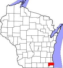 | |
| Villages | ||
| Towns | ||
| CDPs | ||
| Unincorporated communities | ||
| Ghost towns | ||
| Footnotes | ‡This populated place also has portions in an adjacent county or counties | |