Belomorsk
| Belomorsk (English) Беломорск (Russian) Šuomua (Karelian) | |
|---|---|
| - Town[1] - | |
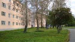 Pashkova Street in Belomorsk | |
.svg.png) Location of the Republic of Karelia in Russia | |
 Belomorsk | |
|
| |
.jpg) | |
|
| |
| Administrative status (as of April 2013) | |
| Country | Russia |
| Federal subject | Republic of Karelia[1] |
| Administrative district | Belomorsky District[1] |
| Administrative center of | Belomorsky District[1] |
| Municipal status (as of April 2013) | |
| Municipal district | Belomorsky Municipal District[2] |
| Urban settlement | Belomorskoye Urban Settlement[2] |
| Administrative center of | Belomorsky Municipal District,[3] Belomorskoye Urban Settlement[2] |
| Statistics | |
| Population (2010 Census) | 11,217 inhabitants[4] |
| Time zone | MSK (UTC+03:00)[5] |
| Founded | September 11, 1938 |
| Town status since | September 11, 1938 |
| Postal code(s)[6] | 186500 |
| Dialing code(s) | +7 81437 |
| Belomorsk on Wikimedia Commons | |
Belomorsk (Russian: Беломо́рск; Karelian: Šuomua; Finnish: Belomorsk/Sorokka[7]) is a town and the administrative center of Belomorsky District of the Republic of Karelia, Russia, located on the Onega Bay on the shore of the White Sea. Population: 11,217 (2010 Census);[4] 13,103 (2002 Census);[8] 18,935 (1989 Census).[9]
History
In the beginning it was a small village named Soroka (Соро́ка), or Sorotskaya (Сороцкая) in the official Russian Imperial statistics. On September 11, 1938, Soroka and several nearby localities were merged to form the town of Belomorsk. In 1941-1944, during World War II, it served as the temporary capital of the Karelo-Finnish Soviet Socialist Republic.
Administrative and municipal status
Within the framework of administrative divisions, Belomorsk serves as the administrative center of Belomorsky District, to which it is directly subordinated.[1] As a municipal division, the town of Belomorsk, together with eleven rural localities, is incorporated within Belomorsky Municipal District as Belomorskoye Urban Settlement.[2]
Culture
Belomorsk is the cultural center of Pomorye. Historical places nearby include Zalavruga and Besovy Sledki with ancient petroglyphs.
Transportation
Belomorsk is situated on the mouth of the White Sea – Baltic Canal. The town can be said to be situated at the entrance to the canal, the end point of the waterway system being in St. Petersburg. The Kirov Railway connects Belomorsk with Murmansk and St. Petersburg. A new port is being constructed in Belomorsk that will have a capacity of nine million tons of cargo by 2014.[10] In a second stage the capacity can be increased to fifteen million tons. The port will not be ice-free year around, but will nevertheless operate without interruption by using icebreakers during winter.
References
Notes
- 1 2 3 4 5 Law #871-RZK
- 1 2 3 4 Law #813-RZK
- ↑ Law #825-ZRK
- 1 2 Russian Federal State Statistics Service (2011). "Всероссийская перепись населения 2010 года. Том 1" [2010 All-Russian Population Census, vol. 1]. Всероссийская перепись населения 2010 года (2010 All-Russia Population Census) (in Russian). Federal State Statistics Service. Retrieved June 29, 2012.
- ↑ Правительство Российской Федерации. Федеральный закон №107-ФЗ от 3 июня 2011 г. «Об исчислении времени», в ред. Федерального закона №271-ФЗ от 03 июля 2016 г. «О внесении изменений в Федеральный закон "Об исчислении времени"». Вступил в силу по истечении шестидесяти дней после дня официального опубликования (6 августа 2011 г.). Опубликован: "Российская газета", №120, 6 июня 2011 г. (Government of the Russian Federation. Federal Law #107-FZ of June 31, 2011 On Calculating Time, as amended by the Federal Law #271-FZ of July 03, 2016 On Amending Federal Law "On Calculating Time". Effective as of after sixty days following the day of the official publication.).
- ↑ Почта России. Информационно-вычислительный центр ОАСУ РПО. (Russian Post). Поиск объектов почтовой связи (Postal Objects Search) (Russian)
- ↑ Venäjän federaation paikannimiä (PDF). Helsinki: Kotimaisten kielten tutkimuskeskus. 2006. p. 32. ISBN 952-5446-18-2. Retrieved 2014-06-24.
- ↑ Russian Federal State Statistics Service (May 21, 2004). "Численность населения России, субъектов Российской Федерации в составе федеральных округов, районов, городских поселений, сельских населённых пунктов – районных центров и сельских населённых пунктов с населением 3 тысячи и более человек" [Population of Russia, Its Federal Districts, Federal Subjects, Districts, Urban Localities, Rural Localities—Administrative Centers, and Rural Localities with Population of Over 3,000] (XLS). Всероссийская перепись населения 2002 года [All-Russia Population Census of 2002] (in Russian). Retrieved August 9, 2014.
- ↑ Demoscope Weekly (1989). "Всесоюзная перепись населения 1989 г. Численность наличного населения союзных и автономных республик, автономных областей и округов, краёв, областей, районов, городских поселений и сёл-райцентров" [All Union Population Census of 1989: Present Population of Union and Autonomous Republics, Autonomous Oblasts and Okrugs, Krais, Oblasts, Districts, Urban Settlements, and Villages Serving as District Administrative Centers]. Всесоюзная перепись населения 1989 года [All-Union Population Census of 1989] (in Russian). Институт демографии Национального исследовательского университета: Высшая школа экономики [Institute of Demography at the National Research University: Higher School of Economics]. Retrieved August 9, 2014.
- ↑ Barents Observer. New port to be constructed near Belomorsk. By Thomas Nielsen, September 9, 2010.
Sources
- Законодательное Собрание Республики Карелия. Закон №871-ЗРК от 29 апреля 2005 г. «Об административно-территориальном устройстве Республики Карелия», в ред. Закона №1895-ЗРK от 2 июня 2015 г. «О внесении изменения статью 9 Закона Республики Карелия "Об административно-территориальном устройстве Республики Карелия"». Вступил в силу со дня официального опубликования. Опубликован: газета "Карелия", №48, 7 мая 2005 г. (Legislative Assembly of the Republic of Karelia. Law #871-ZRK of April 29, 2005 On the Administrative-Territorial Structure of the Republic of Karelia, as amended by the Law #1895-ZRK of June 2, 2015 On Amending Article 9 of the Law of the Republic of Karelia "On the Administrative-Territorial Structure of the Republic of Karelia". Effective as of the official publication date.).
- Законодательное Собрание Республики Карелия. Закон №813-ЗРК от 1 ноября 2004 г. «О городских, сельских поселениях в Республике Карелия», в ред. Закона №1694-ЗРK от 2 апреля 2013 г. «О преобразовании муниципальных образований "Нюхчинское сельское поселение" и "Сумпосадское сельское поселение" Беломорского муниципального района и внесении изменений в некоторые законодательные акты Республики Карелия». Вступил в силу по истечении десяти дней со дня официального опубликования. Опубликован: газета "Карелия", №124, 126, 129, 132, 135, 136, 139, 4 ноября — 9 декабря 2004 г. (Legislative Assembly of the Republic of Karelia. Law #813-ZRK of November 1, 2004 On the Urban, Rural Settlements in the Republic of Karelia, as amended by the Law #1694-ZRK of April 2, 2013 On the Transformation of the Municipal Formations of "Nyukhchinskoye Rural Settlement" and "Sumposadskoye Rural Settlement" of Belomorsky Municipal District of the Republic of Karelia and on Amending Various Legislative Acts of the Republic of Karelia. Effective as of the day which is ten days after the day of the official publication.).
- Законодательное Собрание Республики Карелия. Закон №825-ЗРК от 1 декабря 2004 г. «О муниципальных районах в Республике Карелия», в ред. Закона №1694-ЗРK от 2 апреля 2013 г. «О преобразовании муниципальных образований "Нюхчинское сельское поселение" и "Сумпосадское сельское поселение" Беломорского муниципального района и внесении изменений в некоторые законодательные акты Республики Карелия». Вступил в силу по истечении десяти дней со дня официального опубликования. Опубликован: газета "Карелия", №141, 16 декабря 2004 г. (Legislative Assembly of the Republic of Karelia. Law #825-ZRK of December 1, 2004 On the Municipal Districts in the Republic of Karelia, as amended by the Law #1694-ZRK of April 2, 2013 On the Transformation of the Municipal Formations of "Nyukhchinskoye Rural Settlement" and "Sumposadskoye Rural Settlement" of Belomorsky Municipal District of the Republic of Karelia and on Amending Various Legislative Acts of the Republic of Karelia. Effective as of the day which is ten days after the day of the official publication.).