Bethel, Delaware
| Town of Bethel | |
| Town | |
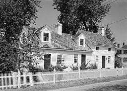 Ship-Carpenter's House | |
| Country | United States |
|---|---|
| State | Delaware |
| County | Sussex |
| Coordinates | 38°34′07″N 75°37′13″W / 38.56861°N 75.62028°WCoordinates: 38°34′07″N 75°37′13″W / 38.56861°N 75.62028°W |
| Area | 0.4 sq mi (1.0 km2) |
| - land | 0.4 sq mi (1 km2) |
| - water | 0.0 sq mi (0 km2) |
| Population | 171 (2010) |
| Density | 427.5/sq mi (165/km2) |
| Timezone | EST (UTC-5) |
| - summer (DST) | EDT (UTC-4) |
| ZIP code | 19931 |
| Area code | 302 |
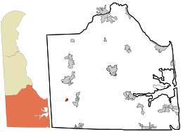 Location in Sussex County and the state of Delaware.
| |
.svg.png) Location of Delaware in the United States
| |
Bethel is a town in Sussex County, Delaware, United States. According to 2010 Census Bureau figures, the population of the town is 171.[1] It is part of the Salisbury, Maryland-Delaware Metropolitan Statistical Area.
History
Bethel is a small, well-preserved 19th century shipbuilding and trading community. Wooden sailing vessels were constructed by Bethel's skilled ship carpenters until the early-20th century. The most significant class of Bethel craft were the Chesapeake sailing rams, which originated from this Broad Creek port.[2]
The town of Bethel was formerly known as both Lewis' Wharf and Lewisville. The site was originally part of five hundred acres granted by the province of Maryland to James Caldwell in 1728. Settlement of this area was inhibited by the continuous boundary disputes between Maryland and the Penn family. In 1795, Kendal Major Lewis, the founder of Bethel, acquired much of James Caldwell's original grant as well as a smaller tract on Broad Creek, known as Mitchell's Harbor. Here he established a landing that grew to become a prosperous trading center. In the 1840s, Lewis' Wharf developed into a thriving community known as Lewisville.[2]
Within the next 20 years, Lewisville was to become an important shipbuilding center. The extensive forests along the Nanticoke provided abundant supplies of virgin pine, oak and cypress. In 1869, Jonathan Moore of Lewisville established the most important marine railway on the peninsula south of Wilmington. John M. C. Moore, superintendent of Lewisville's Marine Railway Company, originated the well-known Chesapeake sailing ram. This class of sailing vessel was designed as an economical, flatbottom, three masted schooner; its operation required only a small crew. Rams were used for coastal freight primarily on the Chesapeake Bay. Between 1871 and 1918, as many as thirty rams were built in Lewisville shipyards.[2]
In 1880, when the village applied for a post office, its name was changed to Bethel, since another Lewisville, Delaware, post office already existed.[2]
The Bethel Historic District was added to the National Register of Historic Places in 1975.[3]
Geography
Bethel is located at 38°34′7″N 75°37′13″W / 38.56861°N 75.62028°W (38.568676, -75.620188).[4]
According to the United States Census Bureau, the town has a total area of 0.4 square miles (1.0 km2), all of it land.
Demographics
| Historical population | |||
|---|---|---|---|
| Census | Pop. | %± | |
| 1880 | 298 | — | |
| 1890 | 378 | 26.8% | |
| 1910 | 370 | — | |
| 1920 | 222 | −40.0% | |
| 1930 | 219 | −1.4% | |
| 1940 | 245 | 11.9% | |
| 1950 | 271 | 10.6% | |
| 1960 | 236 | −12.9% | |
| 1970 | 219 | −7.2% | |
| 1980 | 197 | −10.0% | |
| 1990 | 178 | −9.6% | |
| 2000 | 184 | 3.4% | |
| 2010 | 171 | −7.1% | |
| Est. 2015 | 187 | [5] | 9.4% |
As of the census[7] of 2000, there were 184 people, 78 households, and 56 families residing in the town. The population density was 413.2 people per square mile (157.9/km²). There were 97 housing units at an average density of 217.8 per square mile (83.2/km²). The racial makeup of the town was 96.20% White, 2.72% African American and 1.09% Asian. Hispanic or Latino of any race were 0.54% of the population.
There were 78 households out of which 23.1% had children under the age of 18 living with them, 60.3% were married couples living together, 9.0% had a female householder with no husband present, and 28.2% were non-families. 24.4% of all households were made up of individuals and 12.8% had someone living alone who was 65 years of age or older. The average household size was 2.36 and the average family size was 2.82.
In the town the population was spread out with 20.7% under the age of 18, 7.6% from 18 to 24, 23.9% from 25 to 44, 28.8% from 45 to 64, and 19.0% who were 65 years of age or older. The median age was 44 years. For every 100 females there were 89.7 males. For every 100 females age 18 and over, there were 84.8 males.
The median income for a household in the town was $34,107, and the median income for a family was $58,750. Males had a median income of $33,750 versus $21,500 for females. The per capita income for the town was $25,254. About 3.6% of families and 2.5% of the population were below the poverty line, including none of those under the age of eighteen and 14.3% of those sixty five or over.
References
- ↑ http://www.stateplanning.delaware.gov/census_data_center/
- 1 2 3 4 Madeline Dunn (March 1974). "National Register of Historic Places Inventory/Nomination: Bethel Historic District" (PDF).
- ↑ National Park Service (2010-07-09). "National Register Information System". National Register of Historic Places. National Park Service.
- ↑ "US Gazetteer files: 2010, 2000, and 1990". United States Census Bureau. 2011-02-12. Retrieved 2011-04-23.
- ↑ "Annual Estimates of the Resident Population for Incorporated Places: April 1, 2010 to July 1, 2015". Retrieved July 2, 2016.
- ↑ "Census of Population and Housing". Census.gov. Archived from the original on May 11, 2015. Retrieved June 4, 2015.
- ↑ "American FactFinder". United States Census Bureau. Archived from the original on 2013-09-11. Retrieved 2008-01-31.