Bicester
| Bicester | |
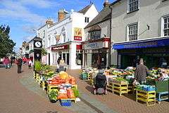 Sheep Street on market day |
|
 Bicester |
|
| Area | 8.58 km2 (3.31 sq mi) |
|---|---|
| Population | 32,642 (2011 Census) |
| – density | 3,804/km2 (9,850/sq mi) |
| OS grid reference | SP5822 |
| Civil parish | Bicester |
| District | Cherwell |
| Shire county | Oxfordshire |
| Region | South East |
| Country | England |
| Sovereign state | United Kingdom |
| Post town | Bicester |
| Postcode district | OX25–27 |
| Dialling code | 01869 |
| Police | Thames Valley |
| Fire | Oxfordshire |
| Ambulance | South Central |
| EU Parliament | South East England |
| UK Parliament | Banbury |
| Website | Bicester Town Council |
|
|
Coordinates: 51°54′N 1°09′W / 51.90°N 1.15°W
Bicester (![]() i/ˈbɪstər/ BIS-tər) is a town and civil parish in the Cherwell district of northeastern Oxfordshire in England.
i/ˈbɪstər/ BIS-tər) is a town and civil parish in the Cherwell district of northeastern Oxfordshire in England.
This historic market centre is one of the fastest growing towns in Oxfordshire.[1] Development has been favoured by its proximity to junction 9 of the M40 motorway linking it to London, Birmingham and Banbury. It has good road links to Oxford, Kidlington, Brackley, Buckingham, Aylesbury and Witney, as well as a railway stations on two axes; Bicester North and Bicester Village.
It has its own town council, approximately a one quarter of the population hence ward contribution to the District Council and further representation as to different local governmental matters on the County Council. The other large town in the district is Banbury. In 2014 the Government in concert with the local planning authority planned for Bicester to become a garden city on the basis of the size of its buffers, distance from the Metropolitan Green Belt and in part to accommodate the demand of commuters to London and Oxford. Up to 13,000 new homes will be built.[2]
History
Early history
Bicester has a history going back to Saxon times.[3] The name Bicester, which has been in use since the mid 17th century, derives from earlier forms including Berncestre, Burencestre, Burcester, Biciter and Bissiter; the John Speed map of 1610 shows four alternative spellings and historian G. H. Dannatt found 45 variants in wills of the 17th and 18th centuries.
Theories advanced for the meaning of the name include "of Beorna" (a personal name), the "Fort of the Warriors" or literally from Latin Bi-cester to mean "The two forts". The ruins of the Roman settlement of Alchester are 2 miles (3.2 km) southwest of the town and remains of an Augustinian priory founded between 1182 and 1185 survive in the town centre.[4]
The West Saxons established a settlement in the 6th century at a nodal point of a series of ancient routes.[5] A north-south Roman road, known as the Stratton (Audley) Road, from Dorchester to Towcester, passed through King's End. Akeman Street, an east-west Roman road from Cirencester to St Albans lies 2 miles (3.2 km) south, next to the Roman fortress and town at Alchester.
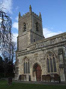
St Edburg's Church in Bicester was founded as a minster perhaps in the mid 7th century after St Birinus converted Cynegils King of the West Saxons after their meeting near Blewbury. The site was just east of the old Roman road between Dorchester and Towcester that passed through the former Roman town at Alchester. The earliest church was probably a timber structure serving the inhabitants of the growing Saxon settlements on each side of the River Bure, and as a mission centre for the surrounding countryside. Archaeological excavations at Procter's Yard identified the ecclesiastical enclosure boundary, and a large cemetery of Saxon graves suggesting a much larger churchyard has been excavated on the site of the Catholic Church car park almost opposite St Edburg's.
The first documentary reference is the Domesday Book of 1086 which records it as Berencestra, its two manors of Bicester and Wretchwick being held by Robert D'Oyly who built Oxford Castle. The town became established as twin settlements on opposite banks of the River Bure, a tributary of the Ray, Cherwell and ultimately the River Thames.
By the end of the 13th century Bicester was the centre of a deanery of 33 churches. It is unclear when St Edburg's Church was rebuilt in stone, but the 12th century church seems to have had an aisleless cruciform plan. Earliest surviving material includes parts of the nave north wall including parts of an originally external zigzag string course, the north and south transepts and the external clasping buttresses of the chancel. The triangular-headed opening at the end of the north wall of the nave was probably an external door of the early church. Three great round-headed Norman arches at the end of the nave mark the position of a 13th-century tower.
The Augustinian Priory was founded by Gilbert Bassett around 1183 and endowed with land and buildings around the town and in other parishes including 180 acres (73 ha) and the quarry at Kirtlington, 300 acres (120 ha) at Wretchwick (now called), 135 acres (55 ha) at Stratton Audley, and on Gravenhill and Arncott. It also held the mill at Clifton and had farms let to tenants at Deddington, Grimsbury, Waddesdon and Fringford. Although these holdings were extensive and close to the market at Bicester, they appear to have been poorly managed and did not produce much income for the priory.
The priory appropriated the church in the early 13th century. The church was enlarged by a south aisle, and arches were formed in the nave and south transept walls linking the new aisle to the main body of the church.
A further extension was made in the 14th century when the north aisle was built. The arched openings in the north wall of the nave are supported on thick octagonal columns. The Perpendicular Gothic north chapel (now vestry) is of a similar date, on the east wall are two windows. The chapel originally had an upper chamber used later for the vicars' grammar school, accessed from an external staircase which forms part of the north eastern buttress.
In the 15th century the upper walls of the nave were raised to form a clerestory with square-headed Perpendicular Gothic windows. The earlier central tower and its nave arch was taken down and the nave roof rebuilt (the present roof is a copy of 1803). The columns of the north arcade were undercut making them appear very slim and the capitals top heavy. In the east bay of the nave, there is carved decoration probably forming part of a canopied tomb originally set between the columns. The west tower was built in three stages, each stage marked by a horizontal string course running round the outside. The construction would have taken several years to complete. The battlements and crockets on the top of the tower were replaced in the mid 19th century.
The priory church was built around 1200, and enlarged around 1300 in association with the construction of the Purbeck marble tomb of St Eadburh. This may have been the gift of the priory's patron Henry de Lacy, 3rd Earl of Lincoln. The walled rectangular enclosure of the priory lay just south of the church. The gatehouse was on the site of 'Chapter and Verse' Guesthouse in Church Lane. The library, dovecote and houses in Old Place Yard lie within the central precinct. St Edburg's House is built partly over the site of the large priory church. This was linked by a cloister to a quadrangle containing the refectory, kitchens, dormitory and prior's lodging. The priory farm buildings lay in the area of the present church hall, and these had direct access along Piggy Lane to land in what is now the King's End estate.
Early charters promoted Bicester's development as a trading centre, with a market and fair established by the mid 13th century. By this time two further manors are mentioned, Bury End and Nuns Place, later known as Market End and King's End respectively.
Later history
The Lord of the Manor of Market End was the Earl of Derby who in 1597 sold a 9,999-year lease to 31 principal tenants. This in effect gave the manorial rights to the leaseholders, 'purchased for the benefit of those inhabitants or others who might hereafter obtain parts of the demesne'. The leaseholders elected a bailiff to receive the profits from the bailiwick, mainly from the administration of the market and distribute them to the shareholders. From the bailiff's title the arrangement became known as the Bailiwick of Bicester Market End. By 1752 all of the original leases were in the hands of ten men, who leased the bailiwick control of the market to two local tradesmen.
A fire in 1724 had destroyed the buildings on the eastern side of Water Lane. A Nonconformist congregation was able to acquire a site that had formerly been the tail of a long plot occupied at the other end by the King's Arms. Their chapel built in 1728 was 'surrounded by a burying ground and ornamented with trees. At the southern and downstream end of Water Lane, there were problems of pollution from animal dung from livery stables on the edge of town associated with the London traffic.
Edward Hemins was running a bell-foundry in Bicester by 1728 and remained in business until at least 1743.[7] At least 19 of his church bells are known to survive,[7] including some of those in the parishes of Ambrosden, Bletchingdon, Piddington and Wootton in Oxfordshire and Culworth in Northamptonshire.
King's End had a substantially lower population and none of the commercial bustle found on the other side of the Bure. The manorial lords, the Cokers, lived in the manor house from 1584. The house had been rebuilt in the early 18th century remodelled in the 1780s. The park was enlarged surrounded by a wall after 1753 when a range of buildings on the north side of King's End Green were demolished by Coker. A westward enlargement of the park also extinguished the road that followed the line of the Roman road. This partly overlapped a pre-1753 close belonging to Coker. The effect of the enlargement of the park was to divert traffic at the Fox Inn through King's End, across the causeway to Market Square and Sheep Street before returning to the Roman road north of Crockwell.
The two townships of King's End and Market End evolved distinct spatial characteristics. Inns, shops and high status houses clustered around the triangular market place as commercial activity was increasingly concentrated in Market End. The bailiwick lessees promoted a much less regulated market than that found in boroughs elsewhere. Away from the market, Sheep Street was considered 'very respectable' but its northern end at Crockwell was inhabited by the poorest inhabitants in low quality, subdivided and overcrowded buildings.
By 1800, the causeway had dense development forming continuous frontages on both sides. The partially buried watercourses provided a convenient drainage opportunity, and many houses had privies discharging directly into the channels. Downstream, the Bure ran parallel with Water Lane, then the main road out of town towards London. Terraces of cottages were built backing onto the brook, and here too these took advantage of the brook for sewage disposal, with privies cantilevered out from houses over the watercourse. Town houses took their water from wells dug into the substrate which became increasingly polluted by leaching of waste through the alluvial bed of the Bure.
Until the early 19th century the road from the market place to King's End ran through a ford of the Bure brook and on to the narrow embanked road across the boggy valley. The causeway became the focus for development from the late 18th century as rubbish and debris was dumped on each side of the road to form building platforms, minor channels of the braided stream were encased and culverted as construction proceeded.
Architecture
The vernacular buildings of the town have features of both the Cotswold dip slope to the northwest and the Thames Valley to the southeast. The earliest surviving buildings of the town are the medieval church of St Edburg; the vicarage of 1500 and two post Dissolution houses in the former Priory Precinct constructed from reused mediaeval material. These buildings are mainly grey oolitic limestone, from the Priory Quarry at Kirtlington, five miles (8 km) west on Akeman Street, some ginger lias (ironstone) comes from the area around Banbury and white and bluish grey cornbrash limestone was quarried in Crockwell and at Caversfield two miles (3 km) to the north.
Early secular buildings were box framed structures, using timber from the Bernwood Forest. Infilling of frames was of stud and lath with lime render and limewash. Others were of brick or local rubble stonework. The river valleys to the south and east of the town were the source of clay for widespread local production of brick and tile. In the 18th and 19th centuries the Page-Turners had a brick fields in Wretchwick and Blackthorn and which operated alongside smaller produces such as the farmer George Coppock who produced bricks as a sideline.
Local roofing materials included longstraw thatch, which persisted on older and lower status areas on houses and terraced cottages. Thatch had to be laid at pitches in excess of 50 degrees. This generated narrow and steep gables which also suited heavy limestone roofs made with Stonesfield slate or other roofing slabs from the Cotswolds. The other widespread roofing material was local red clay plain tiles. 19th century bulk transport innovations associated with canal and railway infrastructure allowed imports of blue slate from North Wales. These could be laid at much more shallow pitches on fashionable high status houses.
Apart from imported slate, a striking characteristic of all of the new buildings of the early 19th century is the continued use of local vernacular materials, albeit in buildings of non-vernacular design. The new buildings were constructed alongside older wholly vernacular survivals and, sometimes superficially updated with fashionable applied facades, fenestration or upper floors and roofs.
Modern Bicester
Military links
The town has a long-standing connection with the military. Ward Lock & Co's 'Guide to Oxford and District' suggests that Alchester was 'a kind of Roman Aldershot'. During the Civil War (1642–49) Bicester was used as the headquarters of parliamentary forces. Following the outbreak of the French Revolutionary Wars from 1793, John Coker, the manorial lord of Bicester King's End, formed an 'Association for the Protection of Property against Levellers and Jacobins' as an anti-Painite loyalist band providing local militia and volunteer drafts for the army. When Oxford University formed a regiment in 1798, John Coker was elected Colonel.
Coker's Bicester militia had sixty privates, and six commissioned and non-commissioned officers led by Captain Henry Walford. The militia briefly stood down in 1801 after the Treaty of Amiens. But when hostilities resumed after 1804 invasion anxiety was so great as to warrant the reformation of the local militia as the Bicester Independent Company of Infantry. It had double the earlier numbers to provide defence in the event of an invasion or Jacobin insurrection. The Bicester Company was commanded by a captain, with 2 lieutenants, an ensign, 6 sergeants, 6 corporals and 120 privates. Their training and drill were such that they were deemed 'fit to join troops in the line'. The only action recorded for them is in 1806 at the 21st birthday celebrations of Sir Gregory O Page-Turner when they performed a feu de joie 'and were afterwards regaled at one of the principal inns of the town'.
During the First World War an airfield was established north of the town for the Royal Flying Corps. This became a Royal Air Force station, but is now Bicester Airfield, the home of Windrushers Gliding Club, which was absorbed into the military gliding club previous based there, to re-emerge in 2004 when the military club left the airfield. There is now a campaign by the BCH to turn the RAF centre into a museum. They say that it is 'the best example of a historic RAF site in the UK.
The MoD's largest ordnance depot at MoD Bicester is just outside the town. The depot has its own internal railway system, the Bicester Military Railway.
Transport
Road
The town's nearest motorway is the M40 which has two junctions serving Bicester; junction 9 to the south which is an interchange for the A34 towards Oxford and A41 for Bicester and Aylesbury and junction 10 near Ardley to the north with the A43 towards Brackley.
Bicester has a ring road which is made up of the A41, A4095, A4421 and the newly completed Vendee Drive which forms part of the B4030.
Rail
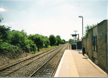
Bicester benefited from the Railway Mania of the 1840s. The Buckinghamshire Railway completed the railway between Bletchley and Oxford in 1851, opening "a neat station at the bottom of the London road" in 1850 to serve Bicester. The town's first fatal railway accident occurred at this station in September.[9] In 1910 the Great Western Railway built the Bicester cut-off line through Bicester to complete a new fast route between London and Birmingham, and opened a large railway station on Buckingham Road to serve Bicester. The GWR station is Bicester North, and to avoid confusion the Buckinghamshire Railway station was renamed Bicester Town. Bicester Town was controversially renamed Bicester Village when reopened after rebuilding in October 2015.
Bicester Town railway station was closed in 1968 but reopened in 1987 for shuttle services to Oxford, although these do not continue towards Bletchley. In 2011 funding for the East-West Rail Link was agreed: this link is planned to restore passenger services between Oxford and Bletchley via Bicester in 2017, then continuing to Milton Keynes, Bedford with plans to extend the route as far as Ipswich and Norwich.
Bicester has also benefited from the Chiltern Evergreen 3 project which allows trains to run from London Marylebone to Oxford via Bicester's two railway stations. Bicester Town has been completely rebuilt and renamed contrary to local opinion Bicester Village, Bicester North has been refurbished and the journey between Bicester and Oxford will be 15 minutes on project completion in 2016, half the current journey time.
Chiltern Railways trains between Marylebone and Birmingham Snow Hill call at Bicester North.
Bus
Bicester also has local bus services to Oxford and Banbury, and is served by long-distance route X5 between Oxford and Cambridge. Northampton once ran service 8 as far as Bicester, however this was renumbered to 88 in 2016 and only ran as far as Silverstone, with one off-peak journey numbered X88 and now terminates at Brackley Tesco.
Air
Bicester is within an hour's drive to three international airports and within 10 miles of the minor London Oxford Airport.
London Luton Airport is the nearest international airport 47 miles by road, taking around 1 hour 5 minutes. Due to the town's location beside the M40 motorway, it is a slightly shorter journey time of 51 minutes to Heathrow Airport which is 51 miles away and 54 minutes to Birmingham Airport which is 54 miles away.
Town Council
Bicester Town Council has its offices in the Garth in the picturesque and award winning Garth Park.
Residents associations
Bicester has several active residents' associations including: Bure Park Residents' Association; Langford Village Community Association; Priory Lane Residents' Association and Bicester Parkland View Residents' Association.
Radio Bicester
Radio Bicester is a community online radio station for Bicester, founded by Ross Arrowsmith and Steven Fulford after BRACE FM became a grounded attempt in summer 2012. Now, with a team including Sam Isaacs, Neil Cole, Jamie Gray, Naveena Gill, Thomas Bunting, and Daron Coaker, the station plays local music with a variety of entertainment shows broadcast from the Bicester Courtyard, curated by the youth supporting charity OYAP Trust. Radio Bicester continues to develop its schedule and give the public the chance to broadcast their own programmes. Radio Bicester's Website
Schools
Bicester has two secondary schools: The Bicester School and the Cooper School. There are a number of primary schools including: Langford Village Primary; Glory Farm Primary; Southwold; Brookside Primary School; St Edburg's; Five Acres; Longfields; St Mary's Primary School; King's Meadow and Bure Park Primary.
The new Kingsmere development (south of Bicester) is due to create a two-form primary school and a secondary school.
Sport and leisure
Bicester and North Oxford Cricket Club play at Akeman Street Chesterton. It was formed in 1996 from a merger of Bicester Town, (founded in 1871) and the North Oxford Cricket Clubs which until 1929 shared the Oxford Road ground with the town's football club. As of 2014 season the senior teams play in the Cherwell League.[10] Bicester Rugby Club was founded in 1947 originally playing on land provided by the King's Head pub. The club is presently based at the Akerman Street Ground. The senior teams play in the Berks/Bucks & Oxon Premier[11]
Bicester Town Football Club was founded in 1896 and until the 2010–11 season played in the Hellenic League. Bicester Colts F.C. organises teams from ages 5 through to 17 at facilities based at Akerman Street, Chesterton.[12]
Bicester Blue Fins Amateur Swimming Club was established in 1950 and has been based at Bicester Leisure Centre since 1971. Bicester Blue Fins is 'SWIM 21' accredited and affiliated to the Oxfordshire & North Buckinghamshire ASA and the ASA South East Region.[13]
The Bicester Leisure Centre which opened in 1970 comprises swimming pool, fitness, gym facilities and all-weather pitches. Other popular sports and pastimes include tennis is played at the Bicester Tennis Club based at the Garth. It is affiliated to the Oxfordshire and Thames Valleys LTAs.[14] Lawn bowls is organised by the Bicester Bowls Club which was founded in 1862 and since 1951 has been at the Garth.[15] There are two 18-hole golf courses at the Bicester Hotel and Bicester Country Club. The traditional game, popular in Oxfordshire of Aunt Sally is popular in the town and is organised under the auspices of the Bicester and District Aunt Sally League.[16]
Shopping
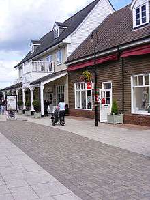
The historic shopping streets, particularly Sheep Street and Market Square, have a range of local and national shops together with cafés, pubs and restaurants. Sheep Street is now pedestrianised, with car parks nearby. There are weekly markets on Fridays in the town centre along with farmers' markets and an occasional French market.
A £70 million redevelopment of the town centre, originally planned to start in 2008, was delayed by the onset of the credit crunch; Sainsbury's pledged to develop the project itself in January 2009.[17] The development, since named Pioneer Square, is now complete and opened on 9 July 2013, offering a Sainsbury's supermarket, 7 screen Vue Cinemas and many smaller retail units and restaurants such as Nando's and Prezzo. There are further plans to construct a new civic centre adjacent to the new buildings, as well as talk of improving the Market Square at a later date.
South of Bicester, beyond Pingle Field, is designer outlet centre Bicester Village Shopping Centre, and beyond that is Bicester Avenue Home & Garden Centre, one of the largest garden centres in the UK.
Churches
Most churches in Bicester belong to the ecumenical organisation Churches Together in Bicester: Crowded House (Pioneers in missional Community, meeting in the Moto); St Edburg's Parish Church (Church of England); Emmanuel Church (Church of England, meeting in their new (December 2012) church at Barberry Place); Bicester Community Church (meeting in the Salvation Army Hall); Bicester Methodist Church; The Church of the Immaculate Conception (Roman Catholic); Elim Lighthouse Church (Pentecostal – meeting in Bicester Methodist Church); Orchard Baptist Church (meeting in Cooper School); and the Salvation Army.
Churches independent of Churches Together are: Bicester Baptist Church (meeting in Southwold Community Centre); and Hebron Gospel Hall.
Future development
Bicester is in the midst of several construction projects the most recent of these completed being the new Tesco superstore[18] which replaces the former site in Pingle Drive. The 5,181 sq metre Pingle Drive site shall be used to expand the Bicester village outlet centre by an additional quarter in size.[19]
On 1 December 2014, it was announced that Bicester had been chosen as the site for the British government's second new garden city. Up to 13,000 new homes could be built in the town, as part of plans to help deal with the UK's housing shortage. The town is expected to get a new railway station to serve the expanded population as part of rail plans previously detailed by Deputy Prime Minister Nick Clegg.[20]
Since the garden city announcement, work has began on the 6,000 home Eco-Town development[21] to the northwest of Bicester and 1,585 home south-westerly development named Kingsmere.[22] The first residents moved into the Eco-Town development in May 2016,[23] in the newly named Elmsbrook area.
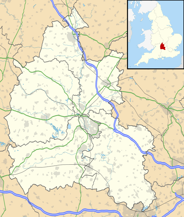
Geography
Bicester is in north Oxfordshire 12 miles north of Oxford, near the Buckinghamshire and Northamptonshire borders.
 |
Banbury, Royal Leamington Spa | Brackley, Northampton | Buckingham, Milton Keynes, Bletchley | |
| Chipping Norton, Cheltenham | |
Aylesbury, Leighton Buzzard | ||
| ||||
| | ||||
| Woodstock | Kidlington, Oxford | Thame |
Areas and suburbs
There are 5 electoral wards, North, East, South, West and Town as defined by the town council. The areas of Bicester include:
- Highfield
- Woodfield
- King's End
- Bure Park
- Glory Farm
- Southwold
- Langford Village
- Kingsmere (New housing development)
- Elmsbrook (new housing development, eco-town)
Climate
Bicester experiences an oceanic climate (Köppen climate classification Cfb) similar to almost all of the United Kingdom.
| Climate data for Bicester | |||||||||||||
|---|---|---|---|---|---|---|---|---|---|---|---|---|---|
| Month | Jan | Feb | Mar | Apr | May | Jun | Jul | Aug | Sep | Oct | Nov | Dec | Year |
| Average high °C (°F) | 7 (45) |
7 (45) |
10 (50) |
13 (55) |
16 (61) |
20 (68) |
22 (72) |
21 (70) |
18 (64) |
14 (57) |
10 (50) |
7 (45) |
13 (55) |
| Average low °C (°F) | 1 (34) |
1 (34) |
3 (37) |
4 (39) |
7 (45) |
10 (50) |
12 (54) |
12 (54) |
10 (50) |
7 (45) |
4 (39) |
2 (36) |
6.1 (43.1) |
| Average rainfall mm (inches) | 56.1 (2.209) |
39.4 (1.551) |
49.6 (1.953) |
42.3 (1.665) |
59.0 (2.323) |
45.1 (1.776) |
52.3 (2.059) |
57.7 (2.272) |
52.1 (2.051) |
62.5 (2.461) |
65.3 (2.571) |
62.5 (2.461) |
643.9 (25.352) |
| Average snowy days | 5 | 5 | 3 | 1 | 0 | 0 | 0 | 0 | 0 | 0 | 0 | 2 | 16 |
| Source: [24] | |||||||||||||
Notable residents and natives
- Albert Freeman Africanus King, (born in a hospital) doctor who took care of Abraham Lincoln when he was shot
- Ebenezer Beasley, director of the Mormon Tabernacle Choir 1880–89
- John Dunkin (1782–1846) topographer and local historian, who wrote comprehensive history of Bicester and the surrounding villages – The History and Antiquities of Bicester and The History and Antiquities of the Hundreds of Bullingdon and Ploughley
- Tim Harvey, racing driver and TV-commentator.
References
- Notes
- ↑ United Kingdom Censuses 1951–2001
- ↑ Bicester Garden City BBC News.
- ↑ Dunkin 1816
- ↑ Page 1907, pp. 93–95.
- ↑ Parkinson 2007, p. 6.
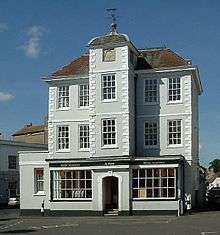
- ↑ Historic England. "47, Market Square (Grade II) (1046458)". National Heritage List for England. Retrieved 11 January 2015.
- 1 2 Dovemaster (25 June 2010). "Bell Founders". Dove's Guide for Church Bell Ringers. Retrieved 10 July 2011.
- ↑ "Last train to run on Oxford to Bicester line before revamp". BBC News. 14 February 2014.
- ↑ Blomfield 1882–94
- ↑ Bicester and North Oxford CC website, Accessed 5 September 2014
- ↑ Bicester Rugby Club website, Accessed 5 September 2014
- ↑ Bicester Colts F.C. website, Accessed 5 September 2014
- ↑ Bicester Blue Fins Amateur Swimming Club website, Accessed 5 September 2014
- ↑ Biceter Tennis Club website, Accessed 5 September 2014
- ↑ Bicester Bowls Club website, Accessed 5 September 2014
- ↑ icester and District Aunt Sally League website, Accessed 5 September 2014
- ↑ "New Year brings good news for Bicester town centre". Cherwell District Council. 24 February 2010.
- ↑ "Loyal Tesco customers queue at 8am to be the first inside new Bicester superstore". Retrieved 19 June 2016.
- ↑ "Bicester Village to expand by a quarter". Retrieved 19 June 2016.
- ↑ "Bicester chosen as new garden city with 13,000 homes". BBC News. 1 December 2014. Retrieved 2 December 2014.
- ↑ Eco-Town Development.
- ↑ Kingsmere.
- ↑ "First residents move into Bicester's 'eco-homes'". Retrieved 19 June 2016.
- ↑ "Averages for Bicester".
- Sources and further reading
- Beesley, Alfred (1841). The History of Banbury. 16 OxLSC (Extra illustrated ed.).
- Blomfield, J.C. (1882–94). History of the present deanery of Bicester, Part 2. Oxford.
- Bond, C.J. (1980). "The Small Towns of Oxfordshire in the Nineteenth Century". In Rowley, T. The Oxford Region. pp. 55–79.
- Dannatt, G.H. (1961–62). "Bicester in the Seventeenth and Eighteenth Centuries". Oxoniensia. Oxford: Oxfordshire Architectural and Historical Society. XXVI–XXVII: 244–311.
- Dunkin, John (1816). The History and Antiquities of Bicester; a market town in Oxfordshire.
- Dunkin, John (1823). History and Antiquities of the hundreds of Bullingdon and Ploughley.
- Kennett, White (1818) [circa 1718]. Parochial Antiquities Attempted in the History of Ambrosden, Burchester, and other adjacent parts in the counties of Oxford and Bucks. 1 (expanded ed.). Oxford: Clarendon Press. pp. xvii, 582.
- Kennett, White (1818) [circa 1718]. Parochial Antiquities Attempted in the History of Ambrosden, Burchester, and other adjacent parts in the counties of Oxford and Bucks. 2 (expanded ed.). Oxford: Clarendon Press. pp. 526, un–numbered indices of names and places, extensive glossary.
- Lawton, E.R.; Sackett, M.W. (1992). The Bicester Military Railway. Oxford Publishing Co. ISBN 0-86093-467-5.
- Lobel, Mary D., ed. (1959). Victoria County History: A History of the County of Oxford: Volume 6. pp. 14–56.
- Martin, Jon (2011). "Prehistoric, Romano-British and Anglo-Saxon Activity at Whitelands Farm, Bicester". Oxoniensia. Oxfordshire Architectural and Historical Society. LXXVI: 173–240. ISSN 0308-5562.
- Mitchell, V.; Smith, K. (2005). Oxford to Bletchley. Country Railway Routes. Middleton Press. ISBN 1-904474-57-8.
- Page, W.H., ed. (1907). A History of the County of Oxford. Victoria County History. 2: Ecclesiastical History, etc. Westminster: Archibald Constable & Co. pp. 93–95, 154.
- Parkinson, R. (2007). Continuity and Change in an Oxfordshire Market Town – Bicester 1801–1861. Oxford: unpublished dissertation, Kellogg College, Oxford.
- Sherwood, Jennifer; Pevsner, Nikolaus (1974). Oxfordshire. The Buildings of England. Harmondsworth: Penguin Books. pp. 452–456. ISBN 0-14-071045-0.
- A Pictorial and Descriptive Guide to Oxford and District. London: Ward Lock & Co. 1928.
External links
| Wikivoyage has a travel guide for Bicester. |
| Wikimedia Commons has media related to Bicester. |

Oxfordshire Portal | |
| Boroughs or districts | |
| Major settlements | |
| Topics | |