Black Fork (Cheat River)
| Black Fork | |
| River | |
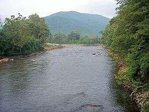 The Black Fork at Hendricks, West Virginia looking upstream. The confluence of the Blackwater River (left) and the Dry Fork (right) is visible. | |
| Country | United States |
|---|---|
| State | West Virginia |
| County | Tucker |
| Source | Dry Fork |
| - location | Col between Harper and Yokum knobs, Randolph County, West Virginia |
| - elevation | 3,740 ft (1,140 m) |
| - coordinates | 38°44′01″N 79°38′52″W / 38.73361°N 79.64778°W |
| Secondary source | Blackwater River |
| - location | Canaan Valley, Tucker County, West Virginia |
| - elevation | 3,540 ft (1,079 m) |
| - coordinates | 39°03′32″N 79°29′04″W / 39.05889°N 79.48444°W |
| Source confluence | |
| - location | Hendricks, West Virginia |
| - elevation | 1,700 ft (518 m) |
| - coordinates | 39°04′20″N 79°37′45″W / 39.07222°N 79.62917°W [1] |
| Mouth | Cheat River |
| - location | Parsons, West Virginia |
| - elevation | 1,621 ft (494 m) |
| - coordinates | 39°06′39″N 79°40′44″W / 39.11083°N 79.67889°WCoordinates: 39°06′39″N 79°40′44″W / 39.11083°N 79.67889°W |
| Length | 4 mi (6 km) [2] |
| Basin | 500 sq mi (1,295 km2) [3] |
 Map of the Monongahela River basin, with Black Fork highlighted.
| |
The Black Fork is a principal tributary of the Cheat River in the Allegheny Mountains of eastern West Virginia, USA. It is a short stream, about four miles (6 km) in length,[4] formed by the confluence of two other streams not far above its mouth.[5] It was traditionally considered one of the five Forks of Cheat.
Geography
Via the Cheat, Monongahela and Ohio Rivers, it is part of the watershed of the Mississippi River, draining an area of 500 square miles (1,295 km²).[3] The Black Fork flows for its entire length in Tucker County. It is formed at the town of Hendricks by the confluence of the Dry Fork and the Blackwater River, and flows generally northwestwardly through Hambleton to Parsons, where it joins the Shavers Fork to form the Cheat River.[5]
Name
The U.S. Board on Geographic Names settled on "Black Fork" as the stream's name in 1930. According to the Geographic Names Information System, it has also been known historically as "Blackwater Fork" and as the Blackwater River.[1]

See also
References
- Julian, Norman. 2006. "Cheat River." The West Virginia Encyclopedia. Ken Sullivan, editor. Charleston, WV: West Virginia Humanities Council. ISBN 0-9778498-0-5.
- 1 2 U.S. Geological Survey Geographic Names Information System: Black Fork
- ↑ The American Rivers Outstanding Rivers List, Second Edition, May 1991. Compiled and edited by Matthew H. Huntington and John D. Echeverria. Washington, DC: American Rivers, Inc.
- 1 2 West Virginia Department of Environmental Protection. Watershed Atlas Project: Cheat River watershed Archived October 4, 2006, at the Wayback Machine.. Sum of watershed areas of Dry Fork, Blackwater River, Glady Fork, Laurel Fork, Gandy Creek, and Red Creek. Retrieved on December 11, 2006.
- ↑ The American Rivers Outstanding Rivers List, Second Edition, May 1991. Compiled and edited by Matthew H. Huntington and John D. Echeverria. Washington, DC: American Rivers, Inc.
- 1 2 DeLorme (1997). West Virginia Atlas & Gazetteer. Yarmouth, Maine: DeLorme. ISBN 0-89933-246-3.