Seneca Rocks
| Seneca Rocks | |
|---|---|
|
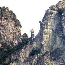
The North and South Peaks viewed from the front | |
 | |
| Location | Pendleton County, West Virginia |
| Nearest city | Seneca Rocks, West Virginia |
| Range | Appalachians |
| Coordinates | 38°50′05″N 79°21′58″W / 38.83472°N 79.36611°WCoordinates: 38°50′05″N 79°21′58″W / 38.83472°N 79.36611°W |
| Climbing type | traditional crag |
| Height | 900 above stream level [1] |
| Pitches | 4 |
| Ratings | 5.0-5.13 with most routes in 5.7-5.11 range |
| Grades | I and II |
| Rock type | Tuscarora quartzite |
| Quantity of rock | months worth (over 375 routes) |
| Development | well developed |
| Cliff aspect | east and west |
| Season | spring to fall |
| Ownership | National Forest |
| Camping | Seneca Shadows[2] & 2 private campsites in town (all paid) |
| Classic climbs |
Gunsight to South Peak (5.3), |
| Stars |
|


Seneca Rocks is a large crag and local landmark in Pendleton County in the Eastern Panhandle of West Virginia, USA. It is the only "true peak" — a peak inaccessible except by technical rock climbing techniques — on the East Coast of the United States. One of the best-known scenic attractions in West Virginia, the sheer rock faces are a popular challenge for rock climbers.
Seneca Rocks is easily visible and accessible along West Virginia Route 28 near U.S. Route 33 in the Spruce Knob-Seneca Rocks National Recreation Area of the Monongahela National Forest.
Description
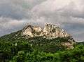
Seneca Rocks is at the north end of the River Knobs, which contain several other similar "razorback" ridges or "fins" such as Judy Rocks and Nelson Rocks, all on the western flank of North Fork Mountain. Seneca Rocks is a prominent and visually striking formation rising nearly 900 feet above the confluence of Seneca Creek with the North Fork of the South Branch of the Potomac River. It overlooks the community of Seneca Rocks, formerly known as "Mouth of Seneca". The Rocks consist of a North and a South Peak, with a central notch between. Formerly, a prominent pinnacle — "the Gendarme" — occupied the notch.
Geology
Seneca Rocks and nearby Champe Rocks are the most imposing examples in eastern West Virginia of several formations of the white/gray Tuscarora quartzite. The quartzite is approximately 250 feet thick here, located primarily on exposed ridges as caprock or exposed crags. The rock is composed of fine grains of sand that were laid down in the Silurian Period approximately 440 million years ago, in an extensive sand shoal at the edge of the ancient Iapetus Ocean. Eons of geologic activity followed, as the ocean slowly closed and the underlying rock uplifted and folded. Millions of years of erosion stripped away the overlying rock and left remnants of the arching folds in outcrops such as Seneca Rocks.
History

Evidence suggests that the Native Americans of the Archaic Period may have camped frequently at the mouth of nearby Seneca Creek at the foot of the Rocks. The famous Great Indian Warpath, known locally as the "Seneca Trail", followed the Potomac River, allowing the Algonquian, Tuscarora, and Seneca nations to transit the area for purposes of trade and war. Excavation for the building of the present Seneca Rocks Visitor Center uncovered evidence of two villages,[3] the more recent of which thrived about 600 years ago. About a dozen dwellings were found.
The first European visitors to see the region were surveyors who passed through around 1746, and the first settlers arrived at Mouth of Seneca fifteen years later. At that time, West Virginia (or western Virginia as it was then) was the edge of the great wilderness. The Rocks were visited and sketched by the well-known writer and magazine illustrator David Hunter Strother (known by his pseudonym "Porte Crayon") around 1853. His sketches were reworked and published two decades later as a popular wood engraving in an 1872 issue of Harpers New Monthly Magazine.
It is unknown who the first person was to climb Seneca Rocks. Undoubtedly Native Americans scaled the rocks prior to European settlers reaching the area, but there is no record of their ascents. The historic ascent of Paul Bradt, Don Hubbard, and Sam Moore in 1939 found an inscription of "D.B. September 16, 1908." This has been attributed to a surveyor named Bittenger who was known to be working in the area.[4]
The documented climbing history of the Rocks begins in 1935 with a roped descent - the ascent was a steep hike – of the North Peak by Paul Bradt and Florence Perry.[4] In the 1930s and 40's only a few climbers, mostly from the Washington, D.C., and Pittsburgh areas, attempted to climb Seneca Rocks.
In 1943 and '44, as part of the West Virginia Maneuver Area, 10th Mountain Division[5] of the U.S. Army used Seneca, Nelson and Champe Rocks to train mountain troops in assault climbing in preparation for action in the Apennines of Italy. They left behind an estimated 75 thousands soft iron pitons, some of which can still be found on the rocks,[5] and which inspired one of the faces to be named "The Face of a Thousand Pitons".
The Spruce Knob-Seneca Rocks National Recreation Area (NRA) was established within the Monongahela National Forest by an act of the U.S. Congress on September 28, 1965. The Rocks themselves were purchased by the federal government in 1969 from the heirs of D. C. Harper.
The original visitor center was opened in 1978, constructed on a grant of $297,000.[6] A 1985 flood severely damaged the facility. On October 22, 1987, "the Gendarme", an isolated and prominent pinnacle of the Rocks, fell to the ground.[7][8] On May 26, 1992, the visitor center was destroyed by arson.[9][10] The current visitor center — known as the Seneca Rocks Discovery Center — was completed in the fall of 1998 on a 5 million dollar grant.[11]
The "Seneca Rock" turnpoint at 38°50′03″N 79°22′04″W / 38.83417°N 79.36778°W has been used by glider pilots for gliding competitions and soaring awards because its distinctive appearance in aerial photographs made it suitable for photo documentation of the flight performance.[12] This turnpoint was used on many 500 kilometer out-and-return course flights from Ridge Soaring Gliderport in Julian, Pennsylvania, including an October 15, 1995, flight by Canadian pilot Walter Weir that was recognized as a world record at the time.[13]
Rock climbing
There are 375 major mapped climbing routes, varying in degree from 5.0 (the easiest) to 5.13 (the hardest). There are two climbing schools located in Seneca Rocks who train prospective climbers in beginning and advanced rock climbing: Seneca Rocks Climbing School and Seneca Rocks Mountain Guides.
Both the East and West faces of the North and South Peak offer single and multi-pitch routes up to 300 ft in length. Technical routes also exist on the Lower Slabs, located on the slopes below the west face of the North Peak, and on the Southern Pillar, directly across Roy Gap from the South Peak. Because of the way the rock was uplifted, there are many vertical cracks that offer excellent jamming and good protection. Routes range from 5.0-5.13, nearly all of which require the leader placing protection (traditional climbing). Some routes and their rating in the Yosemite Decimal System are represented in the picture on the right. The South Peak is the tallest peak east of Devils Tower in Wyoming that is only accessible by 5th class climbing.[14]
According to the warning sign near the top of North Peak, 15 people have died in falls while climbing Seneca Rocks since 1971.
Popular legends
A popular romance of the Rocks — "The Betrothal of Snow Bird, Princess of the Seneca Indians" — was written in 1932 by Harry Malcolm Wade.[15] West Virginia writer J. Lawrence Smith provides the following short summary of the story:
"Princess Snow Bird, who had grown to maidenhood in the shadow of the rocks and scaled their heights many times, proposed a contest to her father, [Chief] Bald Eagle. She would climb to the crest of the rocks as prospective suitors followed. The first to take her hand would become her mate. Bald Eagle agreed, and at the end of the climb, of seven suitors, only one remained, the others having turned back from fear or fallen to their deaths. From their lofty perch, Snow Bird and her future mate surveyed the surrounding realm of the Seneca that would be theirs to rule one day."[16]
In reality, the Seneca homeland was in what is now western New York state, and what Seneca tribesmen passed this way were strictly transients. (The historical "Chief Bald Eagle" [d. 1779], also known as Chief Woapalanne, was a Lenape leader of central Pennsylvania, not a Seneca of [West] Virginia.)
Gallery
 Seneca Rocks viewed from the parking lot
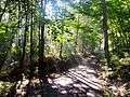 View of the trail / road (Roy Gap Road) to the South Peak area in the morning
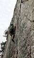 Climber on "Castor," east face of Seneca Rocks
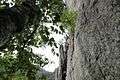 East face of Seneca Rocks
 Vertical panorama of "Triple S" on the west face of Seneca Rocks
 Seneca Rocks in the Fall
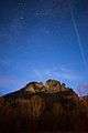 Seneca Rocks night sky, as seen from the town of Seneca Rocks, West Virginia in the Monongahela National Forest.
See also
References
Citations
- ↑ Forest Service. "Seneca Rocks". Retrieved 29 October 2012.
- ↑ Forest Service. "Seneca Shadows Campground". Retrieved 29 October 2012.
- ↑ Site No.: 46PD1, Site Name: Mouth of Seneca Site, Component Age: (blank) AD 810 AD 893, References: Robertson et al. in progress; also 46PD1, Mouth of Seneca Site, (blank), AD 960 AD 1025, Robertson et al. in progress. Source: Cultural Resource Analysts, Inc.
- 1 2 Barnes, Tony (2006). The Climber's Guide, 2nd Edit. Earthbound Sports, LLC. pp. 16–18.
- 1 2 Hörst, Eric J. (2001). Rock climbing Virginia, West Virginia, and Maryland (1st ed.). Guilford, Conn.: FalconGuides. ISBN 1560448121.
- ↑ "Grant County Press", 1970-7-1, Retrieved from Google news scan on 2009-1-10.
- ↑ RobSC "The Gendarme", summitpost.org, 2008-1-16. Retrieved on 2009-1-7.
- ↑ Baker, Donald P. "Famed W.Va. Rock Takes Tumble After 440 Million Years", The Washington Post, October 29, 1987. Retrieved on 2009-1-10.
- ↑ "The Glenville Democrat", 1992-6-11, Retrieved from Google news scan on 2009-1-10.
- ↑ "The Glenville Democrat", 1992-9-10, Retrieved from Google news scan on 2009-1-10.
- ↑ "Seneca Rocks New Discovery Center Opens", "wamonline.com", retrieved on 2009-1-10.
- ↑ Weir, Walter. "Ridge Soaring Gliderport - Photo Based (Julian, Pennsylvania)". Worldwide Soaring Turnpoint Exchange. Retrieved 2008-01-26.
- ↑ Wiese, Ursula (2007). The book of the best. Claresholm, AB, Canada: Soaring Association of Canada. Retrieved 2008-01-26.
- ↑ "Why Rock Climbing at Seneca Rocks West Virginia?". Seneca Rocks Climbing School.
- ↑ Wade, Harry Malcolm (July 1932). "The Betrothal of Snow Bird". West Virginia Review. IX: 418–. Retrieved 2012-04-16.
- ↑ Smith, J. Lawrence (November 2007). "Fact and the Fanciful: Native American History and Legends" (PDF). Wonderful West Virginia Magazine: 23–27. Retrieved 2012-04-16.
Other sources
- Tony Barnes (2006). Seneca Rocks: The Climber's Guide, 2nd edition. Earthbound Sports. ISBN 978-0-9643698-8-7.
External links
| Wikimedia Commons has media related to Seneca Rocks. |
- Monongahela National Forest (USDA Forest Service site website)
- "The Betrothal of Snow Bird, Princess of the Seneca Indians" at the MNF website