Williams River (West Virginia)
| Williams River | |
| River | |
 Williams River in the Monongahela National Forest. | |
| Country | United States |
|---|---|
| State | West Virginia |
| Counties | Pocahontas, Webster |
| Source | Beaverdam Run [1] |
| - location | Day Mountain, Pocahontas County, WV |
| - elevation | 3,892 ft (1,186 m) [2] |
| - coordinates | 38°14′47″N 80°09′54″W / 38.24639°N 80.16500°W |
| Secondary source | Downy Run [3] |
| - location | Day Mountain, Pocahontas County, WV |
| - elevation | 3,975 ft (1,212 m) [4] |
| - coordinates | 38°14′03″N 80°09′32″W / 38.23417°N 80.15889°W |
| Source confluence | [5] |
| - location | Pocahontas County, WV |
| - elevation | 3,448 ft (1,051 m) [1] |
| - coordinates | 38°13′43″N 80°01′10″W / 38.22861°N 80.01944°W |
| Mouth | Gauley River [5] |
| - location | Donaldson, WV |
| - elevation | 2,169 ft (661 m) |
| - coordinates | 38°23′06″N 80°30′48″W / 38.38500°N 80.51333°WCoordinates: 38°23′06″N 80°30′48″W / 38.38500°N 80.51333°W |
| Length | 33 mi (53 km) |
| Basin | 132 sq mi (342 km2) |
| Discharge | for Dyer, WV |
| - average | 30 cu ft/s (1 m3/s) [6] |
| - max | 1,840 cu ft/s (52 m3/s) (1971) |
| - min | 0.62 cu ft/s (0 m3/s) (1995) |
The Williams River is a tributary of the Gauley River, 33 miles (53 km) long,[7] in east-central West Virginia, USA. Via the Gauley, Kanawha and Ohio Rivers, it is part of the watershed of the Mississippi River, draining an area of 132 square miles (342 km²) in a sparsely populated region of the southern Allegheny Mountains and the unglaciated portion of the Allegheny Plateau.[7][8]
Name
The river has also been known historically as the South Fork of the Gauley River[5] In Webster County, it collects a short tributary known as the Middle Fork Williams River,[9] which itself collects the North Branch Middle Fork Williams River.[10] The river most likely was named after a landowner named Williams.[11]
Geography
The Williams River rises in southern Pocahontas County, approximately 5 miles (8 km) west of Marlinton, and flows initially northwardly, then westwardly into southern Webster County, where it joins the Gauley River approximately 2 miles (3 km) southeast of Cowen.[8] It flows for much of its length in the Monongahela National Forest, including the Cranberry Wilderness, in an area that was heavily logged in the early 20th century and has since been reforested. Coal mining activity took place along the river's lower course into the 1970s.[7]
Fishing
The Williams River is regarded as one of the five best trout fishing streams in West Virginia,[7] due to its cold water temperature, low turbidity, and frequent stockings of trout (amounting to 27,000 pounds annually) by the West Virginia Division of Natural Resources.[12]
 The Williams River as viewed from West Virginia Route 150 in Pocahontas County during a period of high water in 2006.
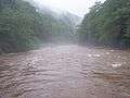 Fog on the Williams River during a period of high water in 2006.
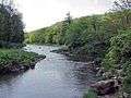 Williams River
See also
References
- 1 2 "Beaverdam Run". Geographic Names Information System. United States Geological Survey. 1980-06-27. Retrieved 2008-09-13.
- ↑ "USGS Elevation Web Service for -80.165, -38.246389". U.S. Geological Survey. Retrieved 2008-09-13.
- ↑ Hillsboro, West Virginia quadrangle (Map). 1:24,000. 7.5-Minute Series (Topographic). U.S. Geological Survey. 1995. ISBN 978-0-607-90769-8.
- ↑ "USGS Elevation Web Service for -80.1589, -38.23409". U.S. Geological Survey. Retrieved 2008-09-13.
- 1 2 3 "Williams River". Geographic Names Information System. United States Geological Survey. 1980-06-27. Retrieved 2008-09-13.
- ↑ "USGS Gage #03186500 on Williams River at Dyer, WV". National Water Information System. U.S. Geological Survey. Retrieved 2008-09-13.
- 1 2 3 4 McNeel, William P. "Williams River." The West Virginia Encyclopedia. Ken Sullivan, editor. Charleston, WV: West Virginia Humanities Council. 2006. ISBN 0-9778498-0-5.
- 1 2 DeLorme (1997). West Virginia Atlas & Gazetteer. Yarmouth, Maine: DeLorme. ISBN 0-89933-246-3.
- ↑ U.S. Geological Survey Geographic Names Information System: Middle Fork Williams River
- ↑ U.S. Geological Survey Geographic Names Information System: North Branch Middle Fork Williams River
- ↑ Kenny, Hamill (1945). West Virginia Place Names: Their Origin and Meaning, Including the Nomenclature of the Streams and Mountains. Piedmont, WV: The Place Name Press. p. 682.
- ↑ Monongahela National Forest: Williams River Retrieved on March 14, 2013.