Black Horse Pike
| Black Horse Pike | |
|---|---|
 | |
| Route information | |
| Maintained by NJDOT | |
| Length: | 52.04 mi[1][2][3][4] (83.75 km) |
| Component highways: |
|
| Major junctions | |
| West end: |
|
|
| |
| East end: |
|
| Highway system | |
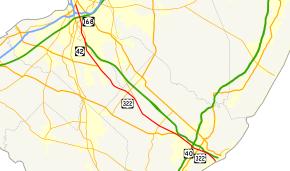
The Black Horse Pike is a designation used for a number of different roadways that had been part of a historic route connecting the Camden area to the area of Atlantic City, New Jersey. Roadways now bearing the Black Horse Pike designation include portions of New Jersey Route 168, New Jersey Route 42, U.S. Route 322 and U.S. Route 40.
Route description
Route 168
The Black Horse Pike heads south from U.S. Route 130 in Camden as a four-lane, divided highway comprising New Jersey Route 168, which continues north of US 130 on Mt. Ephraim Avenue. It heads south and interchanges New Jersey Route 76C, which heads west and provides access to Interstate 76 and the Walt Whitman Bridge. It passes through Haddon Township with many jughandles at intersections. It then passes through Mt. Ephraim, where the road was restriped in the late 1990s reducing it from 4 lanes to 2, and enters Bellmawr, where it interchanges with Exit 28 of Interstate 295 and Exit 3 of the New Jersey Turnpike.It then enters Runnemede, where it crosses New Jersey Route 41 and County Route 544. It then heads into Gloucester Township and interchanges with New Jersey Route 42. It continues south, passing through Blackwood, where it intersects County Route 534, and then widens back into a four-lane, divided highway. It then heads toward the southern terminus of the North–South Freeway (Route 42) and the western terminus of the Atlantic City Expressway, where Route 168 ends and the Black Horse Pike becomes Route 42.
Route 42

The Black Horse Pike heads south into Washington Township, Gloucester County on New Jersey Route 42 as a four-lane divided highway lined with many businesses. In Cross Keys, it intersects County Route 555. It then enters Monroe Township, where in Williamstown, it meets U.S. Route 322 and County Route 536 Spur. Here, Route 42 ends and US 322 heads east onto the Black Horse Pike.
US 322
US 322 heads southeast on the Black Horse Pike from Williamstown, intersecting County Route 536 and County Route 538. It heads into Folsom, Atlantic County, where it meets New Jersey Route 54 at a cloverleaf interchange and then the southern terminus of New Jersey Route 73 . It continues into Hamilton Township, passing through rural areas. It intersects County Route 559 shortly after crossing into Hamilton Township. Near Mays Landing, it features an interchange with New Jersey Route 50. It continues southeast and near the Hamilton Mall and the Atlantic City Race Track, it intersects U.S. Route 40.
US 40/US 322 concurrency
US 40 joins US 322 and the two routes continue to the southeast along the Black Horse Pike. Shortly after joining, the road intersects County Route 575, which then forms a concurrency on the Black Horse Pike along with US 40 and US 322. It heads into Egg Harbor Township, and Route 575 splits from the Black Horse Pike by heading south on English Creek Avenue. The Black Horse Pike has an intersection with County Route 563, which was formerly a traffic circle built in 1932 until it was replaced by traffic signals and jughandles in 2002.[5] The Black Horse Pike has a brief concurrency with 563 and then meets the Garden State Parkway, with access provided by way of Route 563 and County Route 608. The route continues east into Pleasantville, where it crosses U.S. Route 9. It then passes through the center of Pleasantville on Verona Avenue, with the name changing back to Black Horse Pike. At the border with Atlantic City, the road becomes Albany Avenue, which carries US 40 and US 322 into Atlantic City.
History
The origins of the Black Horse Pike can be traced to 1795 when Surveyors working for Old Gloucester County, laid out a new and straight road to replace the meandering Irish Road. The new roadway carried various names including the Newton Road, Chews Landing-Philadelphia Road, Mount Ephraim-Blackwoodtown Road, etc. State legislators in 1855 incorporated the Camden and Blackwoodtown Turnpike Company, converting the road into a toll road.
In 1923, the portion from Mays Landing to Atlantic City became part of Route 18S. With the 1927 New Jersey state highway renumbering, the route became New Jersey Route 42 from Camden to Mays Landing and New Jersey Route 48 from Mays Landing to Atlantic City. U.S. Route 322 was later designated along the road from Williamstown to Atlantic City and U.S. Route 40 from Mays Landing to Atlantic City.[6][7] With the 1953 New Jersey state highway renumbering, which eliminated long concurrencies between U.S. and state routes in New Jersey, the NJ 42 and NJ 48 designations were removed from the parts of the road already signed US 322 or US 40/US 322, with NJ 42 cut back to Williamstown and NJ 48 completely removed from the Black Horse Pike.[8] Following the completion of the North–South Freeway, NJ 42 was moved off the Black Horse Pike to the new freeway between Camden and Turnersville, and the New Jersey Route 168 designation was given to the Black Horse Pike between Camden and Turnersville.[9]
Major intersections
The mileposts correspond to the routes the Black Horse Pike follows.
| County | Location | mi[1][2][3][4] | km | Destinations | Notes |
|---|---|---|---|---|---|
| Camden | Camden | 9.72 | 15.64 | Western terminus of Black Horse Pike, west end of NJ 168 overlap | |
| Haddon Township | 9.48 | 15.26 | Interchange, access to and from southbound NJ 168 | ||
| Mount Ephraim | 8.07 | 12.99 | |||
| Bellmawr | 7.42 | 11.94 | I-295 exit 28 | ||
| 6.60 | 10.62 | NJTP exit 3 | |||
| Runnemede | 5.71 | 9.19 | |||
| 5.39 | 8.67 | ||||
| Gloucester Township | 3.42– 3.44 | 5.50– 5.54 | NJ 42 exits 9B-10A | ||
| 2.43 | 3.91 | ||||
| Gloucester | Washington Township | 0.00– 0.25 | 0.00– 0.40 | East end of NJ 168 overlap, west end of NJ 42 overlap, NJ 42 exit 7, ACE exit 44 | |
| 3.51 | 5.65 | ||||
| Monroe Township | 0.00 | 0.00 | East end of NJ 42 overlap, west end of US 322 overlap | ||
| 24.67 | 39.70 | ||||
| 30.13 | 48.49 | ||||
| Atlantic | Folsom | 34.66 | 55.78 | Interchange | |
| 36.90 | 59.38 | ||||
| Hamilton Township | 41.37 | 66.58 | Modified traffic circle | ||
| 46.03 | 74.08 | Interchange | |||
| 50.26 | 80.89 | West end of US 40 overlap | |||
| 50.46 | 81.21 | West end of CR 575 overlap | |||
| Egg Harbor Township | 52.38 | 84.30 | East end of CR 575 overlap | ||
| 55.47 | 89.27 | West end of CR 563 overlap | |||
| 55.87 | 89.91 | East end of CR 563 overlap | |||
| 55.95 | 90.04 | GSP exit 36 | |||
| Pleasantville | 57.62 | 92.73 | |||
| 57.99 | 93.33 | ||||
| Atlantic City | 60.17 | 96.83 | Eastern terminus of Black Horse Pike, east end of US 40/US 322 overlap | ||
| 1.000 mi = 1.609 km; 1.000 km = 0.621 mi | |||||
References
- 1 2 "Route 168 Straight Line Diagram" (PDF). New Jersey Department of Transportation. Retrieved March 19, 2007.
- 1 2 "Route 42 Straight Line Diagram" (PDF). New Jersey Department of Transportation. Retrieved March 27, 2007.
- 1 2 "US 322 Straight Line Diagram" (PDF). New Jersey Department of Transportation. Retrieved June 13, 2007.
- 1 2 "US 40 Straight Line Diagram" (PDF). New Jersey Department of Transportation. Retrieved October 14, 2009.
- ↑ Dwyer, Christopher. "Buchart-Horn Designs Replacement For Bygone Transportation System". Buchart Horn, Inc. & BASCO Associates. Archived from the original on August 13, 2007. Retrieved July 28, 2008.
- ↑ State of New Jersey, Laws of 1927, Chapter 319.
- ↑ Williams, Jimmy and Sharon. "1927 New Jersey Road Map". 1920s New Jersey Highways. Retrieved 2008-10-08.
- ↑ "1953 renumbering". New Jersey Department of Highways. Retrieved July 31, 2009.
- ↑ Map of New Jersey (Map). Cartography by H.M. Gousha. Chevron Oil Company. 1969.
See also
 U.S. Roads portal
 New Jersey portal
- White Horse Pike