Monroe Township, Gloucester County, New Jersey
- For the municipality of the same name in Middlesex County, see Monroe Township, Middlesex County, New Jersey.
| Monroe Township, New Jersey | |
|---|---|
| Township | |
| Township of Monroe | |
|
| |
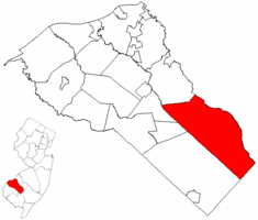 Monroe Township highlighted in Gloucester County. Inset map: Gloucester County highlighted in the State of New Jersey. | |
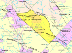 Census Bureau map of Monroe Township, Gloucester County, New Jersey | |
| Coordinates: 39°39′37″N 74°58′22″W / 39.660293°N 74.972747°WCoordinates: 39°39′37″N 74°58′22″W / 39.660293°N 74.972747°W[1][2] | |
| Country |
|
| State |
|
| County |
|
| Incorporated | March 3, 1859 |
| Named for | President James Monroe |
| Government[3] | |
| • Type | Faulkner Act (Mayor-Council) |
| • Body | Township Council |
| • Mayor | Daniel Teefy (D, term ends December 31, 2018)[4] |
| • Administrator | Kevin Heydel[5] |
| • Clerk | Susan McCormick[6] |
| Area[1] | |
| • Total | 46.926 sq mi (121.539 km2) |
| • Land | 46.393 sq mi (120.158 km2) |
| • Water | 0.533 sq mi (1.381 km2) 1.14% |
| Area rank |
36th of 566 in state 2nd of 24 in county[1] |
| Elevation[7] | 121 ft (37 m) |
| Population (2010 Census)[8][9][10] | |
| • Total | 36,129 |
| • Estimate (2015)[11] | 36,862 |
| • Rank |
63rd of 566 in state 2nd of 24 in county[12] |
| • Density | 778.8/sq mi (300.7/km2) |
| • Density rank |
408th of 566 in state 16th of 24 in county[12] |
| Time zone | Eastern (EST) (UTC-5) |
| • Summer (DST) | Eastern (EDT) (UTC-4) |
| ZIP code | 08094 - Williamstown[13] |
| Area code(s) | 609 and 856[14] |
| FIPS code | 3401547250[1][15][16] |
| GNIS feature ID | 0882137[1][17] |
| Website |
www |
Monroe Township is a township in Gloucester County, New Jersey, United States. As of the 2010 United States Census, the township's population was 36,129,[8][9][10] reflecting an increase of 7,162 (+24.7%) from the 28,967 counted in the 2000 Census, which had in turn increased by 2,264 (+8.5%) from the 26,703 counted in the 1990 Census.[18]
Monroe Township was originally formed as a township by an act of the New Jersey Legislature on March 3, 1859, from portions of Washington Township, while the area was still part of Camden County. Monroe Township was shifted to Gloucester County on February 28, 1871, along with the majority of Washington Township. In 1950, portions of the township were transferred to Winslow Township in Camden County.[19] The township was named for President James Monroe.[20]
Geography
According to the United States Census Bureau, the township had a total area of 46.926 square miles (121.539 km2), including 46.393 square miles (120.158 km2) of land and 0.533 square miles (1.381 km2) of water (1.14%).[1][2]
Victory Lakes (with a 2010 Census population of 2,111[21]) and Williamstown (15,567 residents as of 2010[22]) are unincorporated communities and census-designated places located within Monroe Township.[23]
Other unincorporated communities, localities and place names located partially or completely within the township include Berryland, Broad Lane, Cecil, Cross Keys, Downer, New Brooklyn and Radix.[24]
Demographics
| Historical population | |||
|---|---|---|---|
| Census | Pop. | %± | |
| 1860 | 1,417 | — | |
| 1870 | 1,663 | 17.4% | |
| 1880 | 1,858 | 11.7% | |
| 1890 | 1,945 | 4.7% | |
| 1900 | 2,402 | 23.5% | |
| 1910 | 3,015 | 25.5% | |
| 1920 | 3,292 | 9.2% | |
| 1930 | 4,064 | 23.5% | |
| 1940 | 4,310 | 6.1% | |
| 1950 | 5,531 | 28.3% | |
| 1960 | 9,396 | 69.9% | |
| 1970 | 14,071 | 49.8% | |
| 1980 | 21,639 | 53.8% | |
| 1990 | 26,703 | 23.4% | |
| 2000 | 28,967 | 8.5% | |
| 2010 | 36,129 | 24.7% | |
| Est. 2015 | 36,862 | [11][25] | 2.0% |
| Population sources: 1860-1870[26] 1880-2000[27] 1860-1920[28] 1860-1870[29] 1870[30] 1880-1890[31] 1890-1910[32] 1910-1930[33] 1930-1990[34] 2000[35][36] 2010[8][9][10] | |||
Census 2010
The 2010 United States Census counted 36,129 people, 12,815 households, and 9,445 families residing in the township. The population density was 778.8 per square mile (300.7/km2). The township contained 13,387 housing units at an average density of 288.6 per square mile (111.4/km2). The racial makeup of the township was 79.41% (28,689) White, 14.01% (5,060) Black or African American, 0.20% (73) Native American, 2.42% (875) Asian, 0.01% (5) Pacific Islander, 1.54% (557) from other races, and 2.41% (870) from two or more races. Hispanics or Latinos of any race were 4.97% (1,795) of the population.[8]
Out of a total of 12,815 households, 34.7% had children under the age of 18 living with them, 56.2% were married couples living together, 12.6% had a female householder with no husband present, and 26.3% were non-families. 21.5% of all households were made up of individuals, and 9.7% had someone living alone who was 65 years of age or older. The average household size was 2.80 and the average family size was 3.28.[8]
In the township, 25.7% of the population were under the age of 18, 7.9% from 18 to 24, 26.0% from 25 to 44, 26.8% from 45 to 64, and 13.6% who were 65 years of age or older. The median age was 38.9 years. For every 100 females the census counted 94.1 males, but for 100 females at least 18 years old, it was 90.0 males.[8]
The Census Bureau's 2006-2010 American Community Survey showed that (in 2010 inflation-adjusted dollars) median household income was $66,761 (with a margin of error of +/- $4,083) and the median family income was $83,929 (+/- $4,293). Males had a median income of $61,505 (+/- $3,058) versus $41,946 (+/- $1,826) for females. The per capita income for the borough was $28,270 (+/- $1,121). About 6.1% of families and 7.7% of the population were below the poverty line, including 8.3% of those under age 18 and 10.1% of those age 65 or over.[37]
Census 2000
As of the 2000 United States Census[15] there were 28,967 people, 10,521 households, and 7,848 families residing in the township. The population density was 622.3 people per square mile (240.3/km²). There were 11,069 housing units at an average density of 237.8 per square mile (91.8/km²). The racial makeup of the township was 84.83% White, 11.15% African American, 0.25% Native American, 1.23% Asian, 0.03% Pacific Islander, 0.99% from other races, and 1.52% from two or more races. Hispanic or Latino of any race were 2.71% of the population.[35][36]
There were 10,521 households out of which 34.1% had children under the age of 18 living with them, 58.5% were married couples living together, 11.7% had a female householder with no husband present, and 25.4% were non-families. 21.0% of all households were made up of individuals and 9.6% had someone living alone who was 65 years of age or older. The average household size was 2.73 and the average family size was 3.18.[35][36]
In the township the population was spread out with 25.6% under the age of 18, 7.4% from 18 to 24, 30.0% from 25 to 44, 24.0% from 45 to 64, and 12.9% who were 65 years of age or older. The median age was 37 years. For every 100 females there were 93.4 males. For every 100 females age 18 and over, there were 89.1 males.[35][36]
The median income for a household in the township was $50,037, and the median income for a family was $56,810. Males had a median income of $41,062 versus $29,849 for females. The per capita income for the township was $20,488. About 4.0% of families and 6.2% of the population were below the poverty line, including 7.5% of those under age 18 and 7.1% of those age 65 or over.[35][36]
Sports
Scotland Run Golf Club is a public golf course and country club located in Williamstown. Opened in 1999, the 18-hole course was built on an old sand quarry. The course was named one of the Top 50 Public Courses in the country by the readers of Golf World in their annual Readers' Choice Awards in 2009 and 2010.[38]
Government
Local government
Monroe Township is governed within the Faulkner Act system of municipal government, formally known as the Optional Municipal Charter Law, under Mayor-Council (Plan F), enacted by direct petition as of January 1, 1971.[39] Monroe Township is governed by a Mayor and a seven-member Council, consisting of three at-large seats and four seats selected from wards, all of whom serve four-year terms of office. Elections are held every two years on a staggered basis, with the Mayor and the three council at large seats up for vote together and two years later the four ward council seats.[3][40]
As of 2016, the Mayor of Monroe Township is Democrat Dan Teefy, whose term of office ends December 31, 2018. Members of the Township Council are Council President Cody D. Miller (D, 2018; At Large), Council Vice President Bart McIlvaine (D, 2018; At Large) Walt Bryson (D, 2016; Ward 3), Frank J. Caligiuri (D, 2016; Ward 4), Marvin Dilks Jr. (2016; Ward 1), Rich DiLucia (D, 2016; Ward 2), and Bob Heffner (D, 2018; At Large).[41][42][43][44][45][46]
Federal, state and county representation
Monroe Township is located in the 1st Congressional District[47] and is part of New Jersey's 4th state legislative district.[9][48][49]
New Jersey's First Congressional District is represented by Donald Norcross (D, Camden).[50] New Jersey is represented in the United States Senate by Cory Booker (D, Newark, term ends 2021)[51] and Bob Menendez (D, Paramus, 2019).[52][53]
For the 2016–2017 session (Senate, General Assembly), the 4th Legislative District of the New Jersey Legislature is represented in the State Senate by Fred H. Madden (D, Washington Township, Gloucester County) and in the General Assembly by Paul Moriarty (D, Washington Township, Gloucester County) and Gabriela Mosquera (D, Gloucester Township).[54] The Governor of New Jersey is Chris Christie (R, Mendham Township).[55] The Lieutenant Governor of New Jersey is Kim Guadagno (R, Monmouth Beach).[56]
Gloucester County is governed by a Board of Chosen Freeholders, whose seven members are elected at-large to three-year terms of office on a staggered basis in partisan elections, with two or three seats coming up for election each year. At a reorganization meeting held each January, the Board selects a Freeholder Director and a Deputy Freeholder Director from among its members. As of 2016, Gloucester County's Freeholders are Freeholder Director Robert M. Damminger (D, West Deptford Township; term ends December 31, 2018),[57] Deputy Freeholder Director Giuseppe "Joe" Chila (D, Woolwich Township; 2018),[58] Lyman J. Barnes (D, Logan Township; 2017),[59] Daniel Christy (D, Washington Township; 2016),[60] Frank J. DiMarco (D, Deptford Township; 2016),[61] Heather Simmons (D, Glassboro; 2017)[62] and Jim Jefferson (D, Woodbury; 2017).[63][64][65][66] Constitutional officers elected countywide are County Clerk James N. Hogan,[67] Surrogate Helene M. Reed (Monroe Township)[68] and Sheriff Carmel Morina (Greenwich Township).[69][70][65]
Politics
As of March 23, 2011, there were a total of 22,377 registered voters in Monroe Township, of which 9,905 (44.3%) were registered as Democrats, 3,408 (15.2%) were registered as Republicans and 9,051 (40.4%) were registered as Unaffiliated. There were 13 voters registered to other parties.[71]
In the 2012 presidential election, Democrat Barack Obama received 57.4% of the vote (8,986 cast), ahead of Republican Mitt Romney with 41.6% (6,513 votes), and other candidates with 0.9% (145 votes), among the 15,767 ballots cast by the township's 23,556 registered voters (123 ballots were spoiled), for a turnout of 66.9%.[72][73] In the 2008 presidential election, Democrat Barack Obama received 57.4% of the vote (9,296 cast), ahead of Republican John McCain with 40.5% (6,555 votes) and other candidates with 1.3% (216 votes), among the 16,193 ballots cast by the township's 22,994 registered voters, for a turnout of 70.4%.[74] In the 2004 presidential election, Democrat John Kerry received 54.9% of the vote (7,994 ballots cast), outpolling Republican George W. Bush with 43.6% (6,351 votes) and other candidates with 0.6% (133 votes), among the 14,566 ballots cast by the township's 20,814 registered voters, for a turnout percentage of 70.0.[75]
In the 2013 gubernatorial election, Republican Chris Christie received 62.4% of the vote (5,182 cast), ahead of Democrat Barbara Buono with 35.9% (2,977 votes), and other candidates with 1.7% (143 votes), among the 8,462 ballots cast by the township's 23,319 registered voters (160 ballots were spoiled), for a turnout of 36.3%.[76][77] In the 2009 gubernatorial election, Republican Chris Christie received 47.0% of the vote (4,304 ballots cast), ahead of Democrat Jon Corzine with 44.0% (4,034 votes), Independent Chris Daggett with 7.2% (659 votes) and other candidates with 0.7% (64 votes), among the 9,165 ballots cast by the township's 22,698 registered voters, yielding a 40.4% turnout.[78]
Education
The Monroe Township Public Schools is a comprehensive district serving the educational needs of resident students from Kindergarten through twelfth grade. Services are also provided for preschool handicapped students as well as other students with special needs. As of the 2011-12 school year, the district's six schools had an enrollment of 5,921 students and 437.8 classroom teachers (on an FTE basis), for a student–teacher ratio of 13.52:1.[79] Schools in the district (with 2011-12 enrollment data from the National Center for Education Statistics[80]) are Holly Glen Elementary School[81] (565 students), Oak Knoll Elementary School[82] (553), Radix Elementary School[83] (726) and Whitehall Elementary School[84] (392) for grades K-4; Williamstown Middle School[85] (1,905) for grades 5-8 and Williamstown High School[86] (1,780) for grades 9-12.[87]
St. Mary School is a K-8 elementary school that operates under the auspices of the Roman Catholic Diocese of Camden.[88][89]
Transportation
Roads and highways
As of May 2010, the township had a total of 180.28 miles (290.13 km) of roadways, of which 131.72 miles (211.98 km) were maintained by the municipality, 32.30 miles (51.98 km) by Gloucester County and 16.26 miles (26.17 km) by the New Jersey Department of Transportation.[90]
The Black Horse Pike is a four-lane, arterial highway which traverses the entire township northwest-to-southeast and provides direct access to downtown Philadelphia (30 minutes) and Atlantic City (35 minutes). U.S. Route 322 is a two-lane arterial highway which traverses the Township east to west and provides access to the New Jersey Turnpike, north and south (30 minutes), with access to the Commodore Barry Bridge and Delaware Memorial Bridge to Interstate 95 (40 minutes). The Atlantic City Expressway is a four-lane, limited access highway which parallels the Black Horse Pike and provides direct access to downtown Atlantic City (30 minutes) and access to the Garden State Parkway, north and south. Route 42 goes through the township, as do County Route 536 and County Route 538.
Public transportation
NJ Transit bus service is available between Cape May and Philadelphia on the 315 route and between Sicklerville and Philadelphia on the 400 route, with local service on the 463 route between Woodbury and the Avondale Park and Ride in Sicklerville.[91][92]
Cross Keys Airport is located in the Cross Keys section.[93]
Notable people
People who were born in, residents of, or otherwise closely associated with Monroe Township include:
Points of interest
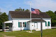
Hall Street School was built in 1887 and was added to the National Register of Historic Places on September 27, 2006.
References
- 1 2 3 4 5 6 2010 Census Gazetteer Files: New Jersey County Subdivisions, United States Census Bureau. Accessed May 21, 2015.
- 1 2 US Gazetteer files: 2010, 2000, and 1990, United States Census Bureau. Accessed September 4, 2014.
- 1 2 2012 New Jersey Legislative District Data Book, Rutgers University Edward J. Bloustein School of Planning and Public Policy, March 2013, p. 24.
- ↑ 2016 New Jersey Mayors Directory, New Jersey Department of Community Affairs. Accessed June 14, 2016.
- ↑ Business Administrator, Township of Monroe. Accessed July 6, 2016.
- ↑ Township Clerk, Township of Monroe. Accessed July 6, 2016.
- ↑ U.S. Geological Survey Geographic Names Information System: Township of Monroe, Geographic Names Information System. Accessed March 8, 2013.
- 1 2 3 4 5 6 DP-1 - Profile of General Population and Housing Characteristics: 2010 for Monroe township, Gloucester County, New Jersey, United States Census Bureau. Accessed November 7, 2012.
- 1 2 3 4 Municipalities Grouped by 2011-2020 Legislative Districts, New Jersey Department of State, p. 3. Accessed January 6, 2013.
- 1 2 3 Profile of General Demographic Characteristics: 2010 for Monroe township, New Jersey Department of Labor and Workforce Development. Accessed November 7, 2012.
- 1 2 PEPANNRES - Annual Estimates of the Resident Population: April 1, 2010 to July 1, 2015 - 2015 Population Estimates for New Jersey municipalities, United States Census Bureau. Accessed May 22, 2016.
- 1 2 GCT-PH1 Population, Housing Units, Area, and Density: 2010 - State -- County Subdivision from the 2010 Census Summary File 1 for New Jersey, United States Census Bureau. Accessed November 7, 2012.
- ↑ Look Up a ZIP Code for Williamstown, NJ, United States Postal Service. Accessed November 7, 2012.
- ↑ Area Code Lookup - NPA NXX for Williamstown, NJ, Area-Codes.com. Accessed October 22, 2013.
- 1 2 American FactFinder, United States Census Bureau. Accessed September 4, 2014.
- ↑ A Cure for the Common Codes: New Jersey, Missouri Census Data Center. Accessed October 29, 2012.
- ↑ US Board on Geographic Names, United States Geological Survey. Accessed September 4, 2014.
- ↑ Table 7. Population for the Counties and Municipalities in New Jersey: 1990, 2000 and 2010, New Jersey Department of Labor and Workforce Development, February 2011. Accessed November 7, 2012.
- ↑ Snyder, John P. The Story of New Jersey's Civil Boundaries: 1606-1968, Bureau of Geology and Topography; Trenton, New Jersey; 1969. p. 139. Accessed October 29, 2012.
- ↑ Hutchinson, Viola L. The Origin of New Jersey Place Names, New Jersey Public Library Commission, May 1945. Accessed September 7, 2015.
- ↑ DP-1 - Profile of General Population and Housing Characteristics: 2010 Demographic Profile Data for Victory Lakes CDP, New Jersey, United States Census Bureau. Accessed November 7, 2012.
- ↑ DP-1 - Profile of General Population and Housing Characteristics: 2010 Demographic Profile Data for Williamstown CDP, New Jersey, United States Census Bureau. Accessed November 7, 2012.
- ↑ New Jersey: 2010 - Population and Housing Unit Counts - 2010 Census of Population and Housing (CPH-2-32), United States Census Bureau, August 2012. Accessed November 7, 2012.
- ↑ Locality Search, State of New Jersey. Accessed May 21, 2015.
- ↑ Census Estimates for New Jersey April 1, 2010 to July 1, 2015, United States Census Bureau. Accessed May 22, 2016.
- ↑ Barnett, Bob. Population Data for Camden County Municipalities, 1850 - 2000, WestJersey.org, January 6, 2011. Accessed November 7, 2012.
- ↑ Barnett, Bob. Population Data for Gloucester County Municipalities, 1800 - 2000, WestJersey.org, January 6, 2011. Accessed November 7, 2012.
- ↑ Compendium of censuses 1726-1905: together with the tabulated returns of 1905, New Jersey Department of State, 1906. Accessed October 22, 2013.
- ↑ Raum, John O. The History of New Jersey: From Its Earliest Settlement to the Present Time, Volume 1, p. 279, J. E. Potter and company, 1877. Accessed October 22, 2013. "Monroe contained in 1860 a population of 1,417, and in 1870 1,663. Washington contained in 1850. a population of 2,114; in 1860, 1,307; and in 1870, 1,567. These two townships were set off from Camden county and annexed to Gloucester, February 28th, 1871."
- ↑ Staff. A compendium of the ninth census, 1870, p. 259. United States Census Bureau, 1872. Accessed October 22, 2013.
- ↑ Porter, Robert Percival. Preliminary Results as Contained in the Eleventh Census Bulletins: Volume III - 51 to 75, p. 98. United States Census Bureau, 1890. Accessed November 7, 2012.
- ↑ Thirteenth Census of the United States, 1910: Population by Counties and Minor Civil Divisions, 1910, 1900, 1890, United States Census Bureau, p. 336. Accessed November 7, 2012.
- ↑ Fifteenth Census of the United States : 1930 - Population Volume I, United States Census Bureau, p. 716. Accessed November 7, 2012.
- ↑ Table 6. New Jersey Resident Population by Municipality: 1930 - 1990, New Jersey Department of Labor and Workforce Development. Accessed June 28, 2015.
- 1 2 3 4 5 Census 2000 Profiles of Demographic / Social / Economic / Housing Characteristics for Monroe township, Gloucester County, New Jersey, United States Census Bureau. Accessed November 7, 2012.
- 1 2 3 4 5 DP-1: Profile of General Demographic Characteristics: 2000 - Census 2000 Summary File 1 (SF 1) 100-Percent Data for Monroe township, Gloucester County, New Jersey, United States Census Bureau. Accessed November 7, 2012.
- ↑ DP03: Selected Economic Characteristics from the 2006-2010 American Community Survey 5-Year Estimates for Monroe township, Gloucester County, New Jersey, United States Census Bureau. Accessed November 7, 2012.
- ↑ Home Page, Scotland Run Golf Club. Accessed July 8, 2015.
- ↑ "The Faulkner Act: New Jersey's Optional Municipal Charter Law", New Jersey State League of Municipalities, July 2007. Accessed October 22, 2013.
- ↑ Government Structure, accessed November 1, 2006
- ↑ Mayor, Township of Monroe. Accessed July 6, 2016. Council members are listed using tabs on top of page for "Township Council" and then "Council Members".
- ↑ Minutes Reorganization Meeting Township of Monroe January 4, 2016, Township of Monroe. Accessed July 6, 2016.
- ↑ 2016 Municipal Data Sheet, Township of Monroe. Accessed July 6, 2016.
- ↑ Gloucester County 2016 Official Directory, Gloucester County, New Jersey. Accessed July 5, 2016.
- ↑ 2014 General Election Unofficial Results, Gloucester County, New Jersey Clerk, updated November 13, 2014. Accessed July 5, 2016.
- ↑ 2012 General Election November 6, 2012 Summary Report Gloucester County, Gloucester County, New Jersey Clerk, November 28, 2012. Accessed July 6, 2016.
- ↑ Plan Components Report, New Jersey Redistricting Commission, December 23, 2011. Accessed January 6, 2013.
- ↑ 2016 New Jersey Citizen's Guide to Government, p. 61, New Jersey League of Women Voters. Accessed July 20, 2016.
- ↑ Districts by Number for 2011-2020, New Jersey Legislature. Accessed January 6, 2013.
- ↑ Directory of Representatives: New Jersey, United States House of Representatives. Accessed January 5, 2012.
- ↑ About Cory Booker, United States Senate. Accessed January 26, 2015. "He now owns a home and lives in Newark's Central Ward community."
- ↑ Biography of Bob Menendez, United States Senate, January 26, 2015. "He currently lives in Paramus and has two children, Alicia and Robert."
- ↑ Senators of the 114th Congress from New Jersey. United States Senate. Accessed January 26, 2015. "Booker, Cory A. - (D - NJ) Class II; Menendez, Robert - (D - NJ) Class I"
- ↑ Legislative Roster 2016-2017 Session, New Jersey Legislature. Accessed January 17, 2016.
- ↑ "About the Governor". State of New Jersey. Retrieved 2010-01-21.
- ↑ "About the Lieutenant Governor". State of New Jersey. Retrieved 2010-01-21.
- ↑ Robert M. Damminger, Gloucester County, New Jersey. Accessed February 3, 2016.
- ↑ Giuseppe (Joe) Chila, Gloucester County, New Jersey. Accessed February 3, 2016.
- ↑ Lyman Barnes, Gloucester County, New Jersey. Accessed February 3, 2016.
- ↑ Daniel Christy, Gloucester County, New Jersey. Accessed February 3, 2016.
- ↑ Frank J. DiMarco, Gloucester County, New Jersey. Accessed February 3, 2016.
- ↑ Heather Simmons, Gloucester County, New Jersey. Accessed February 3, 2016.
- ↑ Jim Jefferson, Gloucester County, New Jersey. Accessed February 3, 2016.
- ↑ Board of Freeholders, Gloucester County, New Jersey. Accessed February 3, 2016.
- 1 2 2014 Gloucester County Official Directory, Gloucester County, New Jersey. Accessed September 12, 2014.
- ↑ 2014 County Data Sheet, Gloucester County, New Jersey. Accessed September 12, 2014.
- ↑ James N. Hogan, Gloucester County, New Jersey. Accessed February 3, 2016.
- ↑ Surrogate Helene M. Reed, Gloucester County, New Jersey. Accessed February 3, 2016.
- ↑ Sheriff Carmel M. Morina, Gloucester County, New Jersey. Accessed February 3, 2016.
- ↑ Row Officers, Gloucester County, New Jersey. Accessed February 3, 2016.
- ↑ Voter Registration Summary - Gloucester, New Jersey Department of State Division of Elections, March 23, 2011. Accessed November 7, 2012.
- ↑ "Presidential General Election Results - November 6, 2012 - Gloucester County" (PDF). New Jersey Department of Elections. March 15, 2013. Retrieved December 24, 2014.
- ↑ "Number of Registered Voters and Ballots Cast - November 6, 2012 - General Election Results - Gloucester County" (PDF). New Jersey Department of Elections. March 15, 2013. Retrieved December 24, 2014.
- ↑ 2008 Presidential General Election Results: Gloucester County, New Jersey Department of State Division of Elections, December 23, 2008. Accessed November 7, 2012.
- ↑ 2004 Presidential Election: Gloucester County, New Jersey Department of State Division of Elections, December 13, 2004. Accessed November 7, 2012.
- ↑ "Governor - Gloucester County" (PDF). New Jersey Department of Elections. January 29, 2014. Retrieved December 24, 2014.
- ↑ "Number of Registered Voters and Ballots Cast - November 5, 2013 - General Election Results - Gloucester County" (PDF). New Jersey Department of Elections. January 29, 2014. Retrieved December 24, 2014.
- ↑ 2009 Governor: Gloucester County, New Jersey Department of State Division of Elections, December 31, 2009. Accessed November 7, 2012.
- ↑ District information for Monroe Township School District, National Center for Education Statistics. Accessed December 30, 2014.
- ↑ School Data for the Monroe Township Public Schools, National Center for Education Statistics. Accessed December 30, 2014.
- ↑ Holly Glen Elementary School, Monroe Township Public Schools. Accessed October 22, 2013.
- ↑ Oak Knoll Elementary School, Monroe Township Public Schools. Accessed October 22, 2013.
- ↑ Radix Elementary School, Monroe Township Public Schools. Accessed October 22, 2013.
- ↑ Whitehall Elementary School, Monroe Township Public Schools. Accessed October 22, 2013.
- ↑ Williamstown Middle School, Monroe Township Public Schools. Accessed October 22, 2013.
- ↑ Williamstown High School, Monroe Township Public Schools. Accessed October 22, 2013.
- ↑ New Jersey School Directory for the Monroe Township Public Schools, New Jersey Department of Education. Accessed October 22, 2013.
- ↑ About, St. Mary School. Accessed October 20, 2016.
- ↑ Catholic Schools Directory, Roman Catholic Diocese of Camden. Accessed October 20, 2016.
- ↑ Gloucester County Mileage by Municipality and Jurisdiction, New Jersey Department of Transportation, May 2010. Accessed July 18, 2014.
- ↑ Gloucester County Bus / Rail Connections, NJ Transit, backed up by the Internet Archive as of July 26, 2010. Accessed November 6, 2012.
- ↑ South Jersey Transit Guide, Cross County Connection, as of April 1, 2010. Accessed October 5, 2014.
- ↑ "Pilot survives small plane crash", WPVI, July 16, 2008. Accessed July 28, 2008. "Chopper 6 was over Cross Keys Airport in Monroe Township, Gloucester County."
- ↑ Roberts, Kimberly C. "Leon Huff takes vocal group Ju-Taun under his wing", The Philadelphia Tribune, December 5, 2011. Accessed July 8, 2015. "His recent connection with vocal group Ju-Taun, of Williamstown, N.J., has reignited that passion."
External links
| Wikimedia Commons has media related to Monroe Township, Gloucester County, New Jersey. |
- Monroe Township website
- Monroe Township Public Schools
- Monroe Township Public Schools's 2014–15 School Report Card from the New Jersey Department of Education
- School Data for the Monroe Township Public Schools, National Center for Education Statistics

| Counties |  | |
|---|---|---|
| Major cities | ||
| Cities and towns 50k-99k | ||
| Cities and towns 30k-50k | ||
 |
Washington Township | Gloucester Township | Winslow Township | |
| Clayton Glassboro |
|
|||
| ||||
| | ||||
| Franklin Township | Folsom Buena Vista Township |