Black River Falls, Wisconsin
| Black River Falls, Wisconsin Nįoxawanį | |
|---|---|
| City | |
|
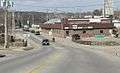
Looking west at downtown Black River Falls on WIS 54 | |
 Location of Black River Falls, Wisconsin | |
| Coordinates: 44°17′50″N 90°50′57″W / 44.29722°N 90.84917°WCoordinates: 44°17′50″N 90°50′57″W / 44.29722°N 90.84917°W | |
| Country | United States |
| State | Wisconsin |
| County | Jackson |
| Area[1] | |
| • Total | 4.20 sq mi (10.88 km2) |
| • Land | 4.10 sq mi (10.62 km2) |
| • Water | 0.10 sq mi (0.26 km2) |
| Elevation[2] | 794 ft (242 m) |
| Population (2010)[3] | |
| • Total | 3,622 |
| • Estimate (2012[4]) | 3,583 |
| • Density | 883.4/sq mi (341.1/km2) |
| Time zone | Central (CST) (UTC-6) |
| • Summer (DST) | CDT (UTC-5) |
| Area code(s) | 715 & 534 |
| FIPS code | 55-07900[5] |
| GNIS feature ID | 1561883[2] |

Black River Falls is a city in Jackson County, Wisconsin, USA. The population was 3,622 at the 2010 census. It is Jackson County's county seat.[6] The Ho-Chunk Nation has its administrative center in Black River Falls.
History
.jpg)
Black River Falls was founded to utilize the waterpower of the Black River. As the area was predominantly forest at the time, its primary use was in operating sawmills. Some of the lumber produced was used in the construction of the Mormon temple at Nauvoo, Illinois.[7]
A large monument to Black River Falls' veterans of World War I, World War II, the Korean War, and the Vietnam War, as well as to local Medal of Honor recipient Mitchell Red Cloud, Jr., was erected near the Chamber of Commerce Building at 101 S. 2nd Street. Named the "Field of Honor", the attached plaques provide accounts of the veterans' services. This site is also the start of the four-mile (6.5 km) Foundation Trail, a signed hiking and bike path that circles the eastern part of the community.
Black River Falls is the focus of Michael Lesy's book Wisconsin Death Trip (1973), which used photographs and newspaper cuttings to highlight the harshness of life in the community during the late nineteenth century and the effects it had on the psychology of the inhabitants.
Geography
Black River Falls is located at 44°17′50″N 90°50′57″W / 44.29722°N 90.84917°W (44.297166, -90.849263).[8] According to the United States Census Bureau, the city has a total area of 4.20 square miles (10.88 km2), of which, 4.10 square miles (10.62 km2) is land and 0.10 square miles (0.26 km2) is water.[1]
The city is located on the falls of the Black River at the northeast edge of the Driftless Area, where the river cuts through a region of granite.[9] The falls are covered by a hydroelectric dam, forming the 200-acre (0.81 km2) Black River Flowage.[10]
Demographics
| Historical population | |||
|---|---|---|---|
| Census | Pop. | %± | |
| 1860 | 570 | — | |
| 1870 | 1,101 | 93.2% | |
| 1880 | 1,427 | 29.6% | |
| 1890 | 2,261 | 58.4% | |
| 1900 | 1,938 | −14.3% | |
| 1910 | 1,917 | −1.1% | |
| 1920 | 1,796 | −6.3% | |
| 1930 | 1,950 | 8.6% | |
| 1940 | 2,539 | 30.2% | |
| 1950 | 2,824 | 11.2% | |
| 1960 | 3,195 | 13.1% | |
| 1970 | 3,273 | 2.4% | |
| 1980 | 3,434 | 4.9% | |
| 1990 | 3,490 | 1.6% | |
| 2000 | 3,618 | 3.7% | |
| 2010 | 3,622 | 0.1% | |
| Est. 2015 | 3,564 | [11] | −1.6% |
2010 census
As of the census[3] of 2010, there were 3,622 people, 1,613 households, and 845 families residing in the city. The population density was 883.4 inhabitants per square mile (341.1/km2). There were 1,732 housing units at an average density of 422.4 per square mile (163.1/km2). The racial makeup of the city was 91.5% White, 0.5% African American, 5.2% Native American, 0.3% Asian, 0.2% from other races, and 2.3% from two or more races. Hispanic or Latino of any race were 1.7% of the population.
There were 1,613 households of which 26.2% had children under the age of 18 living with them, 36.7% were married couples living together, 11.7% had a female householder with no husband present, 4.0% had a male householder with no wife present, and 47.6% were non-families. 41.5% of all households were made up of individuals and 17.4% had someone living alone who was 65 years of age or older. The average household size was 2.13 and the average family size was 2.89.
The median age in the city was 41.6 years. 22.8% of residents were under the age of 18; 6.8% were between the ages of 18 and 24; 24.4% were from 25 to 44; 24.7% were from 45 to 64; and 21.2% were 65 years of age or older. The gender makeup of the city was 48.4% male and 51.6% female.
2000 census
As of the census[5] of 2000, there were 3,618 people, 1,563 households, and 886 families residing in the city. The population density was 1,146.4 people per square mile (442.1/km²). There were 1,679 housing units at an average density of 532.0 per square mile (205.1/km²). The racial makeup of the city was 93.37% White, 0.19% African American, 4.73% Native American, 0.11% Asian, 0.08% Pacific Islander, 0.55% from other races, and 0.97% from two or more races. Hispanic or Latino of any race were 1.16% of the population.
There were 1,563 households out of which 25.8% had children under the age of 18 living with them, 43.4% were married couples living together, 10.2% had a female householder with no husband present, and 43.3% were non-families. 38.0% of all households were made up of individuals and 19.6% had someone living alone who was 65 years of age or older. The average household size was 2.15 and the average family size was 2.82.
In the city the population was spread out with 20.8% under the age of 18, 8.9% from 18 to 24, 24.2% from 25 to 44, 21.3% from 45 to 64, and 24.8% who were 65 years of age or older. The median age was 42 years. For every 100 females there were 87.1 males. For every 100 females age 18 and over, there were 81.3 males.
The median income for a household in the city was $33,555, and the median income for a family was $46,222. Males had a median income of $31,481 versus $18,519 for females. The per capita income for the city was $21,532. About 3.7% of families and 7.7% of the population were below the poverty line, including 5.4% of those under age 18 and 10.4% of those age 65 or over.
Economy
While the logging and lumber industry is still present in the area, the current economy leans heavily on agriculture and tourism. Several locations support the tourism industry. Lake Arbutus, a 839-acre (3.40 km2) impoundment of the river, lies several miles northeast, as does the multi-use Levis/Trow trail system. Black River Falls is home to a casino and hotel operated by the Ho-Chunk Nation. Much of the surrounding land is part of the Black River State Forest
Government

City Hall, located at 101 S. 2nd St, houses the mayor, Ron Danielson; the city administrator, Bill Arndt; deputy city clerks and treasurers; the Parks and Recreation Department and the Police Department. Offices for Jackson County are located on Main Street.[13]
Education
Black River Falls High School, the city's public high school located on the southwestern edge of town, is administered by the Black River Falls School District. The former high school, in the center of the city, has been converted to apartments. Western Technical College offers classes in the city.
Media
Despite its size, Black River Falls has two newspapers, both published weekly: the Banner-Journal and the Jackson County Chronicle.
Local stations WWIS-FM 99.7 FM WWIS 1260 AM
Far-away stations WXYM 96.1 FM
Culture
Black River Falls is the focus of Michael Lesy's book Wisconsin Death Trip (1973), which used photographs and newspaper cuttings to highlight the harshness of life in the community during the late nineteenth century and the effects it had on the psychology of the inhabitants. The book was made into a film in 1999, which included scenes from the community as it appeared then.
Lesy drew on the work of Charles Van Schaick, a photographer in Black River Falls between the 1870s and 1930s. Van Schaick made portraits of the Ho-Chunk (Winnebago) people in the area in his commercial studio in downtown Black River Falls. His photographs are now housed at the Wisconsin Historical Society and were the subject of a book, People of the Big Voice, published in 2011.[14]
The Black River Falls area is home to a large population of the endangered Karner Blue butterfly. The city celebrates with the Karner Blue Butterfly Festival held annually on the third Saturday of July.
Transportation
Major highways
The primary artery of transportation for Black River Falls is Interstate 94, which passes through the eastern edge of the city. US Highway 12, Wisconsin Highway 27, and Wisconsin Highway 54 also pass through the city.
Airport
Black River Falls Area Airport (KBCK) serves the city and surrounding communities.
Rail
The Union Pacific Railroad is adjacent to the city, but does not pass through the center.[15]
Notable people
- Simon Benson - Oregon businessman
- Eustace L. Brockway - Wisconsin State Assembly
- David W. Cheney - Wisconsin State Assembly
- Larry D. Gilbertson - Wisconsin State Assembly
- Lawrence M. Hagen - Wisconsin State Assembly
- Phil Haugstad - baseball player
- Merlin Hull - U.S. Representative
- Calvin R. Johnson - Wisconsin State Assembly
- Lester Johnson - U.S. Representative
- Oswald H. Johnson - Wisconsin State Assembly[16]
- Truman Lowe - Native American sculptor
- James J. McGillivray - Wisconsin State Assembly and Senate
- Hugh Brooks Mills - politician and businessman
- Terry Musser - Wisconsin State Assembly
- Merlin J. Peterson - Wisconsin State Assembly
- Carl C. Pope - Wisconsin legislator and jurist[17]
- Hugh H. Price - U.S. Representative
- William T. Price - U.S. Representative
- Ernie Rudolph - MLB player
- Jack Taylor - College Basketball record holder
- Casper D. Waller - Wisconsin State Assembly
Images
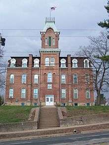
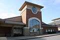
-
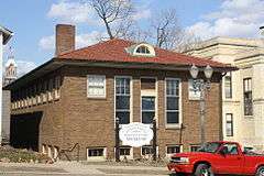
Black River Falls Public Library; the former library is now a museum
-
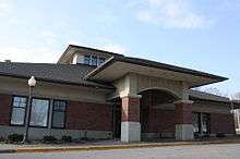
Current library
-
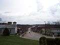
Panorama looking east
-
City hall
-
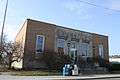
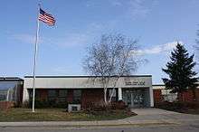
Post office
-
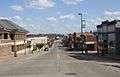
Looking east in downtown Black River Falls
-
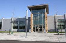
Western Technical College campus
References
- 1 2 "US Gazetteer files 2010". United States Census Bureau. Archived from the original on 2012-01-24. Retrieved 2012-11-18.
- 1 2 "US Board on Geographic Names". United States Geological Survey. 2007-10-25. Retrieved 2008-01-31.
- 1 2 "American FactFinder". United States Census Bureau. Retrieved 2012-11-18.
- ↑ "Population Estimates". United States Census Bureau. Archived from the original on 2013-06-17. Retrieved 2013-06-24.
- 1 2 "American FactFinder". United States Census Bureau. Archived from the original on 2013-09-11. Retrieved 2008-01-31.
- ↑ "Find a County". National Association of Counties. Archived from the original on 2011-05-31. Retrieved 2011-06-07.
- ↑ blackriverfalls.com - Home Archived February 9, 2008, at the Wayback Machine.
- ↑ "US Gazetteer files: 2010, 2000, and 1990". United States Census Bureau. 2011-02-12. Retrieved 2011-04-23.
- ↑ "Archived copy". Archived from the original on 2009-08-13. Retrieved 2009-07-04. Jackson County Website
- ↑ Black River - WDNR Archived October 10, 2007, at the Wayback Machine.
- ↑ "Annual Estimates of the Resident Population for Incorporated Places: April 1, 2010 to July 1, 2015". Retrieved July 2, 2016.
- ↑ "Census of Population and Housing". Census.gov. Archived from the original on May 11, 2015. Retrieved June 4, 2015.
- ↑ "Archived copy". Archived from the original on 2009-08-13. Retrieved 2009-07-04. Jackson County Offices
- ↑ http://stephenjessetaylor.wordpress.com/2013/07/25/charles-van-schaick-a-voice-from-the-passion-of-nature/
- ↑ Wisconsin DOT Railway Map
- ↑ 'Wisconsin Blue Book 1942,' Biographical Sketch of Oswald H. Johnson, pg. 47
- ↑ 'Wisconsin Blue Book 1877,' Biographical Sketch of Carl C. Pope, pg. 463
External links
| Wikimedia Commons has media related to Black River Falls, Wisconsin. |
Municipalities and communities of Jackson County, Wisconsin, United States | ||
|---|---|---|
| City | 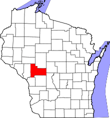 | |
| Villages | ||
| Towns | ||
| CDPs | ||
| Unincorporated communities | ||
| Ghost towns | ||
| Indian reservation | ||
| Footnotes | ‡This populated place also has portions in an adjacent county or counties | |