Bladen County, North Carolina
| Bladen County, North Carolina | ||
|---|---|---|
| ||
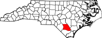 Location in the U.S. state of North Carolina | ||
 North Carolina's location in the U.S. | ||
| Founded | 1739 | |
| Named for | Martin Bladen | |
| Seat | Elizabethtown | |
| Largest town | Elizabethtown | |
| Area | ||
| • Total | 887 sq mi (2,297 km2) | |
| • Land | 874 sq mi (2,264 km2) | |
| • Water | 13 sq mi (34 km2), 1.4% | |
| Population | ||
| • (2010) | 35,190 | |
| • Density | 40/sq mi (15/km²) | |
| Congressional district | 7th | |
| Time zone | Eastern: UTC-5/-4 | |
| Website |
www | |

Bladen /ˈbleɪdɛn/ [1] County is a county located in the U.S. state of North Carolina. As of the 2010 Census, the population was 35,190.[2] Its county seat is Elizabethtown.[3] The county was created in 1734 as Bladen Precinct and gained county status in 1739.[4]
History
Bladen County was formed in 1734 as Bladen Precinct of Bath County, from New Hanover Precinct. It was named for Martin Bladen, a member of the Board of Trade.[5] With the abolition of Bath County in 1739, all of its constituent precincts became counties.
Originally, Bladen was a vast territory with indefinite northern and western boundaries. Reductions in its extent began in 1750, when its western part became Anson County. In 1752 the northern part of Bladen County was combined with parts of Granville County and Johnston County to form Orange County. In 1754 the northern part of what was left of Bladen County became Cumberland County. In 1764 the southern part of what remained of Bladen County was combined with part of New Hanover County to form Brunswick County. In 1787 the western part of the now much smaller county became Robeson County. Finally, in 1808 the southern part of Bladen County was combined with part of Brunswick County to form Columbus County. Bladen County is considered the "mother county" of North Carolina because of the 100 counties in North Carolina, 55 of them at one point belonged to Bladen County. It is also the fourth largest county in North Carolina.
Geography
According to the U.S. Census Bureau, the county has a total area of 887 square miles (2,300 km2), of which 874 square miles (2,260 km2) is land and 13 square miles (34 km2) (1.4%) is water.[6] It is the fourth-largest county in North Carolina by land area.
Adjacent counties
- Cumberland County - north
- Sampson County - northeast
- Pender County - southeast
- Columbus County - south
- Robeson County - west
Major highways
Demographics
| Historical population | |||
|---|---|---|---|
| Census | Pop. | %± | |
| 1790 | 5,100 | — | |
| 1800 | 7,028 | 37.8% | |
| 1810 | 5,671 | −19.3% | |
| 1820 | 7,276 | 28.3% | |
| 1830 | 7,811 | 7.4% | |
| 1840 | 8,022 | 2.7% | |
| 1850 | 9,767 | 21.8% | |
| 1860 | 11,995 | 22.8% | |
| 1870 | 12,831 | 7.0% | |
| 1880 | 16,158 | 25.9% | |
| 1890 | 16,763 | 3.7% | |
| 1900 | 17,677 | 5.5% | |
| 1910 | 18,006 | 1.9% | |
| 1920 | 19,761 | 9.7% | |
| 1930 | 22,389 | 13.3% | |
| 1940 | 27,156 | 21.3% | |
| 1950 | 29,703 | 9.4% | |
| 1960 | 28,881 | −2.8% | |
| 1970 | 26,477 | −8.3% | |
| 1980 | 30,491 | 15.2% | |
| 1990 | 28,663 | −6.0% | |
| 2000 | 32,278 | 12.6% | |
| 2010 | 35,190 | 9.0% | |
| Est. 2015 | 34,318 | [7] | −2.5% |
| U.S. Decennial Census[8] 1790-1960[9] 1900-1990[10] 1990-2000[11] 2010-2013[2] | |||
As of the census[12] of 2000, there were 32,278 people, 12,897 households, and 8,937 families residing in the county. The population density was 37 people per square mile (14/km²). There were 15,316 housing units at an average density of 18 per square mile (7/km²). The racial makeup of the county was 57.22% White, 37.91% Black or African American, 2.04% Native American, 0.10% Asian, 0.04% Pacific Islander, 1.97% from other races, and 0.73% from two or more races. 3.71% of the population were Hispanic or Latino of any race.
By 2005 55.8% of the population of Bladen County was non-Hispanic whites. 36.8% of the population was African-American. 5.0% of the population of was Latino. 2.3% of the population was Native American.
There were 12,897 households out of which 30.40% had children under the age of 18 living with them, 48.90% were married couples living together, 15.70% had a female householder with no husband present, and 30.70% were non-families. 27.70% of all households were made up of individuals and 11.50% had someone living alone who was 65 years of age or older. The average household size was 2.45 and the average family size was 2.97.
In the county the population was spread out with 24.60% under the age of 18, 8.70% from 18 to 24, 27.20% from 25 to 44, 25.20% from 45 to 64, and 14.20% who were 65 years of age or older. The median age was 38 years. For every 100 females there were 92.60 males. For every 100 females age 18 and over, there were 88.70 males.
The median income for a household in the county was $26,877, and the median income for a family was $33,974. Males had a median income of $27,799 versus $21,973 for females. The per capita income for the county was $14,735. About 16.60% of families and 21.00% of the population were below the poverty line, including 28.70% of those under age 18 and 24.20% of those age 65 or over.
Law and government
Bladen County is a member of the regional Lumber River Council of Governments.
Communities
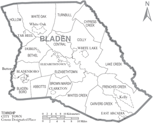
Towns
- Bladenboro
- Clarkton
- Dublin
- East Arcadia
- Elizabethtown (county seat)
- Tar Heel
- White Lake
Census-designated places
Unincorporated communities
Townships
- Abbottsburg
- Bethel
- Bladenboro
- Brown Marsh
- Carvers Creek
- Central
- Clarkton
- Colly
- Cypress Creek
- Elizabethtown
- East Arcadia
- Frenches Creek
- Hollow
- Lake Creek
- Tarheel
- Turnbull
- White Oak
- Dublin
- Whites Creek
Population ranking
The population ranking of the following table is based on the 2010 census of Bladen County.[13]
† county seat
| Rank | City/Town/etc. | Municipal type | Population (2010 Census)
|
|---|---|---|---|
| 1 | † Elizabethtown | Town | 3,583 |
| 2 | Bladenboro | Town | 1,750 |
| 3 | Clarkton | Town | 837 |
| 4 | White Lake | Town | 802 |
| 5 | Kelly | CDP | 544 |
| 6 | East Arcadia | Town | 487 |
| t-7 | Dublin | Town | 338 |
| t-7 | White Oak | CDP | 338 |
| 8 | Butters | CDP | 294 |
| 9 | Tar Heel | Town | 117 |
Other notable information
Bladen County is also the home of the oldest documented Taxodium distichum (bald cypress) at 1622 years old.[14]
See also
References
- ↑ Talk Like A Tarheel, from the North Carolina Collection's website at the University of North Carolina at Chapel Hill. Retrieved 2013-02-08.
- 1 2 "State & County QuickFacts". United States Census Bureau. Retrieved October 17, 2013.
- ↑ "Find a County". National Association of Counties. Archived from the original on 2011-05-31. Retrieved 2011-06-07.
- ↑ "North Carolina: Individual County Chronologies". North Carolina Atlas of Historical County Boundaries. The Newberry Library. 2009. Retrieved January 20, 2015.
- ↑ Proffitt, Martie (Apr 17, 1983). "Local history offers tasty tidbits". Star-News. pp. 1C. Retrieved 1 November 2015.
- ↑ "2010 Census Gazetteer Files". United States Census Bureau. August 22, 2012. Retrieved January 12, 2015.
- ↑ "County Totals Dataset: Population, Population Change and Estimated Components of Population Change: April 1, 2010 to July 1, 2015". Retrieved July 2, 2016.
- ↑ "U.S. Decennial Census". United States Census Bureau. Archived from the original on May 11, 2015. Retrieved January 12, 2015.
- ↑ "Historical Census Browser". University of Virginia Library. Retrieved January 12, 2015.
- ↑ Forstall, Richard L., ed. (March 27, 1995). "Population of Counties by Decennial Census: 1900 to 1990". United States Census Bureau. Retrieved January 12, 2015.
- ↑ "Census 2000 PHC-T-4. Ranking Tables for Counties: 1990 and 2000" (PDF). United States Census Bureau. April 2, 2001. Retrieved January 12, 2015.
- ↑ "American FactFinder". United States Census Bureau. Archived from the original on 2013-09-11. Retrieved 2008-01-31.
- ↑ "Archived copy". Archived from the original on 2013-12-21. Retrieved 2016-02-13.
- ↑ Eastern OLDLIST. Rocky Mountain Tree-Ring Research, Inc. & Eastern Kentucky University http://www.ldeo.columbia.edu/~adk/oldlisteast/Spp/TADI.html. Retrieved 3 November 2013. Missing or empty
|title=(help)
External links
- Official website
- Bladen Journal, Google news archive. —PDFs of 2,696 issues, dating from 1929 to 1985.
 |
Cumberland County | Sampson County | | |
| Robeson County | |
|||
| ||||
| | ||||
| Columbus County | Pender County |
Municipalities and communities of Bladen County, North Carolina, United States | ||
|---|---|---|
| Towns |  | |
| CDPs | ||
| Unincorporated communities | ||
Coordinates: 34°37′N 78°34′W / 34.62°N 78.56°W