Richmond County, North Carolina
| Richmond County, North Carolina | |
|---|---|
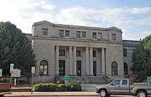 Richmond County Courthouse in Rockingham | |
 Location in the U.S. state of North Carolina | |
 North Carolina's location in the U.S. | |
| Founded | 1779 |
| Named for | Charles Lennox, 3rd Duke of Richmond and Lennox |
| Seat | Rockingham |
| Largest city | Rockingham |
| Area | |
| • Total | 480 sq mi (1,243 km2) |
| • Land | 474 sq mi (1,228 km2) |
| • Water | 6.1 sq mi (16 km2), 1.3% |
| Population | |
| • (2010) | 46,639 |
| • Density | 98/sq mi (38/km²) |
| Congressional district | 8th |
| Time zone | Eastern: UTC-5/-4 |
| Website |
www |
Richmond County is a county located in the U.S. state of North Carolina. As of the 2010 Census, the population was 46,639.[1] Its county seat is Rockingham.[2]
Richmond County comprises the Rockingham, NC Micropolitan Statistical Area.
History
The county was formed in 1779 from Anson County. It was named for Charles Lennox, 3rd Duke of Richmond and Lennox who was an Englishman and a member of the Parliament of the United Kingdom who sided with the colonists in America during the American Revolution.
In 1899 the southeastern part of Richmond County became Scotland County.
Kader Keaton, a colonial American officer in the American Revolutionary War, was a founder of Anglo-American settlement in Richmond County.
Railroads
The city of Hamlet in the southeastern sector of Richmond County is known for its railway history. Prior to the turn of the 20th century, the Seaboard Air Line Railroad moved to Hamlet, helping the town become a crossroads for rail spurs extending from Florida to New York and all points east and west. In 1900, the SAL Railroad constructed the Hamlet Historical Depot Seaboard Air Line Passenger Depot, a Victorian architecture train station which is one of the most photographed train stations in the eastern United States. The depot was added to the National Register of Historic Places in 1971 and was fully restored in 2004. In 2009, the city of Hamlet dedicated a new building to the Tornado steam engine locomotive—the first one in the State of North Carolina. The original locomotive was built in 1839 by D.J. Burr & Associates of Richmond, Virginia. It was briefly captured by Federal forces during the American Civil War before being repatriated. In 1892, the Tornado was featured in the Great Centennial Celebration of Raleigh, NC. Hamlet is also home to the National Railroad Museum and Hall of Fame, a striking collection of artifacts from the Seaboard Air Line Railroad spanning decades of time.
Geography
According to the U.S. Census Bureau, the county has a total area of 480 square miles (1,200 km2), of which 474 square miles (1,230 km2) is land and 6.1 square miles (16 km2) (1.3%) is water.[3]
Major highways
Adjacent counties
- Montgomery County - north
- Moore County - northeast
- Scotland County - southeast
- Marlboro County, South Carolina - south
- Anson County - west
National protected area
Demographics
| Historical population | |||
|---|---|---|---|
| Census | Pop. | %± | |
| 1790 | 5,053 | — | |
| 1800 | 5,623 | 11.3% | |
| 1810 | 6,695 | 19.1% | |
| 1820 | 7,537 | 12.6% | |
| 1830 | 9,396 | 24.7% | |
| 1840 | 8,909 | −5.2% | |
| 1850 | 9,818 | 10.2% | |
| 1860 | 11,009 | 12.1% | |
| 1870 | 12,882 | 17.0% | |
| 1880 | 18,245 | 41.6% | |
| 1890 | 23,948 | 31.3% | |
| 1900 | 15,855 | −33.8% | |
| 1910 | 19,673 | 24.1% | |
| 1920 | 25,567 | 30.0% | |
| 1930 | 34,016 | 33.0% | |
| 1940 | 36,810 | 8.2% | |
| 1950 | 39,597 | 7.6% | |
| 1960 | 39,202 | −1.0% | |
| 1970 | 39,889 | 1.8% | |
| 1980 | 45,481 | 14.0% | |
| 1990 | 44,518 | −2.1% | |
| 2000 | 46,564 | 4.6% | |
| 2010 | 46,639 | 0.2% | |
| Est. 2015 | 45,437 | [4] | −2.6% |
| U.S. Decennial Census[5] 1790-1960[6] 1900-1990[7] 1990-2000[8] 2010-2013[1] | |||
As of the census[9] of 2000, there were 46,564 people, 17,873 households, and 12,582 families residing in the county. The population density was 98 people per square mile (38/km²). There were 19,886 housing units at an average density of 42 per square mile (16/km²). The racial makeup of the county was 64.84% White, 30.53% Black or African American, 1.65% Native American, 0.68% Asian, 0.03% Pacific Islander, 1.08% from other races, and 1.18% from two or more races. 2.83% of the population were Hispanic or Latino of any race.
In 2005 62.0% of Richmond County's population was non-Hispanic whites. 30.9% of the population was African-American. 3.9% of the population was Latino. 1.9% of the population was Native American.
There were 17,873 households out of which 32.10% had children under the age of 18 living with them, 48.30% were married couples living together, 17.00% had a female householder with no husband present, and 29.60% were non-families. 26.30% of all households were made up of individuals and 11.20% had someone living alone who was 65 years of age or older. The average household size was 2.51 and the average family size was 3.01.
In the county the population was spread out with 25.80% under the age of 18, 10.10% from 18 to 24, 27.70% from 25 to 44, 22.80% from 45 to 64, and 13.60% who were 65 years of age or older. The median age was 36 years. For every 100 females there were 96.30 males. For every 100 females age 18 and over, there were 92.70 males.
The median income for a household in the county was $28,830, and the median income for a family was $35,226. Males had a median income of $27,308 versus $20,453 for females. The per capita income for the county was $14,485. About 15.90% of families and 19.60% of the population were below the poverty line, including 26.70% of those under age 18 and 18.90% of those age 65 or over.
Law and government
Richmond County is a member of the regional Lumber River Council of Governments.
As of the 2000 Census, Richmond County is located entirely in North Carolina's 8th congressional district and is currently represented in the 113th United States Congress by Richard Hudson (R).
Attractions
Racing
Richmond County is well known for its history in racing, with the advent of the Rockingham Speedway which opened in 1965. Until 2005, this one-mile race track featured bi-annual NASCAR-sanctioned events in the Sprint Cup and Nationwide Series divisions. Presently, the race track hosts several other events hosted by sanctioning bodies including ARCA, USAR Pro Cup, and UARA Late Models. Rockingham also includes a weekly scheduled series of events for Bandolero and Legends race car classes at the 1/2 mile infield track dubbed the "Little Rock". Richmond County also hosts lawnmower races. Each weekend from April–October, the Lion's Club of Ellerbe puts on a weekly show, attracting fans and competitors from surrounding counties and states.
The County is also host to Rockingham Dragway, an International Hot Rod Association-sanctioned drag strip, which hosts over 90 drag racing events per year.
Outdoors
Richmond County also has notable options for both fishing and hunting. Richmond County is home to the Sandhills Game Lands and the Pee Dee Wildlife Refuge, where activities such as hiking, biking, horseback riding, boating, and hunting are available to the public. Popular hunting game include deer, turkey, quail, and fox squirrels. Blewett Falls Reservoir is the largest lake in the county, offering fishing opportunities for Big Blue and Flathead Catfish as well as Striped Bass and Shad. Rockingham is working on developing a 10-mile "Blue Trail" for paddling and canoeing along Hitchcock Creek and a four-mile stretch of the Pee Dee River, with camping allowed at the final portage point - Diggs Tract.
Communities
Cities
- Hamlet
- Rockingham (county seat)
Towns
Census-designated places
Unincorporated communities
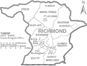
Townships
- Steeles
- Mineral Springs
- Beaverdam
- Mark's Creek
- Wolf Pit
- Rockingham
- Blackjack
Notable people
- Wayne Goodwin, North Carolina's elected Insurance Commissioner as a result of the 2008 election.
- Henry Frye, former member of the North Carolina General Assembly (state legislature), and former Chief Justice of the North Carolina Supreme Court.
- Leon Levine, founder of Family Dollar.
- John Coltrane, American Jazz Saxophonist.
- Cameron A. Morrison, Governor of North Carolina, U.S. Senator, U.S. Representative and Mayor of Rockingham.
- Terius Youngdell Nash, or "The-Dream" is a Grammy Award nominated American singer-songwriter and record producer.
- Bucky Covington, country singer and American Idol contestant.
- Dannell Ellerbe - Outside linebacker for the New Orlean Saints (NFL).
- Melvin Ingram - Outside linebacker for the San Diego Chargers (NFL).
- Christopher Davis - Singer/Songwriter formerly known as Carolinerboy.
See also
References
- 1 2 "State & County QuickFacts". United States Census Bureau. Retrieved October 29, 2013.
- ↑ "Find a County". National Association of Counties. Archived from the original on May 31, 2011. Retrieved 2011-06-07.
- ↑ "2010 Census Gazetteer Files". United States Census Bureau. August 22, 2012. Retrieved January 19, 2015.
- ↑ "County Totals Dataset: Population, Population Change and Estimated Components of Population Change: April 1, 2010 to July 1, 2015". Retrieved July 2, 2016.
- ↑ "U.S. Decennial Census". United States Census Bureau. Archived from the original on May 11, 2015. Retrieved January 19, 2015.
- ↑ "Historical Census Browser". University of Virginia Library. Retrieved January 19, 2015.
- ↑ Forstall, Richard L., ed. (March 27, 1995). "Population of Counties by Decennial Census: 1900 to 1990". United States Census Bureau. Retrieved January 19, 2015.
- ↑ "Census 2000 PHC-T-4. Ranking Tables for Counties: 1990 and 2000" (PDF). United States Census Bureau. April 2, 2001. Retrieved January 19, 2015.
- ↑ "American FactFinder". United States Census Bureau. Archived from the original on September 11, 2013. Retrieved 2008-01-31.
External links
- Richmond County government official website
- Richmond County Tourism Development Authority
- NCGenWeb Richmond County - free genealogy resources for the county
 |
Montgomery County | Moore County | | |
| Anson County | |
|||
| ||||
| | ||||
| Marlboro County, South Carolina | Scotland County |
Municipalities and communities of Richmond County, North Carolina, United States | ||
|---|---|---|
| City |  | |
| Towns | ||
| CDPs | ||
| Unincorporated communities | ||
Coordinates: 35°00′N 79°45′W / 35.00°N 79.75°W