Blanket, Texas
| Blanket, Texas | |
|---|---|
| Town | |
|
| |
|
Location of Blanket, Texas | |
|
| |
| Coordinates: 31°49′35″N 98°47′17″W / 31.82639°N 98.78806°WCoordinates: 31°49′35″N 98°47′17″W / 31.82639°N 98.78806°W | |
| Country | United States |
| State | Texas |
| County | Brown |
| Area | |
| • Total | 0.6 sq mi (1.6 km2) |
| • Land | 0.6 sq mi (1.6 km2) |
| • Water | 0.0 sq mi (0.0 km2) |
| Elevation | 1,621 ft (494 m) |
| Population (2010) | |
| • Total | 390 |
| • Density | 635/sq mi (245.2/km2) |
| Time zone | Central (CST) (UTC-6) |
| • Summer (DST) | CDT (UTC-5) |
| ZIP code | 76432 |
| Area code(s) | 325 |
| FIPS code | 48-08596[1] |
| GNIS feature ID | 1330841[2] |
Blanket is a town located in Brown County in west-central Texas, United States. The population was 390 at the 2010 census.[3]
Geography
Blanket is located in eastern Brown County at 31°49′35″N 98°47′17″W / 31.82639°N 98.78806°W (31.826469, -98.788172).[4] U.S. Routes 67/377 pass along the southeast edge of the town, leading southwest 14 miles (23 km) to Brownwood, the county seat, and northeast 12 miles (19 km) to Comanche.
According to the United States Census Bureau, the town has a total area of 0.62 square miles (1.6 km2), all land.[3]
Demographics
| Historical population | |||
|---|---|---|---|
| Census | Pop. | %± | |
| 1920 | 472 | — | |
| 1930 | 318 | −32.6% | |
| 1940 | 327 | 2.8% | |
| 1950 | 361 | 10.4% | |
| 1960 | 320 | −11.4% | |
| 1970 | 346 | 8.1% | |
| 1980 | 388 | 12.1% | |
| 1990 | 381 | −1.8% | |
| 2000 | 402 | 5.5% | |
| 2010 | 390 | −3.0% | |
| Est. 2015 | 383 | [5] | −1.8% |
As of the census[1] of 2000, 402 people, 170 households, and 113 families resided in the town. The population density was 699.5 people per square mile (272.3/km²). There were 189 housing units at an average density of 328.9 per square mile (128.0/km²). The racial makeup of the town was 92.54% White, 1.00% African American, 1.00% Native American, 3.73% from other races, and 1.74% from two or more races. Hispanics or Latinos of any race were 9.20% of the population.
Of the 170 households, 31.2% had children under the age of 18 living with them, 54.1% were married couples living together, 10.0% had a female householder with no husband present, and 33.5% were not families. About 31.2% of all households were made up of individuals and 14.1% had someone living alone who was 65 years of age or older. The average household size was 2.36 and the average family size was 2.97.
In the town, the population was distributed as 28.4% under the age of 18, 4.7% from 18 to 24, 26.6% from 25 to 44, 25.9% from 45 to 64, and 14.4% who were 65 years of age or older. The median age was 39 years. For every 100 females, there were 103.0 males. For every 100 females age 18 and over, there were 92.0 males.
The median income for a household in the town was $34,375, and for a family was $42,222. Males had a median income of $34,063 versus $16,667 for females. The per capita income for the town was $16,611. About 15.4% of families and 17.8% of the population were below the poverty line, including 21.9% of those under age 18 and 31.7% of those age 65 or over.
Education
Blanket is served by the Blanket Independent School District.
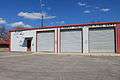
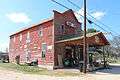
Photo gallery


Climate
The climate in this area is characterized by hot, humid summers and generally mild to cool winters. According to the Köppen Climate Classification system, Blanket has a humid subtropical climate, abbreviated "Cfa" on climate maps.[7]
References
- 1 2 "American FactFinder". United States Census Bureau. Archived from the original on 2013-09-11. Retrieved 2008-01-31.
- ↑ "US Board on Geographic Names". United States Geological Survey. 2007-10-25. Retrieved 2008-01-31.
- 1 2 "Geographic Identifiers: 2010 Demographic Profile Data (G001): Blanket town, Texas". U.S. Census Bureau, American Factfinder. Retrieved April 22, 2014.
- ↑ "US Gazetteer files: 2010, 2000, and 1990". United States Census Bureau. 2011-02-12. Retrieved 2011-04-23.
- ↑ "Annual Estimates of the Resident Population for Incorporated Places: April 1, 2010 to July 1, 2015". Retrieved July 2, 2016.
- ↑ "Census of Population and Housing". Census.gov. Archived from the original on May 11, 2015. Retrieved June 4, 2015.
- ↑ Climate Summary for Blanket, Texas
Municipalities and communities of Brown County, Texas, United States | ||
|---|---|---|
| Cities | 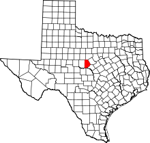 | |
| Town | ||
| CDPs | ||
| Other unincorporated communities | ||