Bokchito, Oklahoma
| Bokchito, Oklahoma | |
|---|---|
| Town | |
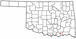 Location of Bockchito, Oklahoma | |
| Coordinates: 34°1′6″N 96°8′30″W / 34.01833°N 96.14167°WCoordinates: 34°1′6″N 96°8′30″W / 34.01833°N 96.14167°W | |
| Country | United States |
| State | Oklahoma |
| County | Bryan |
| Area | |
| • Total | 0.4 sq mi (1.0 km2) |
| • Land | 0.4 sq mi (1.0 km2) |
| • Water | 0.0 sq mi (0.0 km2) |
| Elevation | 640 ft (195 m) |
| Population (2010) | |
| • Total | 632 |
| • Density | 1,417.9/sq mi (632/km2) |
| Time zone | Central (CST) (UTC-6) |
| • Summer (DST) | CDT (UTC-5) |
| ZIP code | 74726 |
| Area code(s) | 580 |
| FIPS code | 40-07350[1] |
| GNIS feature ID | 1090368[2] |
Bokchito is a town in Bryan County, Oklahoma, United States. The population was 632 at the 2010 census, an increase of 12.1 percent from 564 at the 2000 census.[3] In the Choctaw language, "bok" means river or creek, and "chito" means big or large, literally translating into "big creek".[4]
History
The area around the present town of Bokchito was occupied by Choctaw Nation members following their removal from their homelands in the Southeastern U. S. Armstrong Academy was founded in 1844, about 2 miles (3.2 km) north of the area. A town formed by 1900 and moved to Bokchito's present location when the St. Louis and San Francisco Railway (Frisco) laid tracks through the area in 1903. Bokchito incorporated as a town within the Choctaw Nation on April 27, 1901. In 1901, the population was estimated at 200.[4]
Geography
Bokchito is located at 34°1′6″N 96°8′30″W / 34.01833°N 96.14167°W (34.018357, -96.141633).[5] It is 13 miles (21 km) east of Durant and 37 miles (60 km) west of Hugo.[4]
According to the United States Census Bureau, the town has a total area of 0.4 square miles (1.0 km2), all of it land.
Demographics
| Historical population | |||
|---|---|---|---|
| Census | Pop. | %± | |
| 1910 | 535 | — | |
| 1920 | 627 | 17.2% | |
| 1930 | 466 | −25.7% | |
| 1940 | 581 | 24.7% | |
| 1950 | 643 | 10.7% | |
| 1960 | 620 | −3.6% | |
| 1970 | 607 | −2.1% | |
| 1980 | 628 | 3.5% | |
| 1990 | 576 | −8.3% | |
| 2000 | 564 | −2.1% | |
| 2010 | 632 | 12.1% | |
| Est. 2015 | 657 | [6] | 4.0% |
As of the census[1] of 2000, there were 564 people, 248 households, and 150 families residing in the town. The population density was 1,417.9 people per square mile (544.4/km²). There were 293 housing units at an average density of 736.6 per square mile (282.8/km²). The racial makeup of the town was 78.19% White, 13.65% Native American, 0.35% Asian, 0.35% from other races, and 7.45% from two or more races. Hispanic or Latino of any race were 1.77% of the population.
There were 248 households out of which 27.0% had children under the age of 18 living with them, 46.0% were married couples living together, 10.5% had a female householder with no husband present, and 39.5% were non-families. 36.3% of all households were made up of individuals and 19.8% had someone living alone who was 65 years of age or older. The average household size was 2.27 and the average family size was 2.97.
In the town the population was spread out with 23.4% under the age of 18, 10.5% from 18 to 24, 22.2% from 25 to 44, 25.7% from 45 to 64, and 18.3% who were 65 years of age or older. The median age was 39 years. For every 100 females there were 80.8 males. For every 100 females age 18 and over, there were 81.5 males.
The median income for a household in the town was $21,923, and the median income for a family was $26,528. Males had a median income of $24,911 versus $20,000 for females. The per capita income for the town was $12,579. About 20.8% of families and 24.6% of the population were below the poverty line, including 34.5% of those under age 18 and 22.6% of those age 65 or over.
Economy
The economy of the area around Bokchito is based on agriculture and the production of beef and dairy cattle. Important crops have included cotton, corn, peanuts, oats, hay, and cucumbers.[4]
Education
The towns of Bokchito and Blue, Oklahoma consolidated their separate school districts to form the Rock Creek District. The elementary school is located in Blue, and the high school is in Bokchito.[4]
References
- 1 2 "American FactFinder". United States Census Bureau. Archived from the original on 2013-09-11. Retrieved 2008-01-31.
- ↑ "US Board on Geographic Names". United States Geological Survey. 2007-10-25. Retrieved 2008-01-31.
- ↑ CensusViewer:Bokchito, Oklahoma Population
- 1 2 3 4 5 Milligan, Keith. "Bokchito," Encyclopedia of Oklahoma History and Culture, Oklahoma Historical Society, 2009. Accessed April 15, 2015.
- ↑ "US Gazetteer files: 2010, 2000, and 1990". United States Census Bureau. 2011-02-12. Retrieved 2011-04-23.
- ↑ "Annual Estimates of the Resident Population for Incorporated Places: April 1, 2010 to July 1, 2015". Retrieved July 2, 2016.
- ↑ "Census of Population and Housing". Census.gov. Archived from the original on May 11, 2015. Retrieved June 4, 2015.
External links
Municipalities and communities of Bryan County, Oklahoma, United States | ||
|---|---|---|
| City | 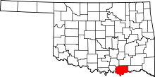 | |
| Towns | ||
| CDPs | ||
| Other unincorporated communities | ||
| Ghost towns | ||
| Achille | ||
|---|---|---|
| Bokchito | ||
| Caddo |
| |
| Colbert | ||
| Durant |
| |
| Kenefic | ||
| Nida | ||