Bormida, Liguria
| Bormida | |
|---|---|
| Comune | |
| Comune di Bormida | |
|
Church of Saint George | |
 Bormida Location of Bormida in Italy | |
| Coordinates: 44°17′N 8°14′E / 44.283°N 8.233°ECoordinates: 44°17′N 8°14′E / 44.283°N 8.233°E | |
| Country | Italy |
| Region | Liguria |
| Province / Metropolitan city | Savona (SV) |
| Frazioni | Chiesa, Fornelli, Piano Soprano, Piano Sottano, Resi, Costa, Pirotti, Navoni-Balteria, Romano |
| Government | |
| • Mayor |
Bruna Cambise In Falciani (elected June 13, 2004) |
| Area | |
| • Total | 22.43 km2 (8.66 sq mi) |
| Elevation | 485 m (1,591 ft) |
| Population (31 December 2006)[1] | |
| • Total | 453 |
| • Density | 20/km2 (52/sq mi) |
| Demonym(s) | Bormidesi |
| Time zone | CET (UTC+1) |
| • Summer (DST) | CEST (UTC+2) |
| Postal code | 17040 |
| Dialing code | 019 |
| Patron saint | Saint George |
| Saint day | 23 April |
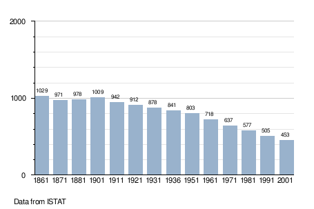
Bormida (Bormia in Ligurian), with a population of 453 spread over an area of 22.4 square kilometres (8.6 sq mi), is a rural commune of the Province of Savona in the Italian region Liguria. The commune is a member of the Comunità Montana Alta Val Bormida.
Location

Bormida is about 20 kilometres (12 mi) west of Savona (as the crow flies) in the upper Val Bormida between the mountain peaks of Settepani, elevation 1,386 metres (4,547 ft), and Ronco di Maglio, elevation 1,108 metres (3,635 ft). The Bormida di Pallare, a tributary of the Bormida di Spigno, flows through its territory.
Bormida borders the communes of Calice Ligure, Calizzano, Mallare, Osiglia, Pallare, and Rialto.
History
Bormida probably came into existence in the medieval period. However it does not appear in the documentary record until 1549 when Alfonso Del Carretto, lord of Finale Ligure, conceded certain privileges to the local population in a notarized deed.
In 1713, following a period of domination by the Spanish army, Bormida fell under the jurisdiction of the Republic of Genoa. Later in that century it acquired the status of a commune in its own right, rather than being a part of the commune of Osiglia, and was almost completely destroyed by the French army of Napoleon Bonaparte during his first Italian campaign.
From 1815 it followed the fortunes of the Kingdom of Sardinia, becoming part of the Kingdom of Italy in 1860.
Architecture
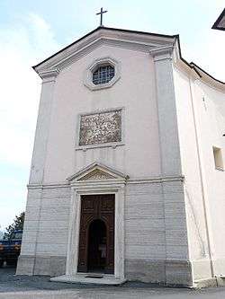
The parish church of San Giorgio, dating back to 1200, contains praiseworthy frescos and a wooden Madonna attributed to the sculptor Anton Maria Maragliano. The fifteenth-century campanile was remodelled in the Baroque style.
The palazzo “la Ferriera" (“the Iron-works”) is surrounded by a large and interesting park. Its name recalls the fact that iron working was the main economic activity of the area in centuries past.
Festivals
The feast of the Madonna del Carmine is celebrated on 16 July in the locality Piano Sottano, where a small church is dedicated to her.
Economy
The principle bases of the local economy are timber and agriculture. Cereals are grown, livestock is raised and cheese is produced.
Roads and railways
Bormida is situated on the Strada Provinciale 339 di Cengio which connects Cengio to Cortemilia. There is no direct link to any autostrada, but from the Autostrada A6 Verdemare, which links Turin to Savona, the Altare exit is the most convenient.
The nearest railway station is at Altare on the Turin–Savona line.
Demographic evolution
References
- As of 27 October 2007, most of this article was a translation from it:Bormida, its counterpart in the Italian Wikipedia which releases its content under the GFDL.
External links
- Comunità Montana Alta Val Bormida (Italian)