Bourtange
| Bourtange | |
|---|---|
| Village | |
|
Market square in the center of Fort Bourtange | |
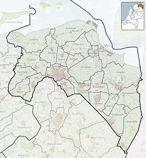 Bourtange Location in the province of Groningen | |
| Coordinates: 53°00′24″N 7°11′31″E / 53.0066°N 7.1920°ECoordinates: 53°00′24″N 7°11′31″E / 53.0066°N 7.1920°E | |
| Country | Netherlands |
| Province | Groningen |
| Municipality | Vlagtwedde |
| Area (2012)[1] | |
| • Total | 159 ha (393 acres) |
| • Land | 147 ha (363 acres) |
| • Water | 12 ha (30 acres) |
| Population (2012)[1] | |
| • Total | 430 |
| • Density | 270/km2 (700/sq mi) |
| Time zone | CET (UTC+1) |
| • Summer (DST) | CEST (UTC+2) |
| Postal code | 9545[2] |
| Area code | 0599[3] |
| ISO 3166 code | NL-GR |

Bourtange (Dutch pronunciation: [ˌbuːrˈtɑŋə]; Gronings: Boertang) is a village with a population of 430 in the municipality of Vlagtwedde in the Netherlands. It is situated in the region Westerwolde in the east of the province of Groningen near the German border. Fort Bourtange was built in 1593 during the Dutch Revolt and was used until 1851. The star fort was restored to its mid-18th-century state in 1960 and it is currently an open-air museum.
Etymology
The name Bourtange comes from the Dutch word tange (sand ridge), because the settlement is situated on a strategically important sand ridge in the marshes of the Bourtange Moor.[4]
History
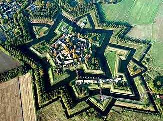
Fort Bourtange was initially built during the Eighty Years' War (circa 1568–1648) when William I of Orange wanted to control the only road between Germany and the city of Groningen which was controlled by the Spanish. This road followed a sandy ridge (tange) through the marshes (the Bourtange Swamp).
Later, around 1594, Bourtange became part of the fortifications on the border between the northern provinces (Groningen, Friesland, Drenthe) and Germany.
Bourtange was a separate municipality until 1822, when it was merged with Vlagtwedde.[5]
In 1851 the star fort was given up and Bourtange became a normal village.[6]
Around 1960 living conditions in the village deteriorated and it was decided that Bourtange would be rebuilt to its state of 1740-1750. Today it is an open-air museum.
Geography
Bourtange is located in the north of the municipality of Vlagtwedde and in the east of the province of Groningen near the German border. It is situated on a sand ridge in the Bourtange Moor, in the region of Westerwolde.
Demographics
In 2001, the town of Bourtange had 267 inhabitants. The built-up area of the town was 0.21 km², and contained 133 residences.[7] In 2005, the statistical area "Bourtange", which also can include the surrounding countryside, had a population of around 530.[8]
As of 2012, Bourtange has a population of 430 and a population density of 270/km2 (700/sq mi).[1]
References
- 1 2 3 (Dutch) Kerncijfers wijken en buurten, Statistics Netherlands, 2013. Retrieved on 19 January 2014.
- ↑ (Dutch) Resultaten voor "Bourtange,", Postcode.nl. Retrieved on 19 January 2014.
- ↑ (Dutch) Netnummer zoeken, Telefoonboek.nl. Retrieved on 19 January 2014.
- ↑ (Dutch) "Bourtange (gemeente Vlagtwedde)", Monumenten in Nederland. Groningen, 1998/2010. Retrieved on 19 January 2014.
- ↑ (Dutch) Ad van der Meer & Onno Boonstra, "Repertorium van Nederlandse gemeenten" Archived February 20, 2007, at the Wayback Machine., KNAW, 2006.
- ↑ "Vesting Bourtange". Retrieved 4 April 2013.
- ↑ (Dutch) Statistics Netherlands (CBS), Bevolkingskernen in Nederland 2001 Archived March 19, 2006, at the Wayback Machine.. (Statistics are for the continuous built-up area).
- ↑ (Dutch) Statistics Netherlands (CBS), Statline: Kerncijfers wijken en buurten 2003-2005 Archived 2006-07-24 at WebCite. As of 1 January 2005.
External links
| Wikivoyage has a travel guide for Bourtange. |
| Wikimedia Commons has media related to Bourtange. |
 |
Bellingwolde | Rhede | | |
| Vlagtwedde | |
Heede | ||
| ||||
| | ||||
| Sellingen | Dersum |