Bristol (CDP), Vermont
| Bristol (CDP), Vermont | |
|---|---|
| Census-designated place | |
 Bristol | |
| Coordinates: 44°8′0″N 73°4′44″W / 44.13333°N 73.07889°WCoordinates: 44°8′0″N 73°4′44″W / 44.13333°N 73.07889°W | |
| Country | United States |
| State | Vermont |
| County | Addison |
| Town | Bristol |
| Area | |
| • Total | 2.15 sq mi (5.58 km2) |
| • Land | 2.13 sq mi (5.51 km2) |
| • Water | 0.03 sq mi (0.07 km2) |
| Elevation | 571 ft (174 m) |
| Population (2010) | |
| • Total | 2,030 |
| • Density | 954/sq mi (368.3/km2) |
| Time zone | Eastern (EST) (UTC-5) |
| • Summer (DST) | EDT (UTC-4) |
| ZIP code | 05443 |
| Area code(s) | 802 |
| FIPS code | 50-08950[1] |
| GNIS feature ID | 1460661[2] |
Bristol is the main settlement in the town of Bristol in Addison County, Vermont, United States, and a census-designated place (CDP). The population was 2,030 at the 2010 census,[3] out of a total population of 3,894 in the town of Bristol.
Geography
The Bristol CDP is located in the northwest part of the town of Bristol, on the north side of the New Haven River as it exits the Green Mountains to the east. Vermont Route 17 passes through the community, leading west 5 miles (8 km) to U.S. Route 7 at New Haven Junction and east across the Green Mountains through Appalachian Gap 20 miles (32 km) to Waitsfield. Vermont Route 116 runs with VT 17 through Bristol but leads north 8 miles (13 km) to Starksboro and south 12 miles (19 km) to East Middlebury.
According to the United States Census Bureau, the Bristol CDP has a total area of 2.15 square miles (5.58 km2), of which 2.13 square miles (5.51 km2) is land and 0.03 square miles (0.07 km2), or 1.24%, is water.[3]
References
- ↑ "American FactFinder". United States Census Bureau. Archived from the original on 2013-09-11. Retrieved 2008-01-31.
- ↑ "US Board on Geographic Names". United States Geological Survey. 2007-10-25. Retrieved 2008-01-31.
- 1 2 "Geographic Identifiers: 2010 Demographic Profile Data (G001): Bristol CDP, Vermont". U.S. Census Bureau, American Factfinder. Retrieved August 19, 2015.
Municipalities and communities of Addison County, Vermont, United States | ||
|---|---|---|
| City | 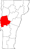 | |
| Towns | ||
| CDPs | ||
| Other communities | ||