Panton, Vermont
| Panton, Vermont | |
|---|---|
| Town | |
|
Logo of Panton | |
 Panton, Vermont | |
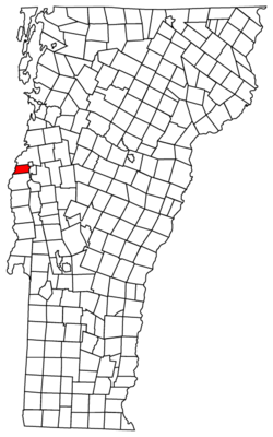
 Panton, Vermont Location in the United States | |
| Coordinates: 44°8′35″N 73°19′8″W / 44.14306°N 73.31889°WCoordinates: 44°8′35″N 73°19′8″W / 44.14306°N 73.31889°W | |
| Country | United States |
| State | Vermont |
| County | Addison |
| Area | |
| • Total | 22.0 sq mi (57.1 km2) |
| • Land | 15.5 sq mi (40.2 km2) |
| • Water | 6.6 sq mi (17.0 km2) |
| Elevation | 259 ft (79 m) |
| Population (2010) | |
| • Total | 677 |
| • Density | 44/sq mi (16.9/km2) |
| Time zone | Eastern (EST) (UTC-5) |
| • Summer (DST) | EDT (UTC-4) |
| ZIP code | 05491 |
| Area code | 802 |
| FIPS code | 50-53950[1] |
| GNIS feature ID | 1462169[2] |
| Website |
www |
Panton is a town in Addison County, Vermont, United States. The population was 677 at the 2010 census.[3]
Geography
Panton is located in northwestern Addison County, along the New York–Vermont border. The western side of the town extends into Lake Champlain, and Dead Creek is a broad water body that crosses the entire town south to north near the town center. Otter Creek forms much of the eastern border of the town. Neighboring towns and cities are Ferrisburgh to the north, Vergennes to the northeast, Waltham to the east, and Addison to the south. Bordering across Lake Champlain, which is approximately 2 miles (3 km) wide in this area, is the town of Westport, New York.
According to the United States Census Bureau, Panton has a total area of 22.0 square miles (57.1 km2), of which 15.5 square miles (40.2 km2) is land and 6.6 square miles (17.0 km2), or 29.70%, is water.[3] As is common in the Champlain Valley, much of the land in Panton is flat and suitable for agriculture. For centuries, locals have quarried and used a native stone, known as Panton Stone, for building foundations and walls.
Demographics
| Historical population | |||
|---|---|---|---|
| Census | Pop. | %± | |
| 1790 | 220 | — | |
| 1800 | 363 | 65.0% | |
| 1810 | 520 | 43.3% | |
| 1820 | 546 | 5.0% | |
| 1830 | 605 | 10.8% | |
| 1840 | 670 | 10.7% | |
| 1850 | 559 | −16.6% | |
| 1860 | 511 | −8.6% | |
| 1870 | 390 | −23.7% | |
| 1880 | 419 | 7.4% | |
| 1890 | 382 | −8.8% | |
| 1900 | 409 | 7.1% | |
| 1910 | 345 | −15.6% | |
| 1920 | 321 | −7.0% | |
| 1930 | 306 | −4.7% | |
| 1940 | 312 | 2.0% | |
| 1950 | 332 | 6.4% | |
| 1960 | 352 | 6.0% | |
| 1970 | 416 | 18.2% | |
| 1980 | 537 | 29.1% | |
| 1990 | 606 | 12.8% | |
| 2000 | 682 | 12.5% | |
| 2010 | 677 | −0.7% | |
| Est. 2014 | 675 | [4] | −0.3% |
| U.S. Decennial Census[5] | |||
As of the census[1] of 2000, there were 682 people, 248 households, and 192 families residing in the town. The population density was 44.1 people per square mile (17.0/km2). There were 276 housing units at an average density of 17.8 per square mile (6.9/km2). The racial makeup of the town was 96.92% White, 0.73% Native American, 0.15% Asian, and 2.20% from two or more races. Hispanic or Latino of any race were 0.15% of the population.
There were 248 households out of which 33.1% had children under the age of 18 living with them, 68.1% were married couples living together, 6.5% had a female householder with no husband present, and 22.2% were non-families. 16.1% of all households were made up of individuals and 8.5% had someone living alone who was 65 years of age or older. The average household size was 2.75 and the average family size was 3.06.
In the town the age distribution of the population shows 25.2% under the age of 18, 7.0% from 18 to 24, 27.0% from 25 to 44, 27.1% from 45 to 64, and 13.6% who were 65 years of age or older. The median age was 41 years. For every 100 females there were 98.8 males. For every 100 females age 18 and over, there were 98.4 males.
The median income for a household in the town was $46,184, and the median income for a family was $49,375. Males had a median income of $28,750 versus $24,375 for females. The per capita income for the town was $20,586. About 4.7% of families and 8.0% of the population were below the poverty line, including 10.0% of those under age 18 and 12.9% of those age 65 or over.
In popular culture
The station agent who advises the protagonist about visiting a secretive coastal town in H.P. Lovecraft's horror novella The Shadow Over Innsmouth says that he originally came from Panton.
References
- 1 2 "American FactFinder". United States Census Bureau. Retrieved 2008-01-31.
- ↑ "US Board on Geographic Names". United States Geological Survey. 2007-10-25. Retrieved 2008-01-31.
- 1 2 "Geographic Identifiers: 2010 Demographic Profile Data (G001): Panton town, Addison County, Vermont". U.S. Census Bureau, American Factfinder. Retrieved August 29, 2013.
- ↑ "Annual Estimates of the Resident Population for Incorporated Places: April 1, 2010 to July 1, 2014". Retrieved June 4, 2015.
- ↑ "U.S. Decennial Census". United States Census Bureau. Retrieved May 16, 2015.
External links
Municipalities and communities of Addison County, Vermont, United States | ||
|---|---|---|
| City | 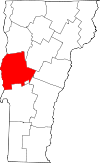 | |
| Towns | ||
| CDPs | ||
| Other communities | ||