Lincoln, Vermont
| Lincoln, Vermont | ||
|---|---|---|
| Town | ||
| ||
 Lincoln, Vermont | ||
 Lincoln, Vermont Location in the United States | ||
| Coordinates: 44°5′31″N 72°58′53″W / 44.09194°N 72.98139°WCoordinates: 44°5′31″N 72°58′53″W / 44.09194°N 72.98139°W | ||
| Country | United States | |
| State | Vermont | |
| County | Addison | |
| Chartered | 1780 | |
| Settled | 1790 | |
| Organized | 1798 | |
| Area | ||
| • Total | 44.6 sq mi (115.5 km2) | |
| • Land | 44.4 sq mi (115.0 km2) | |
| • Water | 0.2 sq mi (0.5 km2) | |
| Elevation | 1,263 ft (385 m) | |
| Population (2010) | ||
| • Total | 1,271 | |
| • Density | 29/sq mi (11.1/km2) | |
| Time zone | Eastern (EST) (UTC-5) | |
| • Summer (DST) | EDT (UTC-4) | |
| ZIP code | 05443 | |
| Area code | 802 | |
| FIPS code | 50-40075[1] | |
| GNIS feature ID | 1462135[2] | |
| Website |
www | |
Lincoln is a town in Addison County, Vermont, United States. The population was 1,271 at the 2010 census.[3]
Geography
Lincoln is located in northeastern Addison County in the Green Mountains. The Long Trail runs along the crest of the Green Mountains near the eastern border of the town, with elevations ranging from a low of 2,430 feet (740 m) at Lincoln Gap to a high of 4,006 feet (1,221 m) at the summit of Mount Abraham. The lowest elevation in the town is 840 feet (260 m) above sea level near West Lincoln, where the New Haven River exits the town.
The Lincoln Gap Road crosses the Green Mountains at Lincoln Gap, connecting the settled parts of Lincoln on the west with the town of Warren to the east. There are no numbered state highways in Lincoln.
According to the United States Census Bureau, the town has a total area of 44.6 square miles (115.5 km2), of which 44.4 square miles (115.0 km2) is land and 0.19 square miles (0.5 km2), or 0.43%, is water.[3]
Demographics
| Historical population | |||
|---|---|---|---|
| Census | Pop. | %± | |
| 1800 | 97 | — | |
| 1810 | 255 | 162.9% | |
| 1820 | 278 | 9.0% | |
| 1830 | 639 | 129.9% | |
| 1840 | 770 | 20.5% | |
| 1850 | 1,057 | 37.3% | |
| 1860 | 1,070 | 1.2% | |
| 1870 | 1,174 | 9.7% | |
| 1880 | 1,368 | 16.5% | |
| 1890 | 1,255 | −8.3% | |
| 1900 | 1,152 | −8.2% | |
| 1910 | 980 | −14.9% | |
| 1920 | 841 | −14.2% | |
| 1930 | 800 | −4.9% | |
| 1940 | 745 | −6.9% | |
| 1950 | 577 | −22.6% | |
| 1960 | 481 | −16.6% | |
| 1970 | 599 | 24.5% | |
| 1980 | 870 | 45.2% | |
| 1990 | 974 | 12.0% | |
| 2000 | 1,214 | 24.6% | |
| 2010 | 1,271 | 4.7% | |
| Est. 2014 | 1,272 | [4] | 0.1% |
| U.S. Decennial Census[5] | |||
As of the census[1] of 2000, there were 1,214 people, 462 households, and 339 families residing in the town. The population density was 27.6 people per square mile (10.7/km2). There were 566 housing units at an average density of 12.9 per square mile (5.0/km2). The racial makeup of the town was 97.53% White, 0.16% African American, 0.33% Native American, 0.66% Asian, 0.08% Pacific Islander, and 1.24% from two or more races. Hispanic or Latino of any race were 1.24% of the population.
There were 462 households out of which 37.2% had children under the age of 18 living with them, 61.3% were married couples living together, 8.9% had a female householder with no husband present, and 26.6% were non-families. 19.9% of all households were made up of individuals and 7.1% had someone living alone who was 65 years of age or older. The average household size was 2.63 and the average family size was 3.02.
In the town the age distribution of the population shows 27.1% under the age of 18, 5.9% from 18 to 24, 29.1% from 25 to 44, 27.1% from 45 to 64, and 10.8% who were 65 years of age or older. The median age was 39 years. For every 100 females there were 101.3 males. For every 100 females age 18 and over, there were 100.7 males.
The median income for a household in the town was $45,750, and the median income for a family was $51,369. Males had a median income of $30,455 versus $25,125 for females. The per capita income for the town was $21,092. About 4.3% of families and 5.9% of the population were below the poverty line, including 9.4% of those under age 18 and 1.5% of those age 65 or over.
History
Lincoln was chartered to Colonel Benjamin Simonds and 64 associates. The Colonel was well thought of in Vermont because of the assistance he and the Massachusetts militia had rendered at the Battle of Bennington three years earlier.
Colonel Simonds' new town was named in honor of his commanding officer, Major General Benjamin Lincoln (1733–1810), who had played a vital role in getting the militia to Vermont. General Lincoln is also credited with having prepared the way for the American victory at Saratoga by cutting Burgoyne's lines of communication with Canada.
Vermont seems to have made an especially nice gesture when it honored General Lincoln in the autumn of 1780. The tide of the Revolution had moved south; the General's troops had failed to retake Savannah, and they had lost Charleston in the spring of 1779. General Lincoln was captured and exchanged, and in 1780 he was serving under General Washington in the New York area.
Although relatively little known today, Lincoln was respected and liked by his contemporaries. Like George Washington, he was a farmer, and after the war he returned to farming at his home in Hingham, Massachusetts, though he was called into service several more times before his death. He was Secretary of War from 1781 to 1783; he led the Massachusetts militia in putting down Shays' Rebellion; he was asked to, and did, run in opposition to General Washington in the first Presidential election; he was lieutenant governor of Massachusetts in 1788, and was collector of the port of Boston from 1789 until just before he died at the age of 77.
Lincoln, like Ferrisburgh and several other Addison County towns, was settled by members of the Society of Friends, or Quakers. The first Quakers settled in an area known as Mud Flat about 1795. As time went by and other Quakers joined the original group, the area became known as Quaker Stand. The meeting house is gone and the Society has dispersed, but one part of Lincoln village is still called Quaker Street.[6]
On September 11, 2010, the first Tibetan Buddhist nunnery in North America was consecrated in Lincoln.[7]
Notable people
- Chris Bohjalian, author
- Ronald Rood, author and naturalist
- Randy Quaid, actor
References
- 1 2 "American FactFinder". United States Census Bureau. Retrieved 2008-01-31.
- ↑ "US Board on Geographic Names". United States Geological Survey. 2007-10-25. Retrieved 2008-01-31.
- 1 2 "Geographic Identifiers: 2010 Demographic Profile Data (G001): Lincoln town, Addison County, Vermont". U.S. Census Bureau, American Factfinder. Retrieved August 29, 2013.
- ↑ "Annual Estimates of the Resident Population for Incorporated Places: April 1, 2010 to July 1, 2014". Retrieved June 4, 2015.
- ↑ "U.S. Decennial Census". United States Census Bureau. Retrieved May 16, 2015.
- ↑ http://www.virtualvermont.com/index.php?loc=http://www.virtualvermont.com/towns/lincoln.html
- ↑ "Buddhist monastery for women opens in Bristol". The Eagle. September 18, 2010. Note: The title of the article says 'Bristol' but the nunnery is actually in Lincoln.
External links
Municipalities and communities of Addison County, Vermont, United States | ||
|---|---|---|
| City | 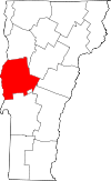 | |
| Towns | ||
| CDPs | ||
| Other communities | ||