Broadbeach Waters, Queensland
| Broadbeach Waters Gold Coast, Queensland | |||||||||||||
|---|---|---|---|---|---|---|---|---|---|---|---|---|---|
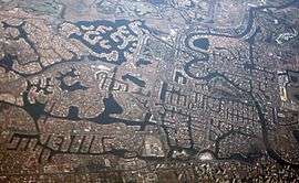 Residental canals on the Gold Coast, including Broadbeach Waters | |||||||||||||
 Broadbeach Waters | |||||||||||||
| Coordinates | 28°01′34″S 153°25′01″E / 28.026°S 153.417°ECoordinates: 28°01′34″S 153°25′01″E / 28.026°S 153.417°E | ||||||||||||
| Population | 7,514 (2011 census)[1] | ||||||||||||
| Postcode(s) | 4218 | ||||||||||||
| LGA(s) | Gold Coast City | ||||||||||||
| State electorate(s) | Mermaid Beach | ||||||||||||
| Federal Division(s) | Moncrieff | ||||||||||||
| |||||||||||||
Broadbeach Waters is a suburb on the Gold Coast in Queensland, Australia. Its local government area is the City of Gold Coast. At the 2011 Census, Broadbeach Waters had a population of 7,534.[1] The northern boundary of Broadbeach Waters follows the Nerang River. The suburb is almost completed residential with most properties adjacent to or very close to man-made canals. Pacific Fair Shopping Centre is located in the south east corner of the suburb.
Demographics
In the 2011 census, Broadbeach Waters recorded a population of 7,534 people, 50.6% female and 49.4% male.[1] The median age of the Broadbeach Waters population was 42 years, 5 years above the national median of 37. 64.4% of people living in Broadbeach Waters were born in Australia. The other top responses for country of birth were New Zealand 7.5%, England 5%, South Africa 1%, Germany 0.7%, United States of America 0.6%. 81.7% of people spoke only English at home; the next most common languages were 0.8% Mandarin, 0.7% Japanese, 0.7% Greek, 0.6% Italian, 0.5% Cantonese.[1]
See also
References
- 1 2 3 4 Australian Bureau of Statistics (31 October 2012). "Broadbeach Waters (State Suburb)". 2011 Census QuickStats. Retrieved 2009-05-10.