Buckland, Alaska
| Buckland Nunatchiaq | |
|---|---|
| City | |
|
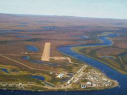
Aerial view of Buckland from the east | |
 Location in Northwest Arctic Borough and the state of Alaska. | |
| Coordinates: 65°59′5″N 161°7′47″W / 65.98472°N 161.12972°WCoordinates: 65°59′5″N 161°7′47″W / 65.98472°N 161.12972°W | |
| Country | United States |
| State | Alaska |
| Borough | Northwest Arctic |
| Incorporated | June 6, 1966[1] |
| Government | |
| • Mayor | Timothy Gavin, Jr. |
| • State senator | Donny Olson (D) |
| • State rep. | Benjamin Nageak (D) |
| Area | |
| • Total | 1.4 sq mi (3.7 km2) |
| • Land | 1.2 sq mi (3.2 km2) |
| • Water | 0.2 sq mi (0.5 km2) |
| Elevation | 13 ft (4 m) |
| Population (2010)[2] | |
| • Total | 416 |
| Time zone | Alaska (AKST) (UTC-9) |
| • Summer (DST) | AKDT (UTC-8) |
| ZIP code | 99727 |
| Area code | 907 |
| FIPS code | 02-09600 |
Buckland (Nunatchiaq in Iñupiaq) is a city in Northwest Arctic Borough, Alaska, United States. At the 2010 census the population was 416.
Geography
Buckland is located at 65°59′5″N 161°7′47″W / 65.98472°N 161.12972°W (65.984795, -161.129717).[3]
According to the United States Census Bureau, the city has a total area of 1.4 square miles (3.6 km2), of which, 1.2 square miles (3.1 km2) of it is land and 0.2 square miles (0.52 km2) of it (13.48%) is water.
Demographics
| Historical population | |||
|---|---|---|---|
| Census | Pop. | %± | |
| 1920 | 52 | — | |
| 1930 | 104 | 100.0% | |
| 1940 | 115 | 10.6% | |
| 1950 | 108 | −6.1% | |
| 1960 | 87 | −19.4% | |
| 1970 | 104 | 19.5% | |
| 1980 | 177 | 70.2% | |
| 1990 | 318 | 79.7% | |
| 2000 | 406 | 27.7% | |
| 2010 | 416 | 2.5% | |
| Est. 2015 | 431 | [4] | 3.6% |
As of the census[6] of 2000, there were 406 people, 84 households, and 75 families residing in the city. The population density was 332.3 people per square mile (128.5/km²). There were 89 housing units at an average density of 72.8 per square mile (28.2/km²). The racial makeup of the city was 3.20% White, 95.81% Native American, and 0.99% from two or more races. 1.23% of the population were Hispanic or Latino of any race.
There were 84 households out of which 66.7% had children under the age of 18 living with them, 65.5% were married couples living together, 20.2% had a female householder with no husband present, and 10.7% were non-families. 8.3% of all households were made up of individuals and 1.2% had someone living alone who was 65 years of age or older. The average household size was 4.83 and the average family size was 5.19.
In the city the age distribution of the population shows 51.2% under the age of 18, 10.8% from 18 to 24, 24.4% from 25 to 44, 10.1% from 45 to 64, and 3.4% who were 65 years of age or older. The median age was 18 years. For every 100 females there were . For every 100 females age 18 and over, there were 106.3 males.
The median income for a household in the city was $38,333, and the median income for a family was $40,000. Males had a median income of $31,563 versus $27,500 for females. The per capita income for the city was $9,624. About 7.9% of families and 11.9% of the population were below the poverty line, including 14.4% of those under age 18 and none of those age 65 or over.
References
- ↑ 1996 Alaska Municipal Officials Directory. Juneau: Alaska Municipal League/Alaska Department of Community and Regional Affairs. January 1996. p. 35.
- ↑ "2010 City Population and Housing Occupancy Status". U.S. Census Bureau. Archived from the original on July 21, 2011. Retrieved May 14, 2012.
- ↑ "US Gazetteer files: 2010, 2000, and 1990". United States Census Bureau. 2011-02-12. Retrieved 2011-04-23.
- ↑ "Annual Estimates of the Resident Population for Incorporated Places: April 1, 2010 to July 1, 2015". Retrieved July 2, 2016.
- ↑ "Census of Population and Housing". Census.gov. Archived from the original on May 11, 2015. Retrieved June 4, 2015.
- ↑ "American FactFinder". United States Census Bureau. Archived from the original on 2013-09-11. Retrieved 2008-01-31.
Municipalities and communities of Northwest Arctic Borough, Alaska, United States | ||
|---|---|---|
| Cities | 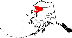 | |
| CDPs | ||
| Unincorporated communities | ||
| Ghost towns | ||