Bullfrog Valley, Arkansas
| Bullfrog Valley, Arkansas | |
|---|---|
| Unincorporated community | |
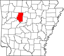
 Bullfrog Valley, Arkansas  Bullfrog Valley, Arkansas Bullfrog Valley's position in Arkansas. | |
| Coordinates: 35°31′08″N 93°12′46″W / 35.51889°N 93.21278°WCoordinates: 35°31′08″N 93°12′46″W / 35.51889°N 93.21278°W | |
| Country |
|
| State |
|
| County | Pope County, Arkansas |
| Elevation | 204 m (669 ft) |
| Time zone | Central (CST) (UTC-6) |
| • Summer (DST) | CDT (UTC-5) |
| GNIS feature ID | 59138 |
Bullfrog Valley, Arkansas is an unincorporated community in Illinois Township, Pope County, Arkansas, United States.[1] It is located on Arkansas Highway 164 near the Johnson County line. The community is also north of Silex.
References
This article is issued from Wikipedia - version of the 7/29/2016. The text is available under the Creative Commons Attribution/Share Alike but additional terms may apply for the media files.