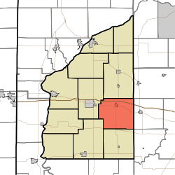
Cain Township, Fountain County, Indiana
| Cain Township | |
|---|---|
| Township | |
 | |
| Coordinates: 40°04′59″N 87°09′06″W / 40.08306°N 87.15167°WCoordinates: 40°04′59″N 87°09′06″W / 40.08306°N 87.15167°W | |
| Country | United States |
| State | Indiana |
| County | Fountain |
| Government | |
| • Type | Indiana township |
| Area | |
| • Total | 39.96 sq mi (103.5 km2) |
| • Land | 39.93 sq mi (103.4 km2) |
| • Water | 0.03 sq mi (0.08 km2) |
| Elevation[1] | 728 ft (222 m) |
| Population (2010) | |
| • Total | 1,142 |
| • Density | 28.6/sq mi (11.0/km2) |
| FIPS code | 18-09748 |
| GNIS feature ID | 453152 |
Cain Township is one of eleven townships in Fountain County, Indiana. As of the 2010 census, its population was 1,142 and it contained 488 housing units.[2]
History
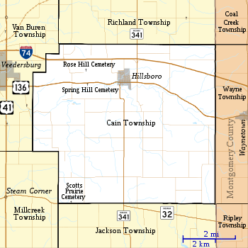
Cain Township was one of the first townships to be established in the county; it was established on July 24, 1826.[3] At that time, much of the land was forested, but 100 years later most of the land was used for agriculture. There were also several grain and lumber mills along Coal Creek, but these also were gone by the early 20th century. The town of Hillsboro was laid out in the 1830s and still exists; the town of Rynear was established in the far northwest corner of the township, but was gone by the early 1900s. The township's population was 1,763 in 1880, 1,537 in 1900, and 1,403 in 1910.[4]
Geography
According to the 2010 census, the township has a total area of 39.96 square miles (103.5 km2), of which 39.93 square miles (103.4 km2) (or 99.92%) is land and 0.03 square miles (0.078 km2) (or 0.08%) is water.[2] There is a single settlement in the township: the town of Hillsboro, which has a population of about 500 (about half the township's total population). This lies at the intersection of the east–west U.S. Route 136[5] and the north–south Indiana State Road 341,[6] in the northern part of the township. Interstate 74 passes from east to west less than 1 mile (1.6 km) north of Hillsboro.[7] Indiana State Road 32 runs along a portion of the southern border of the township.[8]
Cemeteries
The township contains three cemeteries. Rose Hill to the north and Spring Hill lie to the south of Hillsboro,[9][10] while Scotts Prairie is in the far southwest corner of the township.[11]
References
- ↑ "US Board on Geographic Names". United States Geological Survey. 2007-10-25. Retrieved 2008-01-31.
- 1 2 "Population, Housing Units, Area, and Density: 2010 - County -- County Subdivision and Place -- 2010 Census Summary File 1". United States Census. Retrieved 2013-05-10.
- ↑ Clifton 1913, p. 59.
- ↑ Clifton 1913, pp. 188–189.
- ↑ "U.S. Route 136". Highway Explorer. Retrieved 2010-09-21.
- ↑ "State Road 341". Highway Explorer. Retrieved 2010-09-21.
- ↑ "Interstate 74". Highway Explorer. Retrieved 2010-09-21.
- ↑ "State Road 32". Highway Explorer. Retrieved 2010-09-21.
- ↑ "Rose Hill Cemetery". Geographic Names Information System. United States Geological Survey. Retrieved 2011-09-05.
- ↑ "Spring Hill Cemetery". Geographic Names Information System. United States Geological Survey. Retrieved 2011-09-05.
- ↑ "Scotts Prairie Cemetery". Geographic Names Information System. United States Geological Survey. Retrieved 2011-09-05.
- "Cain Township, Fountain County, Indiana". Geographic Names Information System. United States Geological Survey. Retrieved 2009-09-24.
- United States Census Bureau 2010 TIGER/Line Shapefiles
- IndianaMap
Bibliography
- Beckwith, H. W. (1881). History of Fountain County, together with historic notes on the Wabash Valley. Chicago: H. H. Hill and N. Iddings, Publishers. pp. 472–492.
- Clifton, Thomas, ed. (1913). Past and Present of Fountain and Warren Counties Indiana. Indianapolis: B. F. Bowen and Company. pp. 25–200. Retrieved 2010-09-19.
External links
 |
Van Buren Township | Richland Township | Coal Creek Township, Montgomery County | |
| |
Wayne Township, Montgomery County | |||
| ||||
| | ||||
| Millcreek Township | Jackson Township |
Municipalities and communities of Fountain County, Indiana, United States | ||
|---|---|---|
| Cities | ||
| Towns | ||
| Townships | ||
| Unincorporated communities | ||